Search Results for "btc block reward💯earnmining.com": 217
Map shows the Distinction
In this portion of the 1886 Ohio Sanborn Map of downtown Cleveland, both the Cushing Block and the Cushing Building are…

Reward Poster, ca. 1910
The murder of William Lowe Rice, walking home one evening from the Euclid Club in 1910, was never solved, but his law…

The Two Campbell Block Buildings
Photos of the two Campbell Block buildings are hard to come by. In this 1916 photo, workers prepare a building on the…

The Hilliard Block
This 1851 illustration of the Hilliard Block appeared in the Cleveland Plain Dealer about one year after construction…

The Harding Block
In 1902, Cleveland Mayor Tom Johnson decided to build the new West Side Market on land situated near the northeast…

1930 Rouse Block Map
By 1930, The block-face holds the Ulmer Bldg (Mohawk Bldg.), the Marshall Building, and the "little building in the…

Looking North Along Public Square's Western Face
The City Hall is to the right of the Jail in the distance of this photograph showing both of Public Square's west block…

South View Along Cleveland's West Gate
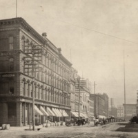
The Superior Street intersection separates the Rouse Block (foreground) from Public Square's southwest quadrant. Note…

Rouse Block Mapped in 1898
As its first one hundred years drew to a close, the Public Square block-face shows the American Trust Bldg. and the Dime…

Block Clubs
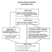
Moreland Community Association depended on the input and community activism of neighborhood block and street clubs.…

Stereograph of the Rouse Block
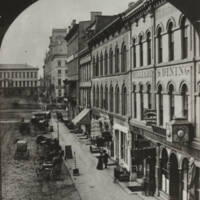
A view of Public Square, pond in the foreground with Superior Street (the Rouse Block) in the background. The signage…

Not Historic According to Condon
In this September 19, 1975 Plain Dealer article written just months before the last of the two Campbell Block buildings…

The American Trust Building
At the turn of the century the American Trust Building anchored the north coner of the Rouse Block. Cleveland's old…

The End of the Campbell Block
At one time, the two Campbell Block buildings almost entirely occupied the triangular piece of land east of West 25th…

The Cover Up
In the 1940s, several years after the 1939 death of Dr. Harvey Cushing, the Cushing Building was purchased by the parent…

The Second Building
This section of the 1896 Sanborn Map shows both the first and second buildings of the Campbell Block (circled in red). …

The Franklin Buildings
This advertisement from the Plain Dealer shows that George A. Davis's men's furnishings store occupied the Franklin…

The Plain Dealer Buildings
Just east of the Central Buildings stood another commercial block composed of a number of individual buildings. Also…

Getting to Know the Commercial Neighborhood
This section of the 1886-1887 Ohio Sanborn Map lists the names of many of the commercial buildings that once surrounded…

Erie-Huron-Prospect, Looking West
This photo, taken one year before the Rose Building construction got underway in the block on the far right, shows how…

The Shipbuilder's House
The house at 1794 W. 50th Street was built by William J. Miller in 1890, two years after the Isaac Kidd family moved…

Temple Court
Fenway Hall helped stimulate redevelopment in the Euclid-East 105th area in the mid-1920s, when much of the block was…

A Nineteenth Century View from St. Clair Avenue
This photograph was taken from St. Clair Avenue looking south. on Water (W. 9th) Street. The buildings shown on the…

The Campbell Block
A view of the Campbell Block from West 25th Street in circa 1964, about a decade before it was torn down. The…
