<?xml version="1.0" encoding="UTF-8"?>
<feed xmlns="http://www.w3.org/2005/Atom">
  <title type="text">Cleveland Historical</title>
  <updated>2026-05-02T04:00:30+00:00</updated>
  <generator uri="http://framework.zend.com" version="1.12.20">Zend_Feed_Writer</generator>
  <link rel="alternate" type="text/html" href="https://clevelandhistorical.org/"/>
  <link rel="self" type="application/atom+xml" href="https://clevelandhistorical.org/items/browse?output=rss2"/>
  <id>https://clevelandhistorical.org/</id>
  <author>
    <name>Cleveland Historical</name>
    <uri>https://clevelandhistorical.org</uri>
  </author>
  <link rel="hub" href="http://pubsubhubbub.appspot.com/"/>
  <entry>
    <title type="html"><![CDATA[Anthony J. Celebrezze Federal Building: Federal Modernism Comes to Cleveland]]></title>
    <summary type="html"><![CDATA[<p><strong><em>When the federal government began planning its new building as part of the Erieview Plan, it departed from I. M. Pei’s original vision and chose a stunning new design that drew from the latest in Modernist thought. Forty years later, that building was showing its age and required a dramatic intervention. The solution was an innovative facade overclad system that changed the building’s appearance but maintained its original purpose and function.</em></strong></p><img src="https://clevelandhistorical.org/files/fullsize/08179223f0e96be7ec08765e524e5ec3.jpg" alt="The Anthony J. Celebrezze Federal Building" /><br/><p>The 1960s were a very active period for the construction of federal buildings in cities across the country, and Cleveland was no exception. As early as 1957, area members of Congress began pushing for the construction of a centrally located downtown federal office building that would consolidate federal services in the city. The site of the building was determined in 1960 as an integral part of the Erieview Urban Renewal Project in downtown Cleveland. This large scale, multi-phased urban planning project was led by renowned architecture firm I. M. Pei and Associates.</p><p>Pei’s 1960 master plan for the Erieview development included a mix of high- and low-rise commercial and residential buildings with more than fifty percent of the land left open for parks and malls. The plan was designed to be completed in two phases; a western area of 96 acres to be designated for primarily commercial use and an eastern area of 67 acres to be designated for residential buildings. The focal point, at the center of the development, was a forty-story office tower. Completed in 1964 and dubbed the Erieview Tower, this was the first part of the Erieview plan to be built. A new six-story federal building that was to occupy an entire city block was also a key part of Pei’s plan. In preparation for the Erieview redevelopment, more than 200 buildings were demolished, including the old Armory that was located on the site of the current Federal Building.</p><p>While I. M. Pei developed the master plan for the Erieview development, other architects were brought in to design the individual buildings, including the new federal building. The General Services Administration (GSA), established in 1949 to meet the needs of the growing federal government, selected three local architecture firms to work together on the design of the federal building: Outcalt, Guenther, Rode, Toguchi & Bonebrake; Schafer, Flynn & Associates; and Dalton & Dalton Associates. However, the GSA did not choose a lead designer for the project and left the three firms to resolve the issue. All three firms wanted to lead the project, so a compromise was reached that they would bring in an outside architect to be the lead designer. The firm principals originally thought about bringing in a famous architect to lead the project, but eventually decided to find an architect that worked for one of these significant architects. Peter van Dijk was working for Eero Saarinen and Associates in Bloomfield Hills, Michigan, at the time and was selected based on a suggestion by one of Calvin Dalton’s employees. Upon speaking with van Dijk, the principals at the three firms quickly decided he was the right person to lead the design of the Federal Building project.</p><p>The design process began in 1961 and continued through 1962. The architectural team was charged with designing a one million square foot federal office building with an “open, flexible, well-planned loft space for offices.” GSA also requested that a two-level parking garage, large cafeteria, and loading dock be included. According to van Dijk, the goal was “to produce a most elegant steel cage. A façade executed with strength and precision. A stressed skin smoothness with machine-like clarity. Good proportion, scale, detail and choice of appropriate materials and colors.”</p><p>After careful consideration and study of the site and GSA programmatic requirements, it was decided that the team would design a tall building, which was in direct contradiction to the concept design in Pei’s Erieview Master Plan. The designers’ decision to abandon the Pei design was based on their belief that a tall structure would relate to the existing Terminal Tower and the other buildings being designed in proximity at the time. In their opinion, the large donut-shaped plan did not conform with the “plans for open space and plazas.” They believed a tall building would provide for more space for outdoor plazas, as well as views of the downtown and lake from the upper floor offices. Following their conclusion, the team convinced Pei and GSA that “a tall, slim structure would be more in keeping” with the other high structures planned in the renewal area. </p><p>
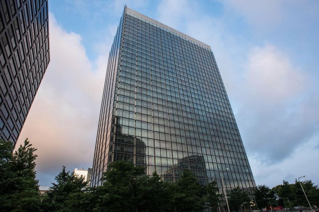
The building was designed as a simple rectangular shape and had the proportions of a golden rectangle. The design also contained a definite base, middle, and top and was intended to utilize simple materials (glass and stainless steel). Furthermore, according to van Dijk, the steel frame of the building became “the basis of the architectural expression of the façade.” The siting was also important to the designers. The building was purposely set back from East Ninth Street to provide room for a plaza at the main entrance and set back even farther on East Sixth Street to create a “garden plaza.”</p><p>The design was substantially completed by June 1962 when GSA issued an official press release regarding the new federal building in Cleveland. In the press release, GSA described the thirty-two story building as “an important element in the city’s Erieview Redevelopment Plan” that would “provide the lake-shore metropolis with an imposing landmark.” They also estimated that the building would cost $41.2 million to complete. </p><p>The Celebrezze Building was designed during a period of growing public acceptance of Modernist design. The Modernist movement in architecture, which had roots in Europe, began to flourish in the United States following World War II as architects like Walter Gropius and Mies van der Rohe expanded their influence. As the movement continued to thrive throughout the 1950s and into the 1960s, Modernism became the preferred style of architecture for office buildings across the country. Buildings such as the Seagram Building (1958) in New York City by Mies van der Rohe and Philip Johnson, as well as the Inland Steel Building (1957) in Chicago, Illinois by Bruce Graham and Walter Netsch of SOM, continued to push the envelope in Modernist design. Significant Modernist skyscrapers in Cleveland include the McDonald Investment Center (1968) by Charles Luckman; the Cleveland Trust Tower/Ameritrust Tower (1971) by Marcel Breuer; Earnest J. Bohn Housing Tower (1972) by William Dorsky Associates; the Diamond Building (1972) by SOM; the Holiday Inn Lakeside (1974) by William Bond; and the Sheraton City Centre Hotel (1975) – now the Crowne Plaza Hotel – by Bialosky and Manders.</p><p>The policies of the federal government also reflected the shift toward Modernist design. When John F. Kennedy assumed the presidency in 1961, he found many federal buildings to be lacking in efficient office space and inadequate for modern use. As a result, he requested that an Ad Hoc Committee on Federal Office Space be formed to develop solutions for short- and long-term space needs in federal buildings. In 1962 the committee issued its report, which included the “Guiding Principles for Federal Architecture.” In the “Guiding Principles” the committee recommended new mandates for “high quality architectural designs” for all new federal buildings across the country and developed a three-point system for federal architecture standards. They also encouraged modern principles of architecture through choice words within the standards, such as “contemporary,” “functional,” and “economical.” With the adoption of the new principles, the monotonous architecture of the previous decade gave way to new, innovative, quality design. Although the design of the Celebrezze Building was initiated before the Principles were published, it clearly exemplifies the Principles’ embrace of high-quality modern design.</p><p>The building’s expression of structure on the exterior façade follows the design principles of Mies van der Rohe, which can be seen in many of his works, including the Dirksen Federal Courthouse in Chicago completed in 1965. However, unlike Mies who used protruding mullions on his buildings, Peter van Dijk used only contrasting materials – stainless steel and glass – to emphasize the grid of columns and floor plates. According to van Dijk, the solid of the stainless steel and the void of the glass created a solid and void effect that clearly emphasized the building’s skeletal structure. The idea of an exterior skin with no protruding mullions was a concept van Dijk learned in the office of Eero Saarinen from projects such as the General Motors Technical Center in Warren, MI, and Bell Labs in Holmdel, NJ. It continued to be the subject of experimentation with other Saarinen followers, most notably Anthony Lumsden and Cesar Pelli. </p><p>In 1965, in the midst of the Civil Rights era, the construction of the new federal building in Cleveland became the subject of protests that received nationwide attention. Led by the National Association for the Advancement of Colored People (NAACP), picketers protested discriminatory hiring practices among the predominantly white trades unions involved in the construction of the building. The protest’s leadership also targeted the federal government “for its failure to enforce civil rights laws.” The Erieview plan, of which the federal building was a part, also appears to have strained community relations. Across the country at this time, many cities had undertaken similar projects that resulted in the displacement of their most vulnerable residents and the destruction of their homes, with disproportionate effects being felt by the African American population. In Cleveland, many poor Black residents perceived that the Erieview project, which was located in the heart of the downtown area and treated as a showpiece by politicians and government officials, was diverting badly needed resources from projects in critically underserved east side neighborhoods. This resentment, combined with myriad other factors, burst out into the open the following summer in the Hough Uprisings, an episode of violent unrest comparable to the riots that occurred in Harlem, Watts, and other urban areas during the 1960s. </p><p>The Cleveland Federal Building was substantially completed in the fall of 1966 at a cost of $31,968,000 (substantially less than the budgeted $41.2 million) and officially opened in early 1967. The new building housed more than fifty government agencies that had previously been spread out in buildings throughout the city. In 1973, the building was renamed in dedication of Anthony J. Celebrezze, former Mayor of Cleveland, Ohio Congressman, Secretary of Health, Education and Welfare in the Kennedy Administration, and U.S. Appeals Court Judge. As mayor, Celebrezze was an early proponent of the Erieview Urban Redevelopment Project and helped in the process of bringing the Federal Building project to realization. </p><p>Following its completion, the building underwent relatively few significant alterations until 2009, when GSA utilized funds available through the American Recovery and Reinvestment Act (ARRA) to begin a massive intervention addressing the condition of the curtain wall. Flaws in the original detailing and installation, water infiltration, the action of wind forces, and the harsh Cleveland winters had resulted in advanced deterioration on the façade’s various components. Additional assessments found the curtain wall to be strikingly deficient in terms of modern energy efficiency and security standards. Ultimately GSA decided to install a second skin on top of the existing façade, effectively overcladding the original building with an entirely new window wall system. </p><p>Pursuing this innovative approach allowed GSA to retain the existing building, thereby avoiding the expense and inefficiency of constructing an entirely new building and relocating the current building’s occupants. Additionally, it allowed the agency to preserve a historic asset. In 2011, the Celebrezze Building was determined eligible for listing in the National Register of Historic Places for its exceptional local historic and architectural significance. This determination rests on the Celebrezze Building’s distinguished modernist design and its role in the history of the Erieview plan and the development of the modern Cleveland skyline. It also recognizes Peter van Dijk as a master architect. Comparatively unknown at the time that he designed the Celebrezze Building, van Dijk went on to become one of the Cleveland area’s most celebrated designers. Following the Celebrezze Building, he designed the Blossom Music Center (1968) in Cuyahoga Falls. Subsequently, his firm developed a global reputation for expertise in the design of performance venues. A committed preservationist, van Dijk was also a driving force behind the plan to save Cleveland’s Playhouse Square theaters. Recognizing the need to address issues with the original design and construction of the Celebrezze Building, van Dijk supported and participated in the façade renewal project. Peter van Dijk passed away in 2019 at age 90.</p><p>Following the completion of the facade overcladding, the Celebrezze Building was identified as a contributor to the Erieview Historic District, which was listed in the National Register of Historic Places in 2021.</p><p><em><strong><a href="https://clevelandhistorical.org/items/show/1004">For more (including 13 images) view the original article</a></strong></em></p>]]></summary>
    <published>2023-06-10T14:32:46+00:00</published>
    <updated>2026-04-17T19:17:43+00:00</updated>
    <link rel="alternate" type="text/html" href="https://clevelandhistorical.org/items/show/1004"/>
    <id>https://clevelandhistorical.org/items/show/1004</id>
    <author>
      <name>Jorgen Cleemann</name>
    </author>
  </entry>
  <entry>
    <title type="html"><![CDATA[Erieview: Cleveland&#039;s &quot;Surrogate Downtown&quot;]]></title>
    <summary type="html"><![CDATA[<p><strong><em>It was not the first time Cleveland saw a grand scheme to reorient its downtown toward the lakefront. I. M. Pei’s conception reprised, updated, and extended eastward the early 20th-century Group Plan designed by the “City Beautiful” architect Daniel Burnham of Chicago.</em></strong></p><img src="https://clevelandhistorical.org/files/fullsize/e70db4101b8c2844f1cba6f7aea5a203.jpg" alt="Erieview Plan Bird&#039;s-eye View" /><br/><p>In 1973, architectural critic Ada Louise Huxtable described "a huge, bleak, near empty plaza with a complete set of non-working fountains and drained pools, focusing on a routine glass tower by New York architects Harrison and Abramovitz, known to Clevelanders as the 'jolly green giant.'" She lamented that the plaza was flanked by "vast, open parking lots." Huxtable was referring to Erieview Plaza and Erieview Tower, together the focus of the Erieview urban renewal project, which she derided as a "monument to everything that was wrong with urban renewal thinking in America in the 1960s." Erieview attracted more than architectural criticism. Some Clevelanders also argued that the project set back the downtown district it was intended to revitalize. <em>Plain Dealer</em> columnist Philip W. Porter called Erieview "the mistake that ruined downtown." Porter wasn't alone. Even in the 1960s, some downtown interests worried that Erieview, which some considered a "surrogate downtown," might siphon energy away from the downtown shopping district. Would Erieview workers continue to walk several blocks to Euclid Avenue to shop on their lunch break, or would they demand amenities in a new, self-contained city-within-a-city?</p><p>Erieview was born of the same concerns about downtown stagnation that gripped many U.S. cities by the 1950s. Pittsburgh’s Gateway Center became a national model for downtown renewal, and Cleveland leaders formed the Cleveland Development Foundation (CDF) in 1954 to emulate Pittsburgh’s Allegheny Conference on Community Development. CDF weighed whether to launch its urban renewal effort (with federal dollars matching municipal expenditures in a 2:1 ratio) in downtown in a subsidized version of Pittsburgh's privately financed downtown renewal or start in east-side neighborhoods. Local architect Richard Hawley Cutting even drew a plan, pro bono, that he pitched to CDF. Called Erie View, it featured a geometric assemblage of modernist towers and plazas along the lakefront to the east of East 9th Street. CDF, whose chairman was Republic Steel president Tom Patton, rejected that urban renewal and, in 1956, proceeded instead with another, dumping Republic Steel slag in Kingsbury Run and building the euphemistically named Garden Valley, which offered substandard housing and exacerbated residential segregation. </p><p>A succession of failed downtown projects (among them the collapse of a plan for underground parking beneath <a href="https://clevelandhistorical.org/items/show/312">the Mall</a>, voters' rejections of a convention center expansion, and county commissioners' denial of a downtown subway) led to a series of secret meetings in the spring of 1959. Weary of the slow pace of neighborhoods-first renewal and impatient with the CDF-commissioned $100,000 downtown plan due out later that year, CDF president Upshur Evans, Cleveland Chamber of Commerce president Curtis Lee Smith, and Cleveland Urban Renewal and Housing Director James M. Lister convened to strategize how to catalyze downtown revitalization. They consulted with Chase Manhattan Bank's David Rockefeller in the hope he might invest in Cleveland. He refused but reinforced their belief that only a large, coordinated plan was worthwhile. They turned to Newark-based Prudential Insurance to try to interest the company in a regional headquarters along Lake Erie. They too demurred.  </p><p>Undeterred, the trio bypassed the Cleveland Planning Commission and went straight to Mayor Anthony Celebrezze, who saw in their idea a project he could sell. Unveiled in January 1960, the plan, christened Erieview, promised the nation's largest downtown urban renewal project, a reflection of city leaders' desire to make up for lost time. They pronounced the 125-acre renewal area (roughly bounded by the Memorial Shoreway, East 9th Street, Chester Avenue, and East 17th Street) “blighted,” sealing the fate of many small businesses and manufacturers and some single-room-occupancy hotels. The city commissioned prominent modernist architect I. M. Pei to design the Erieview plan, which looked like many other plans of its era – a Tetris board of low-slung, interlocking buildings wrapping around open plazas punctuated by taller towers. The tallest of them was plotted between East 9th and 12th Streets with an open plaza and reflecting pool. It was not the first time Cleveland saw a grand scheme to reorient its downtown toward the lakefront. Pei’s conception reprised, updated, and extended eastward the early 20th-century Group Plan designed by the “City Beautiful” architect Daniel Burnham of Chicago.</p><p>Developers John Galbreath and Peter Ruffin planned to build one or more office towers in Erieview, including the focal building at its heart. The 529-foot-tall, 40-story Erieview Tower was designed by the New York firm of Harrison and Abramovitz. Firm partner Wallace Harrison was best known for his work on Rockefeller Center and the United Nations, but the Erieview design more closely resembled the firm's 45-story Socony-Mobil Building (1956) in New York, also developed by Galbreath and Ruffin. Erieview Tower was a simplified version of its predecessor, substituting black and green glass curtain walls for black windows and silver patterned aluminum walls. Yet both buildings were later panned by some as "ugly" designs. True to its nickname, the greenish tower did loom, giant-like, over the wide-open expanse of Erieview Plaza whose fountains and reflecting pool doubled as an ice rink in winter. Widespread clearance left mostly parking lots surrounding Erieview Plaza for years.</p><p>Erieview was billed as an antidote for an ailing downtown, on one hand, and as an outlet for downtown's expected office boom, on the other. While these aims may appear contradictory – one intended to reverse decline and another to accommodate anticipated growth – they actually reflected the complex situation facing downtowns in the 1960s. Suburban retail competition was causing downtown shopping to wither, but at the same time many firms were eager for more spacious, modern office space. Erieview initially spurred overdue renovations by several leading downtown department stores. That their efforts ultimately failed to save them owed less to Erieview than to the effects of population decline, suburban retail growth, and the city's failure to cultivate a strong convention trade. Office expansion promised a counterpoint to retail slippage. After Erieview Tower, the 32-story Federal Building (1967), two major hotels (today’s Westin and Doubletree) and a half-dozen major office towers, including headquarters for Diamond Shamrock (1972) and Eaton (1983), opened incrementally over the next two decades.  </p><p>No sooner had Erieview been fleshed out than it started to clear out. Downtown employment dropped by one-third in the forty years after 1970, and by the 21st century the main demand was for more living space. Boosters had long predicted a return to the central city. Erieview added three apartment towers (including Reserve Square) between 1967 and 1973, but it would take another four decades before downtown became a true residential magnet, aided by conversions of old office buildings using historic preservation tax credits. In 2010, the Downtown Cleveland Alliance rebranded the Erieview area, nearly one-third vacant, as a "live–work–play" concept dubbed the Nine-Twelve District. As renovators exhausted the supply of historic buildings, midcentury properties were just crossing the fifty-year threshold to qualify as "historic." In 2018, developer James Kassouf bought Erieview Tower, newly listed on the National Register, with plans to convert twelve vacant floors into apartments. Downtown's northeastern quadrant once had hundreds of units of low-rent housing, but these held no place in the vision of Cleveland’s boosters. They yielded to civic aspirations for a new downtown of gleaming office towers. Although Erieview, recast as Nine-Twelve, is reemerging as a neighborhood, its upmarket housing inventory ensures that it can’t rightly be said to have come full circle.</p><p><em><strong><a href="https://clevelandhistorical.org/items/show/909">For more (including 14 images&#32;&amp;&#32;3 audio files) view the original article</a></strong></em></p>]]></summary>
    <published>2020-05-10T21:26:19+00:00</published>
    <updated>2026-04-17T19:17:42+00:00</updated>
    <link rel="alternate" type="text/html" href="https://clevelandhistorical.org/items/show/909"/>
    <id>https://clevelandhistorical.org/items/show/909</id>
    <author>
      <name>J. Mark Souther</name>
    </author>
  </entry>
  <entry>
    <title type="html"><![CDATA[Gladstone (Area O): Urban Renewal and &quot;The Worst Slum in Cleveland&quot;]]></title>
    <summary type="html"><![CDATA[<img src="https://clevelandhistorical.org/files/fullsize/100920d23fdacc454751a8aeae879c6c.jpg" alt="Map of Area O, 1956" /><br/><p>Urban renewal in Cleveland functioned as a tool to improve neighborhoods, thus invigorating the city. In tandem with the goal of strengthening neighborhoods, industrial renewal projects were also a focus for Cleveland officials. Among the most prominent urban renewal projects in Cleveland that focused on revitalizing a space for industrial growth was Gladstone (Area O), which was often called "the worst slum" in Cleveland. </p><p>Influenced by early projects in Pittsburgh that were funded through local public-private cooperation, Gladstone was originally intended to be done entirely through private investment with participation with local business and industry. In accordance with the General Plan for Cleveland of 1949, the area was to be redeveloped for full industrial use, particularly for food distribution. Among the biggest food distributors in Gladstone was the Northern Ohio Food Terminal, which accounted for nearly $200 million annually in the late 1950s and early 1960s. The project was intended to provide space for industrial relocation to keep industries from moving outside of Cleveland by making land available and cheap in the central core of the city. </p><p>Gladstone covered about 97.4 acres and had an irregular border that was situated between Woodland Avenue to the north and the Nickel Plate and New York Central railroad tracks to the south. Its borders on the west and east extended from East 37th Street to East 55th Street. The area was approved as an urban renewal project in April of 1957. At the onset of the project, around 20 percent of the land served residential uses, while the other 80 percent was occupied for industrial purposes. The two largest industries in the area were food packing and distribution, and scrap metal businesses were scattered along the edges of the project. </p><p>The City Planning Commission found that about 79 percent of residential and about 26 percent of industrial structures were dilapidated and unfit for use. They also found that virtually no public recreation space existed in the project area.</p><p>Gladstone, however, quickly encountered problems as the project developed. Among the biggest problems was the cost. Gladstone was more expensive than originally anticipated, which made it difficult to find businesses that were willing to pay the extra cost for land. The city of Cleveland was selling land in Gladstone at about $3.00 per square foot to cover the cost of obtaining and clearing the land. Industry at this time, the 1950s and 1960s, usually did not spend more than $1.75 per square foot of land. </p><p>There were also claims that the City Planning Commission intentionally condemned properties and labeled them as dilapidated and unsafe in order to drive down property values. This, in theory, would have allowed the city to buy the condemned land at a cheaper cost in which they could then sell back to industries interested in building or expanding in Gladstone. A more accurate survey by Housing Commissioner Robert Greenhalgh in 1960 found that only about 10 percent of the structures were in such a dilapidated condition that they had to be torn down. </p><p>The cost of land in Gladstone brought private investment to a standstill. Because industry was not willing to pay the prices the city needed in order to not lose money on the project, Urban Renewal Director James M. Lister and Mayor Celebrezze had to seek federal aid in 1963 to ensure the project would move forward. </p><p>Even with federal aid for urban renewal, the project took a long time to get underway. By 1966, the Plain Dealer noted that only about three acres of land were sold by the city. By 1968, ten parcels of land in the area still needed to be acquired by the city. The lack of industrial interest in Gladstone demonstrates that, even with federal price reductions through urban renewal aid money, land in the suburbs was cheaper. </p><p>The City of Cleveland was also required to help relocate families for the duration of the urban renewal project. The Plain Dealer also noted in 1966 that of the 700 families that were living in Gladstone at the beginning of the project, roughly 300 were still living in the area. To make matters worse, about 70 percent of the families that were relocated were either unaccounted for or moved to substandard housing somewhere else in the city. </p><p>As the project stagnated into the late 1960s, the area became little more than a dumping ground for other urban renewal projects in the city of Cleveland. The large trash heaps that accumulated in Gladstone were often burned, which in a few cases spread to nearby abandoned buildings. Some businesses in the area even noted that the trash fires caused their insurance rates to increase, which unfortunately only further deterred new investment in Gladstone. </p><p>Although the Northern Ohio Food Terminal did retain its facilities in Gladstone, other companies and industries were not attracted to the area with the fervor that was anticipated. Stouffer Foods Corp., a new postal service office, and a new terminal for the Railway Express Agency all chose to move or build outside of Gladstone for the same reasons; it was cheaper to buy land and build in the suburbs, and the city of Cleveland was taking too long to actually have land ready for sale. </p><p>Some businesses and industries did build in Gladstone, though too many years after the start of the project to justify all the problems it created. The federal government put a freeze on funding for Cleveland urban renewal projects because of concerns of mismanagement. It was not until Mayor Carl Stokes took office in 1967 that projects, including Gladstone, started showing improvement. Gladstone, however, never quite realized its full potential and became little more than an example of what could go wrong with urban renewal. </p><p>In 1990, a local non-profit called Maingate Business Development Corporation was created to work at reversing the negative impact the Gladstone project had on the area. Maingate actively works at regaining the confidence of corporations and businesses in the area and forty new companies have chosen to have a location in the Maingate area. Although the effects of Gladstone are being reversed by Maingate, work is still being done to fully realize the potential city officials believed the area had in the 1950s and 1960s. </p><p><em><strong><a href="https://clevelandhistorical.org/items/show/870">For more (including 6 images) view the original article</a></strong></em></p>]]></summary>
    <published>2019-06-14T02:26:10+00:00</published>
    <updated>2026-04-17T19:17:39+00:00</updated>
    <link rel="alternate" type="text/html" href="https://clevelandhistorical.org/items/show/870"/>
    <id>https://clevelandhistorical.org/items/show/870</id>
    <author>
      <name>Matt Saplak </name>
    </author>
  </entry>
  <entry>
    <title type="html"><![CDATA[Longwood (Area B) Urban Renewal Project: “Cleveland&#039;s Cabrini-Green”]]></title>
    <summary type="html"><![CDATA[<img src="https://clevelandhistorical.org/files/fullsize/6c150088116468d0ad1c72c3e83d8633.jpg" alt="Plan for Longwood Community Center and Pool, 1957" /><br/><p>Beginning in 1955, Longwood (Area B) was the first urban renewal project in accordance with the General Plan for Cleveland of 1949. The small, yet densely populated, neighborhood of about 56 acres was bordered by Scovill and Woodland Avenues to the north and south; and by East 33rd and East 40th Streets to the west and east. The project served as a model for subsequent urban renewal projects in Cleveland, though not always a positive one. Opposition and criticism to the project was visible since the beginning and would continue through the following years. Roadell Hickman stated in a <em>Plain Dealer</em> editorial in 1987, “Longwood became Cleveland’s Cabrini-Green, the notorious Chicago public-housing project. Both began with a vision to save a neighborhood but became a symbol of what was destroying it.” Longwood and Cabrini-Green did have some differences, however. The Cabrini-Green project in Chicago was intended to be public housing, whereas Longwood was not intended to be public housing, but rather low-cost housing. </p><p>The General Plan for Cleveland was formed as a flexible blueprint for city growth up until the 1980s. Longwood (Area B), among the other urban renewal projects in Cleveland, was a response to growing blight and decay in inner city neighborhoods. The city government of Cleveland was proactive about maintaining and developing its inner city since the beginning of the 20th century. A city planning commission was established in 1915, and in 1933 Cleveland established the Metropolitan Housing Authority. Local businesses and corporations also took action and formed the Cleveland Development Foundation in 1954 with a revolving fund of $2 million to invest in urban renewal. Businesses and corporations in Cleveland believed that by creating a better inner city in close proximity to jobs, they could attract middle class workers that relocated to the suburbs. </p><p>In 1955, the Longwood neighborhood had a total of 295 dilapidated buildings that housed around 1,500 families. The project called for the total clearance of the area, with the exception of a few churches and city buildings. The area consisted of five privately owned developers and called for the construction of 836 new dwellings throughout the neighborhood, as well as shopping centers and an improved street plan. Various city agencies touted the project as an almost immediate success story through multiple newspaper articles and city publications. The land was acquired, leveled, and rebuilt relatively quickly and new residents were moving in as early as 1958. Any small success of the project was covered in the local newspapers to paint a clear picture that Longwood was right on track to become the model that the city government hoped it would be. </p><p>Despite the proclaimed success of the project by city publications, problems and critics were prevalent and visible from the beginning. Critics claimed that the project was far too expensive and was taking too much time to fully complete with the quality that was initially envisioned. The project, as well as most urban renewal projects, also disproportionally affected African Americans, which caused many residents to speak out against it. According to <em>Renewing Inequality, </em>of the 1,100 people displaced by the project by 1961, 99% of them were people of color. Tenants also consistently made claims of mismanagement, pest problems, and poorly built structures. According to Residents also had to be relocated for the duration of the construction of the project and some found themselves in a worse situation than they were before having to move out of Longwood. Tenants also picketed and protested their grievances several times, with the first tenant strike occurring in 1958. Tenants in a small section of Longwood (Area B) called Longwood Village organized a strike with grievances that included high rents and rent increases, racial discrimination, rats, and property mismanagement. The primary cause for the strike, being rent prices, was never resolved on account of rents being set and controlled by the Federal Housing Administration. Everyone involved, however, did agree that the rents were too high to be considered low cost housing. The rent strikes reveal a major concern with urban renewal that civic and business leaders did not foresee. Longwood was still surrounded by other slums and dilapidated neighborhoods and the new housing was not affordable. Middle-class suburbanites did not want to move into the inner city and the inner-city community could not afford the new housing. Eugene Segal, a reporter for the <em>Plain Dealer</em>, stated, “If one group can’t afford the new housing and the other won’t have it, whom are we building for?” </p><p>The housing developments in Longwood (Area B) changed ownership multiple times over the decades following the project. Excessive vacancies in the housing developments caused the owners to default on their mortgage payments in 1963. To stop them from foreclosing, the Cleveland Development Foundation set up a subsidiary called the Longwood Housing Association to take advantage of a new Federal Housing Administration amendment and get a loan. The loan paid off banks and money lenders first, then a portion of it was used to pay developers to help recoup their losses, and what was left was paid to the city of Cleveland which was only about half of what the Cleveland Development Foundation initially paid in advance to the builders of the project. </p><p>The grand ambitions of the Longwood (Area B) project were unfortunately never realized. Financial, management, and vacancy problems continued to plague the neighborhood into the 1990s. A new type of subsidized housing was built in the early 2000s, which replaced Longwood Apartments. The new housing development was named Arbor Park Village and was intended to include educational classes, recreational activities, and resources to help people find better jobs. Though flaws persisted in Longwood (Area B) in the decades following the project, perhaps Arbor Park Village can fulfill some the original promises that were made.</p><p><em><strong><a href="https://clevelandhistorical.org/items/show/854">For more (including 14 images) view the original article</a></strong></em></p>]]></summary>
    <published>2018-11-21T19:48:39+00:00</published>
    <updated>2026-04-17T19:17:42+00:00</updated>
    <link rel="alternate" type="text/html" href="https://clevelandhistorical.org/items/show/854"/>
    <id>https://clevelandhistorical.org/items/show/854</id>
    <author>
      <name>Matt Saplak </name>
    </author>
  </entry>
  <entry>
    <title type="html"><![CDATA[Sutton Place: An Experiment with Suburban Renewal]]></title>
    <summary type="html"><![CDATA[<p><strong><em>Following five years of land acquisitions, demolition and construction, the Sutton Place townhouse development opened for sale to the public in May of 1971.  The experimental, aluminum-based housing project was designed to draw middle- and upper-class professionals into the Moreland neighborhood.  The new housing emerged from a controversial urban renewal project headed by the City of Shaker Heights during the late 1960s, and was greeted with picket signs by the Cleveland Association of Real Estate Brokers.  Learn why...   </em></strong></p><img src="https://clevelandhistorical.org/files/fullsize/d30be98a5b9ab816657464798ced5af6.jpg" alt="Architectural Sketch of Sutton Place Townhouses, 1970" /><br/><p>Standing before a crowd of 200 community members in the fall of 1968, City of Shaker Heights Mayor Paul K. Jones offered his assurances to constituents gathered at Shaker Heights High School Auditorium. An urban renewal plan had sparked public debate over the future of Shaker Heights’ Moreland neighborhood, and the role that the City would play in shaping its landscape. Mayor Jones urged those in attendance to support the passage of bond issues totaling $7.25 million in an upcoming November election to help the “maturing city regain its youth.” The proposed development, however, went beyond cosmetic adjustments for an aging infrastructure. Both homes and commercial structures would need to be razed for the construction of a new service center and townhouse project. Over 200 families would be displaced.  </p><p>The urban renewal efforts were dependent on the public’s approval of three bond issues by a 55 percent majority vote. A $4 million bond would finance the construction of a service center on Chagrin Boulevard between Ludgate and Menlo Roads. The installation of 41 traffic signs, the relocation of city utilities for townhouses, and the widening and improvement of over a dozen streets was attached to the passage of a $3 million bond. A $250,000 park improvement bond funded the creation of a semi-public green space for the townhouse site, as well as providing for the creation of additional public spaces in Shaker Heights’ southwestern region. The proposed park and townhouse project, which would later be named Sutton Place, encapsulated the goals of this urban renewal effort: to physically recreate the Moreland neighborhood as a way of stabilizing property values and promoting the “re-integration” of white residents.  </p><p>The projects, and their supporting bond issues, grew from an ambitious and highly controversial redevelopment plan created by Leonard Styche and Don Hisaka for the City of Shaker Heights. Their focus on the Moreland neighborhood was prompted by efforts to stabilize the community. During the 1960s, homes in Moreland had been placed on the resale market at an alarming rate and the community transitioned from nearly all white to over two-thirds African American. Concurrent efforts to shape and support these urban renewal plans were spearheaded by the Shaker Communities Housing Office.  </p><p>Funded by both the City’s government and school system, the organization was established in 1967. Four housing coordinators were hired from the membership of the Moreland, Ludlow, Lomond and Sussex community organizations in order to aid realtors with selling properties in their respective neighborhoods. The Housing Office worked in collaboration with and generally towards the same ends as the community organizations. The group expressed concerns that if the Moreland community became exclusively African American, then other neighborhoods would follow “one by one.” While the community associations were a positive force in advocating for integration and promoting diversity as a value of Shaker Heights’ collective identity, their work during the late 1960s often focused on attracting white homeowners to the Moreland neighborhood. Support of the park-townhouse project was one such effort. </p><p>The gathering at Shaker Heights High school was not the first public meeting over the proposed redevelopment efforts. Since the Styche-Hisaka Plan was announced in February of 1967, objections, suggestions and revisions had been discussed at length by local community associations, block clubs, the Housing Office, concerned citizens and government representatives. Plans for a Civic Center in the Moreland neighborhood had been scrapped, and new emphasis was placed on diverting traffic flow away from residential neighborhoods and creating green spaces at the request of the public. The Mayor also promised that the City would assist with the relocation of those impacted by the urban renewal efforts. </p><p>A revised master plan was now on the table for a public vote. A representative of William Gould & Associates, the architectural firm employed to design Sutton Place, manned a slide projector to accompany Mayor Jones’ pitch to the concerned citizenry. Maps and photos offered those in attendance a glimpse at a possible future for the Moreland neighborhood’s townhouse and park space. The housing stock and grid layout, both of which developed outside of the control of the Van Sweringen Company during the 1920s, would be revamped with curvilinear streets and low-density housing.  </p><p>The proposed Sutton Place development not only aimed to aesthetically unify the area with surrounding Shaker Heights neighborhoods, but to act as a physical barrier between the City of Cleveland and the inner suburb. The neighborhood grid was reshaped with a cul-de-sac that encircled the townhouse and park, and blocked incoming northern traffic from Kinsman Road in the City of Cleveland. In addition to new traffic patterns, 85 homes on six acres would be replaced with 15 townhouses that half-encircled open park grounds. While not yet approved by voters, the City began its efforts to acquire properties within the area beginning in January, 1966. </p><p>With support from the City’s community organizations, Shaker Heights voters overwhelmingly approved all three bond issues on November 5, 1968. The demolition of properties on Sutton (East 150th Street) and Colwyn (East 152nd Street) Roads began in January, 1969. Only one house remained at the western edge of the proposed development by November. Through its efforts to provide assistance with relocation, the City tracked 85 of the 140 families displaced by the townhouse project. Forty families relocated within Shaker, and 16 moved to Cleveland. Twenty-six single family homes and 59 duplexes were removed from the grounds. In their place, a townhouse complex emerged.  </p><p>Sutton Place grew from a proposal in the Styche-Hisaka Plan to provide alternative housing options that retained “the characteristics of a fine residential community” for potential middle- and upper-class homeowners. A planned townhouse development offered “the amenities and advantages of home ownership and the conveniences of apartment living.” Designed by William Gould & Associates for Alcoa Constructions Systems, Inc., the project was an experiment in using aluminum for residential construction. Structural components, as well as windows and exterior siding, were forged of aluminum to create durable, energy efficient and weatherproof residential housing.  </p><p>The City of Shaker Heights Planning Commission approved plans for the Sutton Place Townhouse Development on July 20, 1970. Construction began soon after. While the City acquired the grounds, the townhouses were built and sold under Alcoa Construction Systems, Inc. Plans for the two-story townhouses centered on the park space. Living and dining areas opened up to patios at the rear of the entrance, which faced outwards towards the semi-public grounds. Thirty townhouses comprised the park-townhouse development at completion, and prices ranged between $35,500 to $37,000 (corresponds to $235,000 in 2018). The townhouses opened for display to the public in May, 1971.  </p><p>The construction of mid-priced, modern townhouses in Shaker Heights was an effort to promote integration in the Moreland neighborhood. Prior studies by the Moreland Community Association noted that white families were willing to rent in the neighborhood, but not buy homes. This was attributed to the unmodern look and interior layout of the aging housing stock. Joseph Laronge, Inc., the real estate company handling sales of Sutton Place for Alcoa, noted, “we plan Sutton Place to be a special way of living, we hope to have true integration here in a way that will make this a model community.” The new housing, however, predominately attracted upper-income, professional African Americans. The park and townhouse project still succeeded in its goals. The landscape had been reshaped and clearly delineated as a Shaker Heights community. The upper Moreland neighborhood was visually and physically set apart from the City of Cleveland at its western and southern boundaries. The neighborhood’s population density fell, and urban housing stock was replaced with green space and contemporary residences. Despite the successes of the Sutton Place project, public debate over the redevelopment and re-integration of the Moreland neighborhood continued. </p><p>Upon opening its model home to potential buyers in 1971, the Sutton Place townhouses also attracted picket signs of the Cleveland Association of Real Estate Brokers (CAREB). The African American association demanded the right to have a real estate agent on premises at Sutton Place, and to present qualified candidates for sales. Alcoa had previously extended exclusive selling rights to the white-owned Joseph Laronge, Inc. While CAREB was eventually invited to be on site during sales, and an uncharacteristic 50-50 split of commission was proposed by Joseph Laronge, Inc., the offers were refused. CAREB rejected on the grounds that African American real estate agents would not be able to go into a white community and sell new housing under similar conditions. They demanded full commission. While this request was denied by Laronge, the protest by CAREB reflected a larger, ongoing public debate over both the City’s urban renewal plans and reintegration efforts in the Moreland neighborhood. The role of the City and the community associations in both refashioning the physical landscape and promoting the reintegration of white residents in African American communities increasingly came under fire from the public during the 1970s and 1980s. These debates eventually advanced a more nuanced, balanced and self-reflective approach to advocating for integration in white and African American neighborhoods by the City of Shaker Heights and its neighborhood community associations. The City of Shaker Heights has continued to promote integration and pursue redevelopment projects that diversity housing stock within its southern neighborhoods. A new townhouse development, The Van Aken Townhouses, opened for sale in 2018 and is planned to include 33 new-construction townhomes near the intersection of Sutton Road and Van Aken Boulevard.</p><p><em><strong><a href="https://clevelandhistorical.org/items/show/843">For more (including 8 images) view the original article</a></strong></em></p>]]></summary>
    <published>2018-07-20T04:44:46+00:00</published>
    <updated>2026-04-17T19:17:40+00:00</updated>
    <link rel="alternate" type="text/html" href="https://clevelandhistorical.org/items/show/843"/>
    <id>https://clevelandhistorical.org/items/show/843</id>
    <author>
      <name>Richard Raponi</name>
    </author>
  </entry>
  <entry>
    <title type="html"><![CDATA[Bond Court: A Prescription for an Ailing Convention Trade]]></title>
    <summary type="html"><![CDATA[<img src="https://clevelandhistorical.org/files/fullsize/33b64baffa334cd9cb8d88343e6ac9d9.jpg" alt="Bond Court Rendering, 1965" /><br/><p>The Bond Court hotel and office complex project plans were first announced in 1966. The project site at East 6th Street and St. Clair Avenue was in the urban renewal area known as Erieview. The project’s name was inspired by the alley of the same name that ran directly behind the site. Downtown’s alleys use the name “Court,” and this one was so named because one of the streets it intersects—East 6th Street—was known as Bond Street before Cleveland adopted a street numbering system more than a century ago.</p><p>Bond Court was an answer to a long-developing problem: Cleveland’s convention trade had slipped alarmingly since its heyday in the 1920s. Although a 1963 expansion of the four-decade-old Public Auditorium helped, Cleveland had not built a new convention hotel since the onset of the Great Depression. In addition, what hotels it had were mostly outdated. A Hilton hotel on the Mall, proposed in 1958, was successfully defeated the following year by voters who did not like Hilton’s demand for a public subsidy and the forfeiture of public-owned land. Bond Court seemed to be what the city’s convention reputation needed for a revival. </p><p>Prior to 1966, the Bond Court site was home to the careworn Hotel Auditorium and Gilman Building, which were eventually razed to implement Bond Court. In May 1967, plans were officially approved by city officials to be undertaken as proposed. Irwin Management Co. of Columbus Industries and developer James M. Carney led the construction of the complex. Plans originally projected a $25-million complex with a 520-room hotel, 22-story office building, and five-story parking garage. However, these plans would have required federal aid, and on October 25, 1967, it was announced that the federal government refused to help. A casualty of federal dismay over Cleveland’s lackluster use of urban renewal funds, the Bond Court plans were left at a standstill for months. </p><p>In May 1969, almost five years after initial urban renewal-dependent plans were introduced for Bond Court, Mayor Carl Stokes announced a revised plan. The Hotel Auditorium and Gilman Building were now firmly slated for demolition. However, numerous roadblocks set back the Bond Court complex plans even further. In November 1973, Cleveland announced a scheduled completion date of early 1975, four years later than originally planned by developer James M. Carney. Amendments to the plans included an interior passageway leading to the office building, which had already been constructed. </p><p>By 1974, workers had completed eighteen floors of the Bond Court hotel. A fire in February of that year caused damage to the hotel and the adjacent parking garage. Construction resumed in April 1974, and in August 1975, the Bond Court Hotel finally made its debut. Its décor was reminiscent of modern European hotels. Elegant suites like the Copenhagen, Nairobi, Barcelona, and Kowloon were named after the areas they evoked. Most suites melded traditional and contemporary moods. Each included a color TV and radio, a continental table with two party chairs, and a desk with a chair. The hotel promised old-fashioned European hospitality and service, providing a rich experience for those who stayed there.</p><p>The Bond Court Hotel later became known as the Sheraton City Center. Thereafter, it became Crowne Plaza. More recently, the hotel closed for renovations and its 2014 reopening came with a new layout and a new name, the Westin Cleveland Downtown hotel.</p><p><em><strong><a href="https://clevelandhistorical.org/items/show/793">For more (including 6 images) view the original article</a></strong></em></p>]]></summary>
    <published>2017-05-13T21:49:42+00:00</published>
    <updated>2026-04-17T19:17:41+00:00</updated>
    <link rel="alternate" type="text/html" href="https://clevelandhistorical.org/items/show/793"/>
    <id>https://clevelandhistorical.org/items/show/793</id>
    <author>
      <name>Taylor Pratt</name>
    </author>
  </entry>
  <entry>
    <title type="html"><![CDATA[East Woodland: Industry vs. Housing in Urban Renewal]]></title>
    <summary type="html"><![CDATA[<img src="https://clevelandhistorical.org/files/fullsize/e5917968b5f744846429c7cd62e86022.jpg" alt="Detail of 1949 General Plan of Cleveland" /><br/><p>The East Woodland urban renewal project was proposed in the late 1950s, though it was officially approved in 1960.  The area between East 79th Street, East 71st Street, the Nickel Plate Road, Platt Avenue, and the Pennsylvania Railroad was in a sorry state in the middle of the 20th century.  This particular urban renewal project is unique because it was rezoned to make the land available for industrial use, and then back again to its original intent of renewing the urban neighborhood for residential use.  East Woodland represents the tension between two big needs in the city of Cleveland in the mid-20th century: conserving residential neighborhoods and maintaining industry within the city limits.  </p><p>The East Woodland Project saw very little activity for ten years after its inception.  Problems that faced the earlier Longwood urban renewal project, located farther west on Woodland Avenue, raised concerns over whether the East Woodland project would be successful.  The major concern was how the project would attract people back into the city.  People were already flocking to the suburbs because there were lower crime rates as well as better opportunities for employment.  The concerns grew so much that the project was halted and reframed to address another concern.  Industry was leaving to suburbs as well and, in an effort to attract new industry and keep manufacturers that were already in the area, East Woodland was to change its purpose in 1965 to become an industrial renewal area. </p><p>The change created a new problem, however. The eighty residents within the proposed area had already put money into fixing up their homes on the promise that federal funding was going to rejuvenate the area as a place of residence.  Changing the land to industrial use would also evict them from their homes.  Despite their outcries and a legal battle led by James Scribner and his wife, a court ruled that the project was to be industrial.  Nevertheless, the people of the neighborhood won a pledge from Mayor Carl B. Stokes in 1968 to return the intent of the project to residential in nature.  Mayor Stokes was sympathetic to the cause of the people because he grew up only a few streets away in the Outhwaite Homes and was well aware of the poor state of East Side neighborhoods because he drove daily on Woodland Avenue between his Larchmere Boulevard home and City Hall.  Land development would not officially start until 1971, more than a decade after the original announcement of the project. </p><p>Industrial space within the city was still a concern as the 1970s dawned.  Industrial leaders in the area took action to work with their community and formed the Woodland East Community Organization (WECO) in 1971.  Some of these businesses included Van Dorn Iron works, Empire Plating, Eaton Industries, and Ramsey Labs.  The original charter included around 500 acres between Woodland Avenue and Buckeye Road to the north, Kinsman Road to the south, East 93rd and Woodhill Road to the east, and East 75th to the west.  WECO was dedicated not just to reviving the neighborhood economically, but to keeping the area safe for residents and businesses.  The WECO safety patrol in conjunction with the Cleveland Police reduced crime in the area.  WECO was also successful in keeping business in the area.  Orlando Baking was persuaded by Mayor Dennis Kucinich and WECO to stay in the area when the firm was considering a move to suburban Solon in the late 1970s.  The WECO project was not funded publicly with tax dollars, but rather from the private means of the industries involved.  The efforts of WECO helped revitalize industry and community in East Woodland but ultimately could not halt the broader problem of suburban, Sunbelt, and overseas competition for manufacturing that decimated the industrial base of Cleveland and other Rust Belt cities.</p><p><em><strong><a href="https://clevelandhistorical.org/items/show/787">For more (including 8 images) view the original article</a></strong></em></p>]]></summary>
    <published>2017-03-04T21:43:46+00:00</published>
    <updated>2026-04-17T19:17:41+00:00</updated>
    <link rel="alternate" type="text/html" href="https://clevelandhistorical.org/items/show/787"/>
    <id>https://clevelandhistorical.org/items/show/787</id>
    <author>
      <name>Matt Saplak</name>
    </author>
  </entry>
  <entry>
    <title type="html"><![CDATA[HOPE Inc.: The Rise and Fall of a Grassroots Housing Movement ]]></title>
    <summary type="html"><![CDATA[<img src="https://clevelandhistorical.org/files/fullsize/0eea3aee2f820465e420014624392286.jpg" alt="Belvidere Avenue, 1950" /><br/><p>The mid- to late 1960s were a very turbulent time of demonstrations and uprisings in scores of major American cities. One such riot erupted in July 1966 in Hough, a troubled inner-city neighborhood on Cleveland’s East Side. In the year before the riot, Hough seemed to be mostly forgotten and feelings of helplessness were on the rise. The University-Euclid Urban Renewal Project, announced at the start of the decade, was supposed to leverage spending on campus improvements by University Circle institutions to trigger federal funds for redevelopment and rehabilitation in adjacent Hough, but the program was poorly administered and, if anything, worsened the plight of the neighborhood. Although most observers tend to fixate on the loss of hope, several grassroots groups decided to take matters into their own hands. One such group was created in June 1965 from a plan by Rev. Walter E. Grevatt Jr. and Fr. Albert A. Koklowsky to fix up dilapidated houses in Hough and then sell them to poor families in need. This organization was called Housing Our People Economically, or HOPE Inc. Despite their good intentions, this isn’t a story with a happy ending.</p><p>HOPE Inc.’s first rehabilitation, an apartment house at 6516 Hough Avenue, went successfully. However, when attempting to restore two more buildings on nearby Belvidere Avenue, their funds began to run dry and they had effectively stalled by January 1966. HOPE Inc. appeared unable to do even on a small scale what the larger urban renewal campaign was failing to do on a grand scale. The growing tension and lack of aid would mount until they boiled over, leading to the Hough riots. Things finally began looking up as HOPE Inc. became the first organization in the nation to receive federal rent subsidies. However, the election of Carl B. Stokes as mayor in November 1967 could be seen as the biggest turning point. Stokes wanted to improve race relations and revive inner-city Cleveland, ambitions that he packaged in his Cleveland: NOW! program starting in May 1968.</p><p>HOPE Inc. was able to finish the restoration of the Belvidere apartments and keep on going to other projects. The organization was even able to expand beyond house restoration, teaching classes and donating food and clothing to those in need. Other similar organizations also benefitted from Stokes’ success in lifting the federal government’s freeze on funding to Cleveland community development, as well as from the aid of some businesses like the Forest City Materials Company, which placed a prefabricated home on HOPE-owned property. With money coming from both local and governmental levels, projects began to be finished. Neighborhood revitalization finally seemed to be getting off the ground.</p><p>Unfortunately this wasn’t to last. Even at its best, the amount of restoration was nowhere near enough. While organizations like HOPE Inc., Better Homes for Cleveland Foundation, and Hough Development Corporation were moving, they were still somewhat underfunded and, admirable as their efforts were, it would likely have taken well over a decade fix up all of Cleveland’s inner-city neighborhoods even if they had proper funding. There was a growing impatience and general loss of faith not only in Cleveland but also for other similar programs across the nation thanks to the federal government’s retreat from President Lyndon Johnson’s War on Poverty. The event that killed Cleveland’s progress was the Glenville Shootout, which started July 23, 1968, and continued for five days. After the disorder, it came to light that the group that instigated the violence, headed by Fred “Ahmed” Evans, had bought weapons using funds gained from the Cleveland: NOW! and everything fell apart. Although Stokes won reelection in 1969, his political capital was so depleted that he didn’t run in 1971. Funding quickly began drying up along with faith in these programs in general. Government aid stopped not long after as Johnson’s War on Poverty was gradually dismantled in the years after Richard Nixon took office in 1969.  </p><p>Unfortunately, this is where the story ends, with inner cities far from restored and many of the organizations devoted towards helping revitalize them either closing down or being radically changed. HOPE Inc. would continue to cling to life throughout the 1970s, only to fade into obscurity in the early 1980s. </p><p><em><strong><a href="https://clevelandhistorical.org/items/show/780">For more (including 6 images) view the original article</a></strong></em></p>]]></summary>
    <published>2017-01-01T16:05:21+00:00</published>
    <updated>2026-04-17T19:17:41+00:00</updated>
    <link rel="alternate" type="text/html" href="https://clevelandhistorical.org/items/show/780"/>
    <id>https://clevelandhistorical.org/items/show/780</id>
    <author>
      <name>James Mastandrea</name>
    </author>
  </entry>
  <entry>
    <title type="html"><![CDATA[Woodland Job Training Center: Quality Education and the War on Poverty]]></title>
    <summary type="html"><![CDATA[<img src="https://clevelandhistorical.org/files/fullsize/34e1f5b61de902f17e5378c17f23a02e.jpg" alt="General Electric Building, 1927" /><br/><p>For the hard-core unemployed in Cleveland’s Gladstone neighborhood, the Woodland Job Training Center represented a way out; a way out of poverty and unemployment, a way to a better future. When the Center opened in 1968, it was part of Superintendent Paul W. Briggs’s strategy of improving the quality of education in Cleveland. Through collaboration with General Electric Co. and funding from the U.S. Department of Labor, the Woodland Job Training Center provided job training, basic education, counseling services, and even personal hygiene and citizenship classes. In short, the Woodland Job Training Center represented a full-frontal assault on the cycle of poverty. Briggs’s idea for the Center echoed the sentiment of President Johnson and his War on Poverty. It also played into greater development plans for the neighborhood itself.</p><p>Gladstone, which ran from East 37th to East 55th streets between Woodland Avenue and the Nickel Plate Road rail yard, was often described as the “worst slum” in the city. As such, Cleveland designated Gladstone as an area for urban renewal and sought to revitalize the neighborhood without federal funding. In the late 1950s, however, efforts to convert the neighborhood to light industry stalled as the city of Cleveland found the cost of buying and clearing the land too expansive. In 1968, as federal funding rolled in to aid the development process, Mayor Carl Stokes remained committed to turning the vacant land in the Gladstone neighborhood into a viable place for light industry. Given the mandate from President Johnson to combat poverty where it lived, and Briggs’s commitment to quality education, the Gladstone neighborhood represented the perfect place for a job training center.</p><p>The Woodland Job Training Center, located at 4966 Woodland Avenue, connected the unemployed and future workers with job opportunities as they learned. The three-story, 200,000 square foot warehouse—donated by the General Electric Co.—housed classrooms while local companies rented out warehouse and office space. Students were employed part-time by partner companies in the building. The Center offered three different programs. The Job Opportunities in the Business Sector program targeted those who had gone to high school, but were now unemployed. The Work-Study Program for Dropouts paired work opportunities with education to serve those who had dropped out of high school. The Job Training for New Workers program was aimed at at-risk youth—students between 16 and 22 years old and either dropouts or potential dropouts. This program provided training in shops operated by cooperative firms. The diversity of programs offered at the Woodland Job Training Center made the center a resource to combat poverty across the spectrum of the urban community.</p><p>From the very beginning, the Woodland Job Training Center produced results. By November 1968, one hundred students had already passed through the center, received training, and found themselves employed by one of fifteen different companies in Cleveland. By the mid-1980s, the Center boasted that less than six percent of students remained unemployed six months after completion. President Johnson’s War on Poverty, however, had waned. In 1985, despite evidence that the center was successful and nearly self-sustaining, the Cleveland Metropolitan School District announced the closing of the Woodland Job Training Center, along with three other facilities, in a cost saving measure. Instead of spending money on schools and vocational programs, politicians prioritized prisons over job-training programs. Money that might have gone to keep the Woodland Job Training Center open went instead to build new, multi-million dollar prisons. </p><p>Rumors that Cuyahoga Community College might buy the Woodland Job Training Center left many people hopeful for the future. For community members, the idea of losing the job training and employment opportunities would mean dire consequences for those the center served. Without the ability to get skills training and education, the hard-core unemployed of the Gladstone area would be left with no real option but to turn to criminal activity or dependence on the welfare system to survive. On May 29, 1985, however, any thought of saving the center evaporated when a fire broke out in a third-floor broom closet. The fire department estimated damages at $20,000 and determined the cause of the fire to be arson.</p><p>Today, the building at 4966 Woodland Avenue is still owned by Cleveland Metropolitan School District, although students no longer go there. Just down the road sits the Unified Technology Center, part of Cuyahoga Community College’s efforts to provide job training. CMSD offers vocational programs at other high schools around the city, including at Max S. Hayes High School. The idea of combating systemic poverty through a concerted, collaborative effort, however, has disappeared. The mission of Paul Briggs, evidenced by the Woodland Job Training Center, ultimately remains unrealized.</p><p><em><strong><a href="https://clevelandhistorical.org/items/show/778">For more (including 9 images) view the original article</a></strong></em></p>]]></summary>
    <published>2016-12-12T10:36:18+00:00</published>
    <updated>2026-04-17T19:17:41+00:00</updated>
    <link rel="alternate" type="text/html" href="https://clevelandhistorical.org/items/show/778"/>
    <id>https://clevelandhistorical.org/items/show/778</id>
    <author>
      <name>Christopher Morris</name>
    </author>
  </entry>
  <entry>
    <title type="html"><![CDATA[Street Clubs of the East Side: &quot;We Do Our Own Thing Ourselves&quot;]]></title>
    <summary type="html"><![CDATA[<img src="https://clevelandhistorical.org/files/fullsize/1b2ca92c217f7880b4ce38ff4730531f.jpg" alt="E. 85th Street Club Cleanup, 1952" /><br/><p>In August 1940, residents on East 85th Street on Cleveland's east side decided to organize their efforts for the betterment of the their block and Mrs. Beatrice Beasley, a citizen of the street, founded the E. 85th Street Club. In its beginning stages, the E. 85th Street Club held meetings at members' homes routinely every month, whereas after the Fairfax Recreation Center was completed in 1958, meetings were held weekly. The street club served members from East 85th between Cedar Avenue and Central Avenue in Fairfax. The club was dedicated to doing good within its own block by holding an annual spring cleaning program, which entailed older members as well as the youth raking leaves, painting houses, whitewashing trees and curbs, and remodeling abodes. The organization also held a "Back to School" dance for the children, which included refreshments, prizes, and music disc-jockeyed by Eddie O'Jay, who was known for discovering and managing the R&B music group "The Mascots," later known as the legendary "O'Jays." Other community outreach events included giving fruit baskets to the sick, donating money to various Fairfax events, and holding neighborhood picnics and banquets.</p><p>"We do our own thing ourselves," "Improve, don't move" - These are the mottos that spearheaded street clubs into action. When federal urban renewal programs fell short in their attempt to stabilize urban neighborhoods, street clubs tried to fill the void. While the E. 85th Street Club's work may have been the most publicized, other street clubs took very similar actions to make their neighborhood a better place to live. Christmas parties, home renovations for the poor and elderly, and voiced opinions regarding community renewal were not unusual. Street clubs, also known as neighborhood clubs or civic clubs, were prominent especially on Cleveland's east side neighborhoods, such as Fairfax, Glenville, and Hough. An annual meeting called "Street Club Organization Day" started in 1968 to bring together street club presidents to lead combined efforts to address problems plaguing the community. Workshops were led by the Street Club Presidents League, as well as representatives of various community non-profit organizations such as Citizens for Better Housing Inc. and University-Euclid Development Center. Through the meeting, combined club efforts yielded clean-up campaigns and an award banquet. Street clubs also participated in yearly beauty contests known as "The Beautiful Block Contest" and "The Bright and Beautiful Contest," conducted by the Cleveland newspaper The Call & Post. Contests were judged based on appearance and the total house participation. While this encouraged blocks to clean and renovate homes, other streets sometimes experienced difficulty contending, for they were plagued by absentee landlords and even rats. Since then, street clubs and neighborhood associations have expanded to the outer parts of Cleveland, including Shaker Heights as well as the west side of Cleveland.</p><p><em><strong><a href="https://clevelandhistorical.org/items/show/666">For more (including 5 images&#32;&amp;&#32;1 audio file) view the original article</a></strong></em></p>]]></summary>
    <published>2014-08-13T20:46:48+00:00</published>
    <updated>2026-04-17T19:17:40+00:00</updated>
    <link rel="alternate" type="text/html" href="https://clevelandhistorical.org/items/show/666"/>
    <id>https://clevelandhistorical.org/items/show/666</id>
    <author>
      <name>Julie A. Gabb</name>
    </author>
  </entry>
  <entry>
    <title type="html"><![CDATA[The Glenville Plan: &quot;Urban Renewal is Black Removal&quot;]]></title>
    <summary type="html"><![CDATA[<img src="https://clevelandhistorical.org/files/fullsize/8d076ed2aecfb455be65fe3018aff0f6.jpg" alt="Councilman Leo Jackson" /><br/><p>"Urban renewal is black removal." So said 24th Ward Councilman Leo Jackson, a fiery African American politician who advocated for the advancement of his ward. This short but poignant quote summarized his feelings about urban renewal projects in Cleveland, which Jackson believed "created a market for slum operators" and forced African Americans out of their homes. The councilman is known for his efforts in fighting against slum operators and for his attempts to abolish the Board of Zoning Appeals, which unfortunately never came to fruition. The solution, according to Jackson, was to enforce strict zoning standards within Glenville in order to fight urban blight because assisting the community from within was less harmful to the well-being of urban residents than removing Glenville's existing structures and starting from scratch. For these reasons and the unsuccessful attempts to implement urban renewal in the Hough and Central neighborhoods, Councilman Jackson did not support urban renewal, especially "The Glenville Plan."</p><p>In the mid-twentieth century, African Americans were moving into Glenville and the Jewish population of Glenville, the former majority in the area, was moving out. This shift a common trend in the United States during the era of the Second Great Migration, when African Americans moved into northern cities such as Detroit, Chicago, and Cleveland. As the African American population in Glenville soared, the neighborhood suffered from overcrowding and deteriorating buildings due to the greed and neglect of the landlords who divided single-family homes into multi-family dwellings and failed to maintain their rental properties. The population shift also led to businesses leaving the Glenville neighborhood as they followed the Jewish population into the suburbs. On a national level, as urban areas decayed, plans for urban renewal emerged. Proposed in 1964, the Glenville Plan was created to remedy the urban blight that was creeping its way into the neighborhood as the demographics of the area were changing. </p><p>Like the federally funded University-Euclid urban renewal project to its south and west, the Glenville Plan claimed to be able to transform the crowded, disordered, and unplanned neighborhood to a planned, well-ordered place that was both pleasant and livable. Although the Plan claimed to preserve most residential neighborhoods, it would have altered the residential makeup of the area by reconfiguring residential neighborhoods. In addition, new housing would also have included tall-tower apartments, rowhouses, and walk-up apartments by razing the structures along the southeast corner of Glenville and along Lakeview Road.</p><p>Along with housing, other features of Glenville's urban renewal included the creation of a new shopping center, improving existing traffic patterns, and a new school that would also be utilized as a neighborhood center. To accommodate the retail decline, the Plan designed a shopping center along East 105th Street. The design of the center included two new buildings and ample off-street parking. The Plan also aimed to improve east-west travel by widening the streets of Greenlawn and Parkgate into three lanes and creating through streets to better connect the city. Finally, the Plan would have removed Parkwood School on East 110th Street and constructed a larger school with athletic fields and walkways for community use to promote student safety and community involvement. Most importantly, Glenville residents were encouraged, within the Plan, to begin the urban renewal process in their own homes by performing maintenance on their properties.</p><p>However, the Glenville Plan became just another urban fairytale. Not only did Leo Jackson spearhead opposition, so did the black professional class who had moved up into the large homes of the East Boulevard and Wade Park sections, which they tended to see as separate from Glenville. Fearing that Glenville might become "another Hough" if subjected to urban renewal, they spoke out. Ultimately, however, the plan faltered because after 1966, Cleveland had fallen out of favor with the federal government for its abysmal record of urban renewal failures, and then the Glenville Shootout turned the neighborhood into a war zone in the summer of 1968, dashing any lingering hopes of action.  Like the plans for the Hough and Central neighborhoods where there were good intentions on paper, the Glenville Plan never became a reality.</p><p><em><strong><a href="https://clevelandhistorical.org/items/show/638">For more (including 11 images&#32;&amp;&#32;1 audio file) view the original article</a></strong></em></p>]]></summary>
    <published>2013-12-04T21:51:26+00:00</published>
    <updated>2026-04-17T19:17:40+00:00</updated>
    <link rel="alternate" type="text/html" href="https://clevelandhistorical.org/items/show/638"/>
    <id>https://clevelandhistorical.org/items/show/638</id>
    <author>
      <name>Marilyn Miller</name>
    </author>
  </entry>
  <entry>
    <title type="html"><![CDATA[Fairfax Neighborhood]]></title>
    <summary type="html"><![CDATA[<img src="https://clevelandhistorical.org/files/fullsize/053045c05bdd03389ec3816099482658.jpg" alt="Fairfax Recreation Center Dedication, 1959" /><br/><p>Fairfax neighborhood's namesake, Florence Bundy Fairfax, was a decorated civil servant with a remarkable story. Born in Cleveland on Christmas Eve in 1907, Florence Bundy spent her teenage years living on the <a href="https://clevelandhistorical.org/items/show/915">Kenyon V. Painter estate</a> in Cleveland Heights, where her parents worked as house servants. After graduating from Cleveland Heights High School in 1924, she earned her degree in Chemistry from Mather College for Women at Western Reserve University in 1929. In 1953, while on a vacation to the summer resort of Idlewild, she narrowly survived an automobile accident that killed her husband, Lawrence Fairfax, on a Michigan highway. But the Fairfax name would soon be immortalized through the continued selfless work of Mrs. Fairfax.</p><p>Her passion for youth recreation developed during her college years. While a student at Mather, she excelled as a swimmer, and due to her passion and proficiency for the sport she was hired by the Department of Recreation in Cleveland to teach swimming classes following her graduation. During her tenure in the Department of Recreation, Fairfax was appointed the first African American Supervisor of Summer Playgrounds and, later, Recreation Supervisor and Recreation Superintendent. Recognizing her impact on and dedication to the Department of Recreation, particularly in the Cedar-Central neighborhood, when the city decided to erect a recreation center on East 82nd Street in 1957, Fairfax was the person for whom the structure was named when it opened two years later.</p><p>Shortly after the new recreation center was completed in 1959 and named for Mrs. Fairfax, the area bounded by Euclid Avenue and Woodland Avenue north to south and East 105th Street and East 71st Street east to west came to be designated as the Fairfax neighborhood, replacing earlier names such as East End, East Central, and "Green Pastures." That same year a cleanup project was started in an attempt to further boost the neighborhood with bases of operation located at the recreation center itself and the Karamu House. For the next twenty years, similar community cleanup initiatives persisted, largely under the direction of the Fairfax Foundation, an organization established with the goal of continuing community revitalization, and in 1971 the Fairfax Security Patrol was established. A unique program funded by members of the community, the Fairfax Security Patrol employed eleven off-duty Cleveland police officers to patrol the neighborhood in an effort to curb criminal activity in the area.</p><p>Complementing these community-led initiatives, area churches like Antioch Baptist and St. James A.M.E. contributed to the preservation of the community by providing support systems and social venues for area residents along with buying up property in the neighborhood to prevent undesirable businesses from entering and exploiting the area. Adding to these efforts, in 1992 the Fairfax Renaissance Development Corporation was established, which still holds as its mission the improvement of the Fairfax neighborhood through comprehensive community development.</p><p>While the menace of urban decay has continually posed a serious threat to the Fairfax neighborhood and its residents, the efforts of area institutions, individuals like Florence Bundy Fairfax, and the community at large helped prevented this historically significant neighborhood from succumbing to the wrecking ball of urban renewal, a trend that claimed tremendous amounts of urban space across the United States during the twentieth century.</p><p><em><strong><a href="https://clevelandhistorical.org/items/show/632">For more (including 5 images) view the original article</a></strong></em></p>]]></summary>
    <published>2013-12-04T21:32:37+00:00</published>
    <updated>2026-04-17T19:17:40+00:00</updated>
    <link rel="alternate" type="text/html" href="https://clevelandhistorical.org/items/show/632"/>
    <id>https://clevelandhistorical.org/items/show/632</id>
    <author>
      <name>Joseph Wickens</name>
    </author>
  </entry>
  <entry>
    <title type="html"><![CDATA[Saint Vincent Charity Hospital]]></title>
    <summary type="html"><![CDATA[<img src="https://clevelandhistorical.org/files/fullsize/d398cdd69cc09aa8910b60f9c6f10ea0.jpg" alt="New Hospital Building" /><br/><p>In the wake of the Second Battle of Fredericksburg and the Battle of Chancellorsville in May 1865, Bishop Amadeus Rappe made a proposal to the Cleveland City Council. Bishop Rappe, the first bishop of the Diocese of Cleveland, proposed the building of a hospital to care for the streams of wounded soldiers returning to the city. The city council appointed a committee to investigate the proposal, and the committee immediately encountered resistance. Newspaper editorials attacked the idea of a Catholic-run hospital in a city that was nine tenths Protestant. Bishop Rappe made his proposal a second time, and this time he specified that the Sisters of Charity of St. Augustine would provide nursing care if the city would provide funding. Despite continued anti-Catholic rhetoric, the Sisters emphasized that they intended to care for patients of all faiths and those who were unable to pay would have their care paid for by the city. Eventually, city council agreed to the proposal and a site was purchased on Perry Street (now East 22nd) for $10,000. Taxpayers paid $42,000 of the $72,000 building cost. On October 5, 1865, St. Vincent Charity Hospital opened its doors. </p><p>A century later, St. Vincent undertook a project that for some undermined its relationship to the community. The hospital had outgrown its space, and the only place to expand was into the surrounding low-income neighborhood that city officials had come to see as urban blight without value. St. Vincent greatly expanded its campus in the early 1960s at the same time the city inaugurated the Erieview urban renewal project. Some 1,800 mostly low-income households were displaced over several years to build the Erieview Tower, One Erieview Plaza, and the Federal Building. The hospital campus was almost entirely rebuilt in the St. Vincent Urban Renewal Area. Only 600 of the 1,800 families received public assistance to relocate. The hospital that was created to serve the poor ironically displaced the people it served. Progress and urban renewal were defined as the removal of low-income families. </p><p>In November 2022, the hospital drastically scaled back its operations and services, ending both inpatient and emergency care. Two years later, the Sisters of Charity of St. Augustine announced the final closure and planned demolition of the entire hospital campus – save for a small faceless building on East 22nd Street. Not unlike the hospital's major expansion in the 1960s, these changes coincided with larger forces shaping the Central neighborhood. Cuyahoga Metropolitan Housing Authority had recently announced their own plan to demolish and replace the Olde Cedar apartments, one of the largest and oldest public housing developments in the United States. Similarly, the simultaneous sale of large plots of hospital land, the planned demolition of the nearby Juvenile Justice Center, and an ambitious reconfiguration of the I-90 Inner Belt promise to reshape the area, once again, from the top down.</p><p><em><strong><a href="https://clevelandhistorical.org/items/show/624">For more (including 8 images) view the original article</a></strong></em></p>]]></summary>
    <published>2013-11-11T13:12:01+00:00</published>
    <updated>2026-04-17T19:17:40+00:00</updated>
    <link rel="alternate" type="text/html" href="https://clevelandhistorical.org/items/show/624"/>
    <id>https://clevelandhistorical.org/items/show/624</id>
    <author>
      <name>Sarah Kasper</name>
    </author>
  </entry>
  <entry>
    <title type="html"><![CDATA[Cleveland State University: Established 1964]]></title>
    <summary type="html"><![CDATA[<img src="https://clevelandhistorical.org/files/fullsize/45f57f5f456aa5b2775710108bf926e2.jpg" alt="Along Euclid Avenue" /><br/><p>Desiring to place a public institution of higher learning within thirty miles of every Ohio resident, Governor James Rhodes proposed the establishment of a state university in Cleveland following a unanimous recommendation from the Ohio Board of Regents in June 1964. The result was House Bill No. 2, a bipartisan effort introduced to the House during a special session convened by Rhodes in November. The bill easily passed through the legislature and on December 18, 1964, Rhodes signed it into law. The new university assumed responsibility for Fenn College, making the campus its nucleus, and on September 27, 1965, classes officially began at Cleveland State University.</p><p>Fenn College was a small institution of 1,675 full-time students with only a few buildings comprising its campus including the 22-story Fenn Tower. CSU's first year saw enrollment jump to 3,416 full-time scholars and in order to accommodate the dramatic influx of students, military-style Quonset huts were erected for class instruction. Recognizing the need to expand, in March 1966 the Board of Trustees announced design plans for University Tower, Main Classroom, and the Science Building. Three years later under President Harold Enarson the Cleveland-Marshall Law School became part of Cleveland State, remaining at its location on Ontario Street until 1972 when the building was sold to make way for the new Justice Center. In 1977 Cleveland-Marshall's permanent building was completed on campus with Prince Charles presiding over the dedication of the school's new home. That same year CSU's second President, Walter Waetjen, announced the College of Urban Affairs would replace the Institute of Urban Studies, becoming the university's seventh college when its doors opened. Now called the Maxine Goodman Levin College of Urban Affairs, it ranks #2 among schools of its kind in the country.</p><p>The 1980s in many ways proved to be a turbulent time for the young university. Over a period of several months in 1982 three people were slain on campus by Frank Spisak Jr. who was eventually apprehended in September and sentenced to death the following summer. The decade would close in controversy after a salary dispute led to the firing of administrator Raymond Winbush. The incident heightened racial tensions on campus and led to the student occupation of Fenn Tower in protest of his dismissal. Recruiting violations by the Men's Basketball program and the eventual demise of head coach Kevin Mackey added to the decade's despair, though the team would become a rallying point for the university in 1986. That year Mackey's Cinderella squad took the NCAA tournament by storm, advancing to the Sweet 16 before falling to Navy.</p><p>CSU had more to cheer about in 1991 as the long-awaited 13,610-seat Convocation Center was finally completed. Later renamed the Bert L. & Iris S. Wolstein Convocation Center, the venue has hosted a diverse array of events ranging from monster truck shows to a presidential debate. The new Convocation Center, however, could not prevent the turmoil that plagued the 1980s from spilling over into the 1990s as disputes between the administration and faculty led to the faculty unionizing while declining enrollment numbers forced the Board of Trustees to consider major cutbacks. Then, as the decade wound down and the world braced for Y2K, the PeopleSoft program the university used to manage financial aid records crashed unexpectedly. The fallout from this episode nearly forced CSU to close its doors and it took a number of years for the university to fully recover.</p><p>A new era was ushered in at CSU in 2001, however, when Michael Schwartz became Cleveland State's fifth  president. Under President Schwartz the university moved away from its open enrollment policy in implementing admissions standards, the honors program was established, and campus revitalization efforts commenced. These efforts included the construction of a new student center, increased campus housing, renovation of the law school building, and installation of the now iconic "CSU" letters on Rhodes Tower. Schwartz stepped down in 2009 with Ronald Berkman picking up the torch in his place. President Berkman, a unanimous selection by the Board of Trustees, has continued to improve CSU, notably orchestrating the construction of The Center for Innovation and Entrepreneurship.</p><p>In 2014 Cleveland State celebrated its 50th  anniversary and while the first five decades may have been trying at times, CSU has transformed itself from an inward facing commuter campus to an outwardly directed anchor of the emerging Campus District. Beginning with a handful of buildings tucked away between East 24th  Street and the Innerbelt Freeway, Cleveland State now boasts eight colleges, over 200 academic programs, and an enrollment of some 17,000 students.</p><p><em><strong><a href="https://clevelandhistorical.org/items/show/77">For more (including 14 images&#32;&amp;&#32;8 audio files) view the original article</a></strong></em></p>]]></summary>
    <published>2010-11-03T13:18:38+00:00</published>
    <updated>2026-04-17T19:17:37+00:00</updated>
    <link rel="alternate" type="text/html" href="https://clevelandhistorical.org/items/show/77"/>
    <id>https://clevelandhistorical.org/items/show/77</id>
    <author>
      <name>Joseph Wickens</name>
    </author>
  </entry>
  <entry>
    <title type="html"><![CDATA[Cleveland&#039;s Second Downtown: East 105th Street and Euclid Avenue]]></title>
    <summary type="html"><![CDATA[<img src="https://clevelandhistorical.org/files/fullsize/714bc755817731ebb961780c0d51542f.jpg" alt="Doan&#039;s Corners Postcard View, ca. 1905" /><br/><p>In the early 1800s the present-day intersection of Euclid Avenue and East 105th Street (then Doan Street) was known as Doan's Corners. Named after Nathaniel Doan, who owned a tavern, a hotel, and other businesses there, Doan's Corners was a stagecoach stop on the road between Cleveland and Buffalo, New York. Until the turn of the twentieth century, Doan's Corners lay in the midst of farmlands and country estates just east of "Millionaires' Row." Within a generation, however, many Clevelanders came to view the area around East 105th Street and Euclid Avenue as Cleveland's second downtown. The grand Alhambra Theater opened at 10403 Euclid Avenue in the early 1900s, and other entertainment venues followed in its wake. The area became a premier destination for arts and entertainment, with music clubs, restaurants, theaters, and retail shopping. These catered to a population that was increasingly moving eastward into neighborhoods like Hough, Glenville, and Wade Park. Streetcars also brought East Side suburbanites to the 105th Street area.</p><p>In the 1950s, nearby Hough and Glenville began to transform from majority-white to majority-black neighborhoods. The Euclid-East 105th area continued to attract a mostly suburban white clientele to its many entertainment venues.  Along with the Alhambra, there were a number of theaters. The Circle Theater hosted a number of musicians and Keith's 105th Street Theater showed motion pictures. The Circle Theater brought in big-time acts like Roy Acuff and his Grand Ole Opry.  Keith's 105th Street Theater and the Circle Theater helped give rise to artists and producers.  At midcentury the Euclid-East 105th area also began to attract a growing African American clientele. The change was not without problems. In the early 1950s a series of bombings rocked the Towne Casino, a music club that attracted interracial patronage. The venue finally closed amid fears of attacks possibly calculated to stave off integration.  By the 1960s, nearby University Circle institutional leaders and municipal officials eyed the district for urban renewal, envisioning an extension of their collective campus to replace this dense urban core.</p><p>After the Hough uprising and Glenville shootout in the later 1960s, white flight and disinvestment threatened to spell the end of the East 105th Street entertainment district. Not long after the riots, however, African American real estate developer Winston E. Willis stepped in and purchased many of the commercial properties around East 105th Street and Euclid Avenue, opening a number of adult-oriented businesses. However, Willis also opened a number of mainstream ventures, including the Scrumpy Dump Cinema and Winston's Place Fine Dining. He managed the block of businesses through his University Circle Properties Development Inc., whose UCPD signage mimicked that of the University Circle Police Department. Throughout the late 1970s and early 1980s, Willis was locked in legal battles with the city.  His use of the old Keith's 105th Theater as a billboard to rail against the nearby Cleveland Clinic's expansionist planning as an affront to African Americans surely added to the resolve of his opponents. Through a number of city investigations, Willis was imprisoned and his property confiscated. In the early 1980s, nearly all of Willis's properties   were demolished to make way for the William O. Walker Center, sounding the death knell for the anchor of Cleveland's "Gold Coast."</p><p><em><strong><a href="https://clevelandhistorical.org/items/show/49">For more (including 9 images&#32;&amp;&#32;7 audio files) view the original article</a></strong></em></p>]]></summary>
    <published>2010-09-19T17:26:53+00:00</published>
    <updated>2026-04-17T19:17:36+00:00</updated>
    <link rel="alternate" type="text/html" href="https://clevelandhistorical.org/items/show/49"/>
    <id>https://clevelandhistorical.org/items/show/49</id>
    <author>
      <name>Adonees Sarrouh&amp;#32;&amp;amp;&amp;#32;J. Mark Souther</name>
    </author>
  </entry>
  <entry>
    <title type="html"><![CDATA[University Circle: Cleveland&#039;s Cultural Heart and Ed-Med District]]></title>
    <summary type="html"><![CDATA[<img src="https://clevelandhistorical.org/files/fullsize/eece50a1416520cc1cbfb6739796e3b8.jpg" alt="University Circle, 1929" /><br/><p>Parklike University Circle is the cultural, medical, and educational center of Cleveland's east side. Named after a streetcar turnaround on Euclid Avenue just east of East 107th Street, University Circle attracted Western Reserve University from Hudson, Ohio in the 1880s. The university was soon joined by a number of other major institutions such as the Cleveland Museum of Art and the Cleveland Institutes of Art and Music. By the early 1900s, many of the wealthy benefactors of University Circle moved to the surrounding Wade Park neighborhood. </p><p>The area began to experience slow decline after World War II in the face of suburbanization. Following a gift from Elizabeth Ring Mather, who consulted with famed New York planner Robert Moses, University Circle institutions rededicated themselves to remaining in place rather than fleeing to the suburbs and commissioned a master plan in 1957 to guide the orderly development of the Circle. Although not all features of the plan were adopted (notably a controversial multilane loop road that drew student protests in the 1960s), University Circle Development Foundation (UCDF) formed in response to the plan's call to create an entity that could coordinate future institutional needs. As the Hough Uprising and Glenville Shootout broke out in the second half of the 1960s in the neighborhoods to the north and west, UCDF and its member institutions finally grasped the depth of resentment felt by neighbors who saw the Circle as an insular and exclusive island controlled by affluent suburbanites. By 1970, UCDF reorganized itself as University Circle Inc. (UCI) and attempted to recast the district's image.</p><p>Ironically, in recent years, UCI has labored to undo decades of attempts to erase the Circle's urban setting by doing what would have been unthinkable in the 1950s-60s--building "Uptown," a second downtown of sorts, along Euclid Avenue. Yet, the mix of carefully selected businesses in some ways shares more in common with suburbia than with onetime college hangouts like <a href="https://clevelandhistorical.org/items/show/984">Adele's</a> and the <a href="https://clevelandhistorical.org/items/show/811">Jazz Temple</a>, whose independence and, sometimes, disorder were, like the riots, uneasy reminders of the Circle's place in the city.</p><p><em><strong><a href="https://clevelandhistorical.org/items/show/30">For more (including 8 images, 4 audio files,&#32;&amp;&#32;1 video) view the original article</a></strong></em></p>]]></summary>
    <published>2010-09-17T10:49:00+00:00</published>
    <updated>2026-04-17T19:17:36+00:00</updated>
    <link rel="alternate" type="text/html" href="https://clevelandhistorical.org/items/show/30"/>
    <id>https://clevelandhistorical.org/items/show/30</id>
    <author>
      <name>CSU Center for Public History and Digital Humanities</name>
    </author>
  </entry>
  <entry>
    <title type="html"><![CDATA[Cleveland Clinic]]></title>
    <summary type="html"><![CDATA[<img src="https://clevelandhistorical.org/files/fullsize/lg_clinic-art-deco-1920_54abe48524.jpg" alt="Clinic Building, ca. 1920s" /><br/><p>Four Cleveland physicians <a href="https://clevelandhistorical.org/items/show/603">founded</a> the Cleveland Clinic Foundation in February 1921, creating an institution dedicated not only to medical care, but also to research, innovation, and physician education. Three of the four founders had served together in a U.S. Army medical unit in France during World War I. The <a href="https://clevelandhistorical.org/items/show/573">Cleveland Clinic X-ray fire</a> of 1929 – a basement fire caused by combustible nitrocellulose film that left 123 dead – was a tragedy that temporarily set back the hospital's progress. After World War II, however, the Cleveland Clinic rose to become one of the nation's leading medical centers.</p><p>During the 1940s and 1950s, Clinic researchers pioneered dialysis and kidney treatment and were the first to identify carpal tunnel syndrome and isolate the neurotransmitter serotonin. The Cleveland Clinic also emerged as a national leader in cardiac procedures. Clinic physicians performed the first coronary angiography in 1958 and continued to make significant advances in heart surgery techniques in the proceeding decades. The Clinic's main campus, located along Euclid Avenue in Cleveland's Fairfax neighborhood, has undergone tremendous growth since the 1970s. As adjacent land has been purchased and numerous new facilities constructed in a process of expansion, it is no great surprise that the Cleveland Clinic has become one of the city's largest private employers.</p><p><em><strong><a href="https://clevelandhistorical.org/items/show/8">For more (including 8 images&#32;&amp;&#32;2 audio files) view the original article</a></strong></em></p>]]></summary>
    <published>2010-09-12T21:30:35+00:00</published>
    <updated>2026-04-17T19:17:36+00:00</updated>
    <link rel="alternate" type="text/html" href="https://clevelandhistorical.org/items/show/8"/>
    <id>https://clevelandhistorical.org/items/show/8</id>
    <author>
      <name>CSU Center for Public History and Digital Humanities</name>
    </author>
  </entry>
</feed>
