Search Results for "(一比一定制)UniSA畢業證學位證南澳大學文憑成績單QQ微信1989 88881做UniSA留信網中留服學歷認證改UniSA成績單GPA做UniSA假畢業證學位證學位證高仿畢業證PDF電子版申請南澳大學University of South Australia Degree offer Diploma Transcriptm03D": 573
Reference Desk at Lee Road Main Library
The spacious library at 3450 Lee Road was designed to offer efficiency and comfort to both library patrons and staff.…

Forest City Hospital X-ray Table, ca. 1960
Forest City's ability to offer treatment using state-of-the-art medical equipment while also having no barriers to care…

Planting the South Chagrin Arboretum
The 15-acre arboretum located in Cleveland Metroparks South Chagrin Reservation was originally planted and maintained by…

The Kon-Tiki raft.
The balsawood raft Thor Heyerdahl and his crew sailed 4,300 miles from Peru to the Raroia atoll, just east of Tahiti, to…

Daughter Named Dean
In 1970 Edith Wilkins stepped down from her role of Director, and passed the role on to her daughter Lucille Wilkins…

The South Euclid Regional Library
William Telling's mansion and property exchanged owners a few times after his death. In the mid-1950s the county…

Saint Ignatius High School
Cleveland's Catholic schoolchildren began attending parochial schools in their neighborhoods during the 1850s,…

South Side Park
This part of the Cuyahoga County Atlas of 1892 reveals the configuration of the walking paths on South Side Park in what…

Tremont (Then Lincoln Heights) Neighborhood, 1881
This historical map illustrates how much of the area surrounding the intersection of Jennings (now West 14th Street) and…
 Neighborhood, 1881")
Becoming a Chocolate House
Bill Mitchell talks about the candy his shop used to offer when he was a kid and why it changed.

The Churches of Tremont
Nearly two dozen churches are hallowed evidence of Tremont’s deep ethnic roots. The area—originally part of Brooklyn…

Map Detail of Tremont, 1921
Compared to modern times, Tremont (then known as the South Side) was far more densely populated. Note the many homes…

Collinwood's South High School at Five Points
This 1921 platt shows Collinwood's "Five Points", the intersection of East 152nd Street with Saint Clair Avenue and…

Forest Hill
Cleveland's Forest Hill represents another kind of planned community. As a commercial enterprise, Forest Hill used a…

Camp Cleveland Map
Camp Cleveland was situated on 35.5 acres between Hershel Avenue (now West 5th Street) on the east, University Street…

Marquee After Bombing
On April 25, 1971 a bomb was thrown at the marquee of the Hanna Theatre, causing a limited degree of damage. The bombers…

Original Circular Design, 1927
Before the Shaker Square design we know today, planners envisioned locating the commercial gateway to the Van…

Cleveland Trust Tower Rendering, 1967
This artist's rendering shows the bank's plan to construct twin 29-story towers immediately south and east of the…

Reserve Building
Call & Post publisher W. O. Walker assembled a syndicate called Woodland-55th Corporation in 1943 that included Willie…

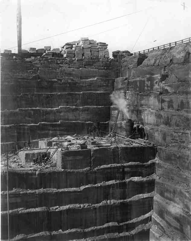
Amherst's Quarries
Is Amherst really the "Sandstone Center of the World?" In fact, it is, but it should share its title with…
Home Sweet Home Model, 1924
While Van Sweringen interests did not guide the development of the South Moreland neighborhood, they did acquire lands…

Dr. Erastus Cushing Home, circa 1851
He was a Massachusetts physician who migrated to Cleveland in 1835. He purchased this house--located on the south side…

Two Family Homes on Hildana Road
The popularity of porches in American architecture peaked between 1880 and 1920. Not only did these open spaces offer a…

The Winslow House
The original Look About Lodge was located in the Cleveland Metroparks South Chagrin Reservation at the intersection of…
