<?xml version="1.0" encoding="UTF-8"?>
<feed xmlns="http://www.w3.org/2005/Atom">
  <title type="text">Cleveland Historical</title>
  <updated>2026-04-17T12:32:22+00:00</updated>
  <generator uri="http://framework.zend.com" version="1.12.20">Zend_Feed_Writer</generator>
  <link rel="alternate" type="text/html" href="https://clevelandhistorical.org/"/>
  <link rel="self" type="application/atom+xml" href="https://clevelandhistorical.org/items/browse?output=rss2"/>
  <id>https://clevelandhistorical.org/</id>
  <author>
    <name>Cleveland Historical</name>
    <uri>https://clevelandhistorical.org</uri>
  </author>
  <link rel="hub" href="http://pubsubhubbub.appspot.com/"/>
  <entry>
    <title type="html"><![CDATA[St. Mary Cemetery: Cleveland&#039;s First West Side Catholic Cemetery]]></title>
    <summary type="html"><![CDATA[<p><strong><em>St. Mary Cemetery lies in the middle of one of the most densely populated residential areas on Cleveland's west side. Its nine acres of land, dotted with shade trees and beautiful grave stones, is surrounded by a fence, and, at its West 41st Street entrance, a posted sign advises visitors of its visiting hours.  However, neither this entrance nor its other on West 38th is gated. This being the case, St. Mary's almost beckons to neighbors and any other passersby to  visit it at any time, day or night, enjoy its grassy grounds, walk its pretty paths, and, most importantly, respect its magnificent  monuments.</em></strong></p><img src="https://clevelandhistorical.org/files/fullsize/1cc9a1a467673d53392c76e36c48e8e6.jpg" alt="The once ornate West 41st Street entranceway to St. Mary Cemetery." /><br/><p>In 1853, just one year before Ohio City was annexed to the City of Cleveland, thus becoming Cleveland's west side, prolific nineteenth-century real estate developer Hiram Stone platted a new residential subdivision south of Ohio City in Brooklyn Township. He called it "H. Stone's Addition to Ohio City & Cleveland," a remarkably prescient title at the time. The new subdivision stretched west from Pearl (West 25th) Street all the way to Gauge (West 44th) Street, and from Clark Avenue north to <a href="https://clevelandhistorical.org/items/show/659">Walworth Run</a> at Ohio City's southern boundary. </p><p>The platted area contained almost 700 lots for residential houses, but left undeveloped in its midst were thirteen acres located just east of Burton (West 41st) Street and north of Clark Avenue. In 1861, as houses were going up in Stone's subdivision—many of them for German immigrants who were pouring into Cleveland in this period in large numbers—the southernmost six acres of the undeveloped thirteen in the middle of the subdivision were purchased by the Catholic Diocese of Cleveland for, according to the deed of purchase, "cemetery purposes for the benefit of German Catholics on the west side of the Cuyahoga River." </p><p>Many of the early records of St. Mary Cemetery appear to have been destroyed in a fire, making research of the early years of the cemetery difficult.  However, secondary sources tell us that St. Mary Cemetery was established on those six acres of land in 1862 by St. Mary of the Assumption parish, Cleveland's first west side German Catholic parish. The property for St. Mary Cemetery was purchased during the pastorship of Father F. X. Obermueller, a German immigrant, but it appears that it was under a subsequent pastor, Father Stephen Falk, a Swiss immigrant who served the parish from 1862 to 1880, that the cemetery grounds were developed and consecrated. In St. Mary Cemetery's early years, it was often referred to as Burton Street Cemetery, after the street upon which it fronted. That street, in turn, had been named after <a href="https://clevelandhistorical.org/items/show/660">William Burton</a>, an Ohio City pioneer whose summer cottage was built on the street in 1839 and still stands directly across from St. Mary Cemetery.  </p><p>Just a few years after St. Mary Cemetery opened, another German Catholic parish, <a href="https://clevelandhistorical.org/items/show/649">St. Stephen</a>, was established on Cleveland's west side. It began in 1869 as a mission of St. Mary of the Assumption for German Catholics living west of Gauge (West 44th) Street. A decade later, in 1881, another parish, <a href="https://clevelandhistorical.org/items/show/717">St. Michael Archangel</a>, was also founded as a mission of St. Mary's for German Catholics living on Cleveland's southwest side. In the years that followed, German Catholics who belonged to either St. Mary of the Assumption, St. Stephen or St. Michael's parishes were permitted to be buried at St. Mary Cemetery which, by this date, had now become part of Cleveland's west side following the 1867 annexation of an area of Brooklyn Township that included the lands upon which the cemetery was located.</p><p>It is interesting to note that no Cleveland newspaper mentioned St. Mary Cemetery during the first decade of its existence. The first to mention the cemetery, albeit obscurely, was the Plain Dealer on May 30, 1871, when it published an article which noted that, on Decoration Day, Father Falk of St. Mary's German church had, at the west side "Catholic cemetery," decorated the graves of "J. Mayer, J. Schneider, F. Werz, A. Klein, K. Mecil, B. Lais, F. Schwonger, S. Vochatger, C. A. Schmidt, and Jas. Macklin." All of these men presumably were German Catholics who had fought for the Union—and for which some had died—in America's Civil War. Cleveland city directories were even slower in acknowledging the existence of the new cemetery. St. Mary Cemetery was not listed in any Cleveland directory until 1874.</p><p>Thousands of German immigrants and descendants of German immigrants were buried at St. Mary Cemetery in the years that followed its establishment, many of them beneath beautiful gravestones inscribed in the German language. A number of these gravestones are memorials to notable German Catholics who, in the second half of the nineteenth century, operated successful retail businesses on Lorain Avenue near Fulton Road, an intersection that soon became known as <a href="https://clevelandhistorical.org/items/show/966">Lorain-Fulton Square</a>. A number of those gravestones honor members of the related Fridrich and Schmitt families who operated several different businesses in that west side commercial district, including <a href="https://clevelandhistorical.org/items/show/964">Fridrich Bicycle</a>, one of the oldest retail bicycle shops in the United States until it closed its doors in 2024. </p><p>Another example of a notable German immigrant businessman buried at St. Mary Cemetery is Friedlin "Freddie" Hirz (1843-1903), a tailor who for years had a shop on Lorain Avenue, just west of what is today West 45th Street. His shop was so well known that it was featured in the 1874 Atlas of Cuyahoga County. Another is Edward Disler, a German immigrant and jeweler who successfully operated a store on Lorain Avenue near West 25th Street for many years.</p><p>While St. Mary Cemetery was explicitly founded for German Catholic burials, Catholics of other ethnicities were later given permission to bury their dead there too. The first of these were Bohemian Catholics many of whom lived near the cemetery in a west side neighborhood that was known in the second half of the nineteenth century as the <a href="https://clevelandhistorical.org/items/show/646">Isle of Cuba</a>. The early-arriving immigrants likely first worshiped with German Catholics at either St. Mary of the Assumption or St. Stephen, but, by 1872, their numbers were sufficiently large that the Bishop permitted them to form a parish of their own, which they called <a href="https://clevelandhistorical.org/items/show/661">St. Procop</a>, after Bohemia's patron saint. Their first church was built on Burton Street, just south of St. Mary Cemetery in 1874. One of the earliest verifiable burials of a Bohemian Catholic at St. Mary Cemetery occurred in 1892, when 41-year- old Miloslav Holecek, a Cleveland grocer and immigrant from <span>Karlova Huť in Central Bohemia</span>, died and was buried there. His gravestone, as well as those for a number of other Bohemian immigrants buried at St. Mary's, is inscribed entirely in the Czech language.</p><p>In the early years of the twentieth century, Catholic immigrants of other ethnic groups from Central Europe who often tended to settle in urban areas where Germans and/or Bohemians had first settled, including Hungarians, Poles, and Slovaks, became members of the west side German and Bohemian Catholic parishes, and when they died, they were permitted to be buried at St. Mary Cemetery too. Their gravestones were often inscribed in their native languages.</p><p>In 1917, Father Casimer Reichlin, the first pastor of St. Stephen who had served for an incredible 47 years, died.  By this time, there appears to have already been a large circular section near the West 41st Street entrance to St. Mary Cemetery, in the center of which a large cross had been erected. It further appears that it was decided that this beloved pastor should be buried in that section, with a large sculpted monument erected over his grave. Four years later, Father Reichlin's long-time friend and fellow priest, Bishop Joseph Koudelka, who had been a pastor at both St. Procop and St. Michael, died and was buried next to Father Reichlin's grave in the circular section. A similarly sized sculpted monument was placed over his grave too. Soon this circular section of St. Mary Cemetery became known as the Priests Circle. In the years that followed, other notable local priests who had served west side Catholic parishes were accorded the same honor and buried in the Priests Circle, some below large monuments and others below simple flat grave markers. As of October 2025, there were eleven priests buried in the Priests Circle. Father Stephen Falk, whose efforts led to the development of the cemetery and its consecration in 1862, is not buried in the Circle, as he died in 1899 long before the Priests Circle was initiated. A simple flat grave marker in Father Falk's memory, which apparently replaced a more elaborate earlier monument, is located in another section of St. Mary Cemetery.</p><p>By the early 1920s, there were few available burial plots left at St. Mary Cemetery. The parish of St. Mary of the Assumption decided to remedy this by expanding the cemetery's lands, and in 1927 and 1928 it successfully purchased three additional acres of land for the cemetery that abutted the eastern end of the original cemetery grounds.  The additional acres had earlier been developed as residential lots in H. Stone's Additional Subdivision. Houses on the lots were either torn down or moved, and the cemetery grounds were successfully extended all the way to West 38th Street. Along with the additional land, St. Mary Cemetery was further enhanced at this time with a second entrance on West 38th Street and a new walking path that led from that entrance directly to a new circular section in the cemetery.</p><p>On November 15, 1931, the new addition to St. Mary Cemetery was consecrated at a ceremony attended by a representative of Bishop Joseph Schrembs.  Some five years later, on May 17, 1936, the Cuyahoga County Council of the Veterans of Foreign Wars placed a flagpole and a memorial plaque in the center of the new circular section, the plaque inscribed: "Dedicated To The Veterans Who Served . . . Lived . . . Died . . . for their Country."  </p><p>As previously noted, St. Mary Cemetery had long held the graves of a number of German Catholic soldiers who fought and died in the Civil War, and also likely holds graves of soldiers and veterans who had fought in the Spanish-American War and/or in World War I. No veterans from any of these war, however, are buried in this new circular section. The first soldier buried in what became known as the Soldiers Circle, was Charles L. Andrews, a U. S. Navy radio operator who was killed on Easter Sunday, April 5, 1942, during the Battle of Bataan in the Philippine Islands. The remains of sixteen other soldiers or veterans who served in World War II were also buried in the Circle between 1942 and 1948.</p><p>In 1945, as a result of dwindling attendance numbers, St. Mary of the Assumption parish was dissolved and, in 1948, the management, care and maintenance of St. Mary Cemetery was transferred to the Calvary Cemetery Association, an organization which was later renamed the Catholic Cemeteries Association of the Cleveland Diocese. By the early 1950s, the last of the available lots in the cemetery were purchased, and, by 1976, according to a January 21, 1976 Plain Dealer article, the number of annual burials at St. Mary Cemetery had dropped to just fifty.  Today, in 2025, the annual numbers appear to be considerably less. According to findagrave.com—a website at which volunteers create memorials for people whose remains have been buried in cemeteries all around the world—the remains of only nine deceased persons have been buried at St. Mary Cemetery since 2020.  </p><p>
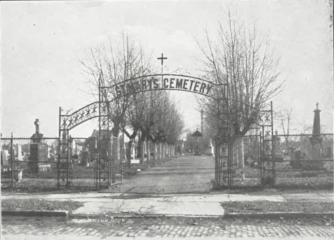
St. Mary Cemetery is no longer the active burial place for west side Catholics that it once was. Burials are now few and far between. The cemetery's elaborate gate that once stood at its West 41st Street entrance in 1929 is gone. The sacred monuments to Father Reichlin, Bishop Koudelka and Father Falk have been substantially damaged, likely by vandals. The cross in the middle of the Priests Circle, which stood there for years until recently, is now gone. Acts of vandalism, as noted in a number of Plain Dealer and Press articles over the years, and the effects of exposure of the cemetery's monuments to Cleveland's weather over long periods of time, have left many monuments damaged and unreadable while many others have simply vanished. Still, St. Mary Cemetery remains one of the most historic cemeteries on Cleveland's west side and one which should be visited, respected, and carefully managed and maintained, not only for the descendants whose ancestors are buried there, but also for all Clevelanders who see value in preserving an important piece of their city's history.</p><p><em><strong><a href="https://clevelandhistorical.org/items/show/1072">For more (including 15 images) view the original article</a></strong></em></p>]]></summary>
    <published>2025-11-23T16:18:32+00:00</published>
    <updated>2026-03-04T21:32:06+00:00</updated>
    <link rel="alternate" type="text/html" href="https://clevelandhistorical.org/items/show/1072"/>
    <id>https://clevelandhistorical.org/items/show/1072</id>
    <author>
      <name>Jim Dubelko</name>
    </author>
  </entry>
  <entry>
    <title type="html"><![CDATA[Ohio City (City of Ohio): Building the West Side&#039;s First Urban Community]]></title>
    <summary type="html"><![CDATA[<p><strong><em>While other early New England settlers in Brooklyn Township envisioned growing acres of corn and building a rural community, Josiah Barber, a Connecticut native who arrived there in 1818, saw an entirely different future for the township located on the west bank of the Cuyahoga River.  </em></strong></p><img src="https://clevelandhistorical.org/files/fullsize/caf053b72e7b782e5758cb554344b381.jpg" alt="Charles Winslow House" /><br/><p>Josiah Barber might have never set foot in Ohio if his first wife, Abigail Gilbert, hadn't died in 1797, leaving him with a young daughter to raise. In 1802, he married Sophia Lord of East Haddam, Connecticut, and, in doing so, became a member of the prominent Lord family. Several years later, after his new father-in-law had purchased nearly all of the land in what would become Brooklyn Township, Josiah became a partner in the family business of selling land in the new township. </p><p>In 1818, he and his wife and four children moved to Brooklyn township, where he organized the first township government and then laid out the first village lot development. While the survey of this village, which included a public square probably not unlike that in the village of Cleveland, appears to no longer exist, county deed records suggest that the approximate village boundaries were Detroit Avenue on the north, West 28th Street on the west, the Cuyahoga River on the east, and Monroe Avenue on the south. </p><p>The first village lots were sold in 1820 and the village soon became known as Brooklyn. In the same year that village development on the west bank began, Barber and Noble Merwin, who owned land across the river, obtained a license from the Ohio Legislature to build a permanent bridge across the Cuyahoga River. However, the demand for village lots in the 1820s turned out to be not sufficient to justify the expense of building that bridge, and the two men, probably wisely, allowed their license to expire. In the decade that followed, that would all change. </p><p>As a result of the building of the Ohio-Erie Canal (1825-1834), land speculation fever hit northeast Ohio in the early 1830s. The first investors to seize the opportunity that presented itself on the west bank were two Cleveland merchant bankers, Charles Gidding and Norman C. Baldwin, who were capitalized by a group of investors from Buffalo led by <a href="https://clevelandhistorical.org/items/show/645">Benjamin F. Tyler</a>, son-in-law of a wealthy judge. </p><p>In 1833, this group--known as the Buffalo Company, purchased Lorenzo Carter's farm and laid out a village on the west side near the mouth of the Cuyahoga River with 52 blocks and 1,100 lots. The development was bounded on the east by the river, on the north by the old river bed, on the south by Detroit Avenue, and on the west by what is today West 28th Street. With its warehouses and docks located in the west flats and its houses and retail shops up on the hill, it soon became known as West Cleveland, or simply West Village. </p><p>Josiah Barber too capitalized on this speculation fever. In 1831, he and his brother-in-law Richard Lord, who had moved to Brooklyn Township in 1826, formed a real estate partnership, and in 1835, they began planning for a redesign and re-subdivision of Brooklyn Village. They replaced the original public square with a circle-- at first called Franklin Place but later Franklin Circle, which featured streets emanating from it like spokes of a wheel, and they greatly increased the number of lots in the subdivision. </p><p>The new village design and development was not altogether different from that of Cleveland Centre on the east side at Oxbow Bend, which had been laid out in 1833 by an investor group led by former county sheriff, James S. Clarke. This group decided to invest also on the west side, and in 1835 purchased land from Barber and Lord east of today's West 25th Street that extended south beyond Lorain Avenue. The group named their new development "Willeyville," after one of their investors, John Willey, who also happened to be the mayor of Cleveland. </p><p>As part of the land purchase, the Clarke group was assigned the new state bridge license that Barber had obtained and undertook an obligation to build a bridge across the Cuyahoga River connecting the nearby developments on both sides of the river. Within the year, the Columbus Street bridge--the first permanent bridge across the river, was built. As the decade continued to unfold, village development in the West Village area also expanded. </p><p>In 1835, Ezekiel Folsom, a partner of Josiah Barber and Richard Lord in the Cuyahoga Steam Furnace Company, purchased 100 acres of the Charles Taylor farm--located immediately to the west of both West Village and Brooklyn Village, and laid out streets and village lots on the north and south sides of Detroit Avenue, pushing the western boundary of village development all the way to Harbor (West 44th) Street. </p><p>In the same year that Folsom began converting Charles Taylor's farm into village lots, community leaders on both sides of the river began openly discussing the need for a city charter to effectively address all of the issues and problems that came with rapid urban growth. Many on the west side--undoubtedly led by Josiah Barber, supported forming a single city on both sides of the river. However, most Clevelanders disagreed, fearing that the new city would be controlled by investors from Buffalo, then a much larger city than Cleveland. </p><p>In the end, separate charters were sought for each side of the river. On March 3, 1836, Ohio City, officially known as the City of Ohio, came into existence. Notable in its charter was the new western boundary line set along the western line of original Brooklyn Township Lot No. 50, which today would be between West 58th and West 59th Streets. </p><p>Josiah Barber, who, more than anyone else, shaped the first urban community on the west bank of the Cuyahoga River, was elected the first mayor of Ohio City in 1836. He served only one one-year term and died just five years after that in 1842, more than a decade before the annexation of Ohio City to the City of Cleveland in 1854. </p><p>Josiah Barber also didn't live to seen one last territorial change for the historic first city on the west bank. In 1853, one year before the City of Ohio was annexed to Cleveland, its voters approved an annexation proposal that, among other things, extended the western territorial limits of the city all the way to Alger (West 67th) Street. Given the efforts that Josiah Barber had made to establish this west side urban community and to then literally build a bridge between it and Cleveland on the east bank of the river, both annexations would likely have been events that he would have celebrated heartily.</p><p><em><strong><a href="https://clevelandhistorical.org/items/show/765">For more (including 15 images) view the original article</a></strong></em></p>]]></summary>
    <published>2016-05-15T21:27:25+00:00</published>
    <updated>2026-03-04T21:32:03+00:00</updated>
    <link rel="alternate" type="text/html" href="https://clevelandhistorical.org/items/show/765"/>
    <id>https://clevelandhistorical.org/items/show/765</id>
    <author>
      <name>Jim Dubelko</name>
    </author>
  </entry>
  <entry>
    <title type="html"><![CDATA[William Burton House: The Historic West Side House That Changed as Its Owners Changed]]></title>
    <summary type="html"><![CDATA[<img src="https://clevelandhistorical.org/files/fullsize/b38fba8d148bdfb0401d252c156d4eab.jpg" alt="The Burton House" /><br/><p>In his book "How Buildings Learn: What Happens After They're Built," Stewart Brand explores the relationship between people and the structures they create.  Referring to Winston Churchill's statement that "We shape our buildings, and afterwards our buildings shape us," Brand writes that Churchill almost got it right.    More accurately, says Brand, "First we shape our buildings, then they shape us, then we shape them again--ad infinitum.  Function reforms form, perpetually."</p><p>The Burton House at 2678 West 41st Street illustrates Brand's point almost perfectly.  Built in 1839 by William Burton, a ship captain from Vermont and early Ohio City pioneer, it is one of the oldest, if not the oldest, homes in Cleveland's Clark-Fulton neighborhood. In the 175 years of its existence, it has changed from elitist country home to middle-class neighborhood home to working-class residence in a struggling community and, now, to abandoned home in a neighborhood that is perhaps on its way to rebirth.  And along the way, the house has shaped the lives of all of the people who have owned and lived in it, just as they have shaped and reshaped it.</p><p>Originally located on thirty acres of land just south of Walworth Run in what was at the time Brooklyn Township, the house was once referred to by Burton's mother-in-law as his "Ohio City cottage."  While it is a small house by mansion standards, it was clearly designed for upper class living.  When first occupied, it had a large parlor and dining room on the first floor with nearby servant's quarters which had easy access to those two rooms, as well as to the pantry and small servant's kitchen.  On the second floor were the family bedrooms.  The house was nestled among vineyards and apple, peach and other fruit trees.  </p><p>Change came to the house in 1854 when Burton sold most of his thirty acres of land to Hiram Stone, a local land developer.  Stone incorporated the house into a large residential subdivision that he was building and named the county road upon which the house sat "Burton Street" for William Burton.  Stone's subdivision would soon become the newest addition to Cleveland's south side.  </p><p>In 1861, English immigrant George Howlett bought the Burton House which now sat on an approximately one-half acre parcel of land, but still had almost 130 feet of frontage on Burton (today, West 41st) Street.  Howlett saw the neighborhood changing as German and Bohemian immigrants moved in and as industry sprung up along the Walworth Run.  He responded by changing the house.  He removed the house's south wing and subdivided the land upon which the house sat into five lots and an alley, leaving the now less grand-looking Burton House sitting on a thirty-three foot wide strip of land sandwiched between and dwarfed by two newer houses that were built closer to the street.  He also relocated and enlarged what was now a family kitchen, built a cellar, and added a  storage shed and lean to to the back of the house.  When, after almost four decades of ownership,  the Howlett family sold the Burton House in 1899, it no longer was that original elitist country home.  It had become, like its most recent owner, middle class.</p><p>The process of owners changing the Burton house, and the Burton house changing owners, continued into and through the next century.  In the early twentieth century, the home was first owned by a family who added an indoor bathroom—that new century convenience, and removed the shed and lean to,  presumably to make room on the property for another new century convenience, the automobile.</p><p>The twentieth century also brought a wave of new immigrants to Cleveland and to the Clark-Fulton neighborhood. Along the Fulton Road corridor, an Italian community grew, which, in 1915, founded St. Rocco parish.  In 1944, the Burton House was acquired by an Italian family who owned and lived in it for most of the remainder of the century. As Cleveland experienced decline in the second half of the century, so did the Clark-Fulton neighborhood, and so did the Burton House. Now located in a working class neighborhood, the house again changed with its new owners.  Another bathroom was added. The servant's quarters became family bedrooms.  The pass-through from the pantry to dining room was plastered over.  Upstairs bedrooms were rented out to boarders to help make ends meet.       </p><p>With help from Cleveland's Department of Community Development in the 1980s, the Burton House was maintained in livable condition until it was sold in 1997. After that, it rapidly deteriorated. Its beautiful exterior French doors were removed and sold.  So was the chandelier which once adorned the dining room. The late Cleveland Municipal Court Judge Ray Pianka spent countless hours working with Clark-Fulton neighborhood community leaders in a never-give-up effort to save the house.  While regrettably he did not live to see it happen, the William Burton House was eventually rescued, renovated and restored in 2021. In less than two decades, this historic house will celebrate its 200th anniversary on West 41st Street.</p><p><em><strong><a href="https://clevelandhistorical.org/items/show/660">For more (including 14 images) view the original article</a></strong></em></p>]]></summary>
    <published>2014-05-31T13:44:20+00:00</published>
    <updated>2026-03-04T21:32:02+00:00</updated>
    <link rel="alternate" type="text/html" href="https://clevelandhistorical.org/items/show/660"/>
    <id>https://clevelandhistorical.org/items/show/660</id>
    <author>
      <name>Jim Dubelko</name>
    </author>
  </entry>
  <entry>
    <title type="html"><![CDATA[Where in the World is Walworth Run?: Bridged, Culverted, Sewered and Today Largely Forgotten]]></title>
    <summary type="html"><![CDATA[<img src="https://clevelandhistorical.org/files/fullsize/67080c6cc40724b4a410bdb04d67e1d5.jpg" alt="Industry and Nature Appearing in Harmony" /><br/><p>For a long time, it was part of the most prominent geographical feature of the west side of Cleveland. A pleasant little winding brook, the Walworth Run had its headwaters near what is today the intersection of Clark Avenue and West 65th Street. It flowed from there northeasterly to the Cuyahoga River, a distance of about three miles. The valley through which it passed was wide, with hillsides that became so steep as they neared the Cuyahoga River, that they formed a natural boundary between what came to be known as the west and south sides of town. </p><p>Walworth Run was reputedly named after pioneer settler Judge John Walworth, who lived in Cleveland for just six years before his untimely death in 1812. When Walworth died, the Run was still that pleasant little brook. But two decades later that began to change. The Ohio & Erie Canal was built. Industry began to come to Cleveland. And with industry came thousands of migrants and immigrants. And then, sometimes in concert, other times at odds, local government, industry, and new residents threatened, endangered and finally ended the existence of Walworth Run.</p><p>Culverts and bridges built over it by the city on occasion collapsed, or were washed away in storms, spilling stones, iron, and other materials into it. Slaughterhouses, breweries and oil refineries, which located along the Run near the Big Four railroad tracks, used it as an open sewer for their industrial waste. Residents did much the same, dumping down the hillsides and into the Run everything from table scraps to ashes to tin cans to broken glass. To alleviate flooding in the <a href="https://clevelandhistorical.org/items/show/646">Isle of Cuba</a>, the west side Czech community located just south of the Run, the City built storm sewers that channeled rain water into it. Eventually, the Walworth Run became so swollen and polluted that, by the early 1870s, nearby residents, whose lands had by this time been annexed to the City of Cleveland, were clamoring for City Hall to do something about it.</p><p>George Howlett, a professional painter and immigrant from England, was one of those residents. He knew the Walworth Run well. In 1850, when he was just 25 year old, he and his wife Sarah moved from Cleveland, crossing the Cuyahoga River to become residents of what was then still Brooklyn Township. In 1861, he purchased the old <a href="https://clevelandhistorical.org/items/show/660">William Burton House</a> at 221 Burton Street (today, 2678 West 41st Street). The Greek Revival styled house sat (and still does today) less than a half mile south of Walworth Run. George regularly took walks along the Run, enjoying its beauty and country-like feel. As much as anyone else, he was an eyewitness to the transformation of the picturesque brook into a foul-smelling, litter-clogged dank body of water. </p><p>In August 1873, after the area had been annexed to Cleveland, a group of residents met with the City Board of Health. In this era, the science of bacteriology was still in its infancy and many still believed that the odors from such a polluted waterway could cause fatal diseases if inhaled. When the Board appeared to be unresponsive to their fears and complaints, they marched over to Becker Hall at the corner of Columbus (West 25th) Street and Queen Avenue to organize. The radicals wanted to press the city to evict all slaughterhouses from the Run. George Howlett, who had been elected secretary, convinced them to instead petition the City to abate the nuisance by enclosing the entire Walworth Run—all nearly three miles of it, in an underground sewer. </p><p>For the two decades that followed, Cleveland City officials deliberated, delayed and sometimes battled in court with residents and other interested parties, over just how to construct such a sewer and, just as importantly, how to pay for it. While George Howlett, who died in 1892, never lived to see it, the matter was finally resolved in 1897 when the City commenced construction of the Walworth Run Sewer. It was an engineering marvel and then the largest sewer project ever undertaken by the City of Cleveland. The diameter of the pipe in much of the sewer was more than 16 feet—large enough for a locomotive to pass through it. It was designed to separate sewage from storm water, sending the former into an interceptor pipe that emptied into Lake Erie, while the latter was transported along a separate chamber into the Cuyahoga River. Completed in 1903, the project eliminated the Walworth Run as a geographical feature of the west side of Cleveland, replacing it with a sewer and atop that a street that bore the Run's name. </p><p>Today, more than 100 years later, the Walworth Run Sewer is still here. It is an integral part of the Northeast Ohio Regional Sewer District sewer system for the west side of Cleveland. Some of Walworth Avenue too still remains, although parts have been vacated and other parts have been renamed Train Avenue. But that pleasant little winding brook called Walworth Run that once flowed northeasterly into the Cuyahoga River separating Cleveland's west and south sides? It has been gone for so long that most Clevelanders have forgotten that it ever even existed.</p><p><em><strong><a href="https://clevelandhistorical.org/items/show/659">For more (including 12 images) view the original article</a></strong></em></p>]]></summary>
    <published>2014-05-17T11:35:30+00:00</published>
    <updated>2026-03-04T21:32:02+00:00</updated>
    <link rel="alternate" type="text/html" href="https://clevelandhistorical.org/items/show/659"/>
    <id>https://clevelandhistorical.org/items/show/659</id>
    <author>
      <name>Jim Dubelko</name>
    </author>
  </entry>
</feed>
