Duck Island

Duck Island has nothing whatsoever to do with ducks (although you may see an occasional duck sign or banner). Most folks believe that Duck Island got its name during Prohibition—a place where bootleggers would “duck” the law.
Even people who live nearby may not know about Duck Island. Among suburbanites, the name is even less likely to resonate. What’s more, if you do a Google Images search you’ll get pretty pictures of an island off the cost of Maine. Some of these photos include ducks, but none of them are Cleveland’s Duck Island.
So where is Duck Island and what does it have to do with ducks? The answer to the first question is that Duck Island is a small community (perhaps one square mile) between Tremont and Ohio City. Bisected by Abbey Avenue, Duck Island is bordered by Carnegie Avenue to the north, Train Avenue and Scranton Road to the south and east, and the RTA Red Line rapid tracks to the west. For municipal planning and management purposes, Duck Island is considered part of Tremont. The answer to the second question is that Duck Island has nothing whatsoever to do with ducks (although you may see an occasional duck sign or banner). Most folks believe that Duck Island got its name during Prohibition—a place where bootleggers would “duck” the law.
But Duck Island’s profile is rising rapidly. In fact, it might be hard to find a Cleveland locale whose popularity has increased more swiftly. Plans are underway for large “ultra green” housing developments at West 20th and Lorain; West 20th and Abbey; and West 19th and Freeman. Toney new homes dot Columbus Road and West 17th, 18th and 19th Streets. Abbey Park, located at the corner of West 19th Street and Smith Court is earmarked for a major facelift. Gateway Clinic on Abbey Avenue has become a haven for quality pet care. Several new breweries are on the books. And to the cheers of myriad residents, St. Wendelin Catholic Church on Columbus Road reopened its doors in 2012—two years after being closed by the Catholic Dioceses of Cleveland.
To be sure, a number of residents are squeamish about Duck Island’s burgeoning popularity. Concerns about inflation, noise, parking and population density are common and largely valid. Fortunately, organizations like Tremont West Development Corporation, the Duck Island Block Club, the Duck Island Development Collaborative, Cleveland Neighborhood Progress and Kent State University’s Cleveland Urban Design Collaborative are working hard to build figurative bridges. That’s a good thing because Duck Island has become too hot to not trot: It’s equidistant between Tremont and Ohio City; a short drive, train ride or walk to downtown; and a hop/skip/jump to riverfront destinations like the Towpath Trail, Scranton Peninsula and Merwin’s Wharf. Plus it has killer views of the city.
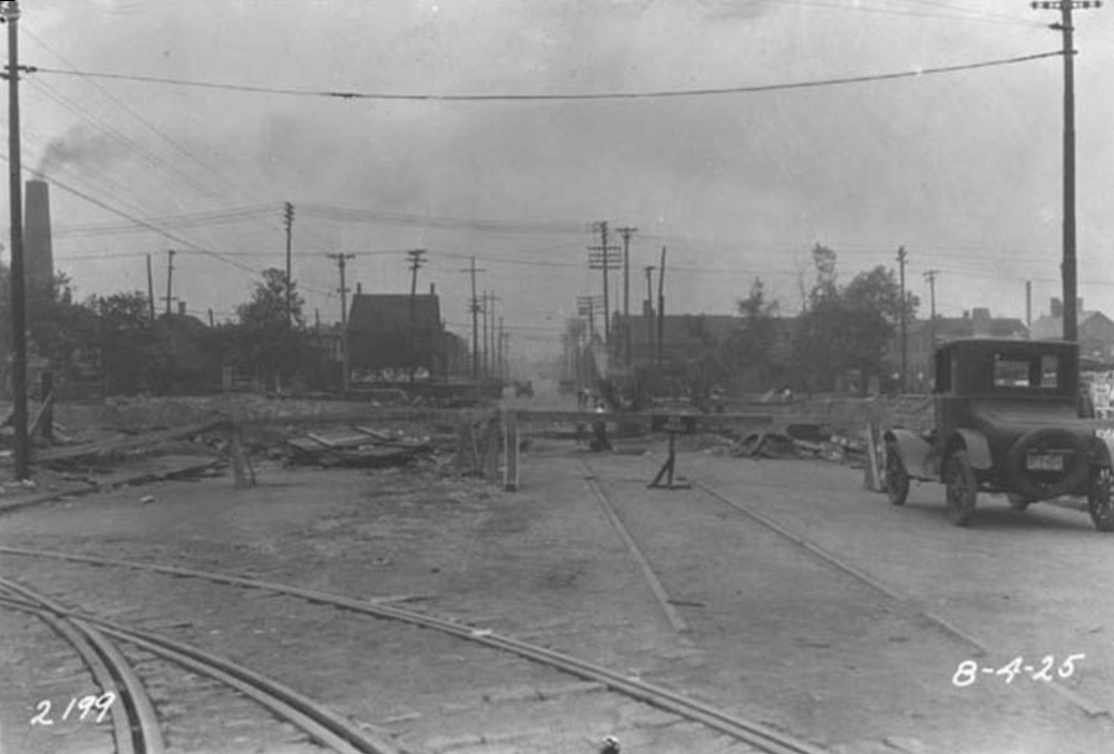
Like Tremont and Ohio City, Duck Island is an old neighborhood. Most of its original housing stock dates to the late 1800s. These homes were inhabited primarily by blue-collar workers who staffed steel mills, factories, warehouses and river-shipping interests in the Flats. In fact, the geography of Duck Island is such that, until the early 20th Century, Tremont residents could not walk north or east without first descending into the Flats. In 1887, however, the Central Viaduct, was constructed. Initially, the Viaduct consisted of two bridges: The first structure (more than one-half-mile long) extended from Jennings Ave. (now West 14th Street) to Central Avenue (now Carnegie Avenue). It followed the same basic path taken by what is now Interstate 90. Deemed unsafe, the bridge was torn down in the early 1940s. The second structure—the Abbey Avenue Bridge—continues to bind Tremont and Ohio City, with Duck Island smack in the middle.
Even with the bridges, Duck Island retained most of its isolated, blue collar status throughout the 20th Century. That sense of sequestration was exacerbated by the fact that, over the years, Duck Island was alternately claimed and disowned by Ohio City and Tremont. In the mid 1920s, moreover, Duck Island became even more isolated on the west when a deep trench was dug to accommodate railroad tracks for passenger trains serving the new Union Terminal complex. A half-dozen city blocks were removed—thus separating Duck Island from Ohio City. The only bridge subsequently erected to cross the divide was on Abbey Avenue.
Beginning in the 1970s, populations declined precipitously throughout the area. Businesses closed and even fewer people than usual wanted to move to a disadvantaged neighborhood with elderly housing stock and close proximity to a downtown with little to offer. However, Duck Island might have been rediscovered sooner, were it not for residents’ extreme suspicions about redevelopment. This mindset peaked in the 1990s, when residents staunchly opposed any initiatives that smelled even vaguely of gentrification. Rosemary Vinci, a community leader with a frequently ambiguous agenda, urged residents to reduce density by acquiring neighboring properties and demolishing dwellings. Vinci was a former strip club manager who, at the time of her death in 2008, was being investigated alongside her superiors, Jimmy Dimora and Frank Russo. Vinci also led opposition to a development next to the West 25th Street Station along Columbus Road south of Lorain. Rosemary’s father, by the way, was James Vinci, reputed organized crime figure and owner of the famed Diamond Jim's in the Flats.
Vinci or no Vinci, change is coming to Duck Island, including the kind of mixed-income, high-density residential development Rosemary so vociferously opposed. The plusses and minuses of urban renaissance will continue to be debated, but Duck Island’s unified wall of resistance is beginning to quack.
Images