Filed Under Agriculture

East Cleveland Township Farms

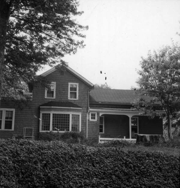
Although it is hard to imagine, Cleveland Heights was once covered in towering trees, large farms, quarries and vineyards. While people moved from the City of Cleveland into other adjacent areas in the 1830s and 1840s, Cleveland Heights remained fairly undeveloped until the turn of the 20th century, partially due to its remote location at the top of a bluff. A 1903 map of East Cleveland Township (out of which grew Cleveland Heights) shows just eight roads, with most of the land divided into large parcels and farms. Mayfield Road opened in 1828 as a six-foot-wide dirt road. Conversion to a plank toll road in 1877 encouraged both an increase in commerce and emigration to the area by farmers and quarry workers. Connected to Mayfield Road, Euclid Avenue and the railroad lines, Noble Road was one of the earliest streets in Cleveland Heights. However, Noble's distance from the streetcar lines and developments in the southern areas ensured that the street remained relatively undeveloped into the 1920s. Evidence of the rural history of the northern half of Cleveland Heights can be found in the early farm homes that still stand on or near Noble Road. The early settlers of the northern half of Cleveland Heights were mostly farmers and workers at the Bluestone Quarry. Many, like William Quilliams (whose house still stands at 884 Quilliams Road), went on to become leaders in the growing community of Cleveland Heights. Other pioneers went in different directions. In 1851, Asa and Teresa Cady (whose home can be seen at 3921-23 Bluestone Road) were among the 14 members of the First Presbyterian Church of Collamer who broke their connection with that church because it "maintained fellowship with slaveholders." Mr. Cady served as vice president of the Cuyahoga Anti-Slavery Society and the home was long rumored to be a stop on the Underground Railroad. While Cleveland Heights has changed dramatically over the last 100 years, these homes serve as reminders of a more rural past. The City of Cleveland Heights has designated several as Landmarks, recognizing their importance to our community's heritage.

Images

Underground RR Stop?
Underground RR Stop? The Asa Cady House at 3921-23 Bluestone Road is reputed to have been moved from its original location near Noble and Monticello, where it was associated with a steam-powered sawmill that probably cut bluestone quarried nearby. Because of Asa Cady's involvement in the Cuyahoga County Anti-Slavery Society, some believe this home was part of the Underground Railroad. Creator: Mazie Adams
Mayfield Road, 1902
Mayfield Road, 1902 The development of Mayfield Road encouraged the settlement of the northern half of Cleveland Heights. Source: Mary Emma Harris and Ruth Mills Robinson, Proud Heritage of Cleveland Heights (1966)
William Quilliams House
William Quilliams House Hugh Quilliams built this farmhouse at 884 Quilliams Road in 1867 for his son and daughter-in-law, William T. and Nancy Quilliams. A carpenter and Union Army veteran, William went on to become a civic leader, serving as a trustee for East Cleveland Township and later for the hamlet of Cleveland Heights. The family capitalized on the real estate boom in the early 20th century and developed their property into many of the streets in the Oxford neighborhood. The home has been altered significantly, although the wooded property is a reminder of its more rural beginnings. Source: City of Cleveland Heights
Willard Wight House
Willard Wight House Willard Wight, and later his son Hiram, lived and worked in this 1851 farmhouse, situated on 52 acres of land. The farm was sold in 1907 and subdivided for a residential development that included Ardmore, Rosemond and Navahoe roads. Originally just one and a half stories, side wings and porch were added later in its history. The house's modern address is 2751 Noble Road. Creator: Mazie Adams
Bluestone Rd., ca. 1930s
Bluestone Rd., ca. 1930s As this photograph suggests, Bluestone Road remained unpaved into the Great Depression years, although it had already filled with suburban development. In rainy weather, it was rutted and pocked with deep puddles. Source: unknown
Mayfield Road Toll Gate, 1902
Mayfield Road Toll Gate, 1902 This small gatehouse stood on the northwest corner of Mayfield and Superior roads. This shot, taken 25 years after the toll road opened, suggests the persisting rural setting in what would soon become the suburban village of Cleveland Heights. Note the small sign on the side of the gatehouse. It reads "Binder Twine for sale here." Source: City of Cleveland Heights

Location

3921 Bluestone Rd, Cleveland Heights, OH 44121 | Private residences

Metadata

Mazie Adams, “East Cleveland Township Farms,” Cleveland Historical, accessed July 27, 2024, https://clevelandhistorical.org/items/show/502.