Fairmount Circle

A Second "University Circle"

In January 1925, the Van Sweringen Company conveyed 113 acres of land to the University Realty Company. The land conveyed was located in in the villages of Shaker Heights and Idlewood--in the vicinity of the intersection of Fairmount Boulevard and Warrensville Center Road. This transfer of land completed a complex real estate deal that created the Fairmount Circle neighborhood. The Van Sweringens believed that this new neighborhood would one day become the Cleveland area's second "University Circle."

The official plat of the Fairmount Circle neighborhood, prepared by Harry Gallimore of the F.A. Pease Engineering Company, featured a prominent traffic circle at the intersection of four roads--Fairmount Boulevard, Warrensville Center Road, North Park Boulevard, and Meadowbrook Boulevard. The traffic circle was designed to have a 900 foot circumference. It was to provide, according to a January 18, 1925 article in the Cleveland Plain Dealer, "eight imposing corner sites" for "artistic buildings."

Fairmount Circle arguably never evolved into the second University Circle that the Van Sweringens believed it would. However, its development did induce several excellent educational institutions to relocate to the Circle neighborhood during the period 1925-1927.

In 1925, John Carroll University (formerly St. Ignatius College) moved from West 30th Street on the near west side of Cleveland to the northeast quadrant of Fairmount Circle located in Idlewood Village. The Village subsequently changed its name to "University Heights" in honor of John Carroll University's new campus. In addition to John Carroll, two old and well-established Cleveland private academies moved to sites on other quadrants of Fairmount Circle that were located in the City of Shaker Heights.

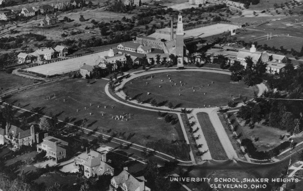
University School, one of the two prestigious academies that moved to Shaker Heights, was founded in 1876 and had been located on Hough Avenue in Cleveland for 50 years. In 1926, University School moved to a new site on a southeast quadrant of Fairmount circle. One year later, in 1927, Hathaway Brown moved to a location on a southwest quadrant of the circle. Hathaway Brown, like University School, was founded in 1876. Before moving to its new Shaker Heights campus, it had been located in Cleveland on East 97th Street near Euclid Avenue.

Today, nearly 90 years later, these three educational institutions still call Fairmount Circle their home. Fairmount Circle remains a pleasant residential neighborhood on the north side of Shaker Heights.

Images

University School, Shaker campus
University School, Shaker campus This undated photo of the University School campus in Shaker Heights shows the main entrance to the school at the intersection of Shaker Boulevard and Warrensville Center Road. Source: Cleveland Memory Project, Cleveland State University Library Special Collections
University School - 1912
University School - 1912 This postcard photograph shows University School as it appeared in 1912 when the school was located in Cleveland near the intersection of Hough and Giddings (East 71st Street) Avenues. Source: Cleveland Memory Project, Cleveland State University Library Special Collections
Hathaway Brown, Shaker Campus
Hathaway Brown, Shaker Campus This 1963 photograph shows several of the primary buildings of Hathaway Brown at its Shaker Campus. Hathaway Brown moved from Cleveland to Fairmount Circle in 1927. Source: Cleveland Memory Project, Cleveland State University Library Special Collections
Crowning a Queen
Crowning a Queen The May Festival, a celebration of spring that has its roots in ancient tradition, was an annual event at Hathaway Brown School for many years. This photograph depicts the crowing of the queen at the school's 1967 May Festival. Source: Cleveland Memory Project, Cleveland State University Library Special Collections
Shaker Estates
Shaker Estates In 1924, the F. A. Pease Engineering Company prepared this map for the Van Sweringen Company. The map shows the new residential subdivision in Shaker Heights that was to be built as part of the Fairmount Circle project. Note that both Fairmount Circle and Hathaway Brown school (which did not relocate to Shaker Heights until 1927) appear on the right side of this map. Source: Cleveland Memory Project, Cleveland State University Library Special Collections
A Road through the Circle
A Road through the Circle In 1964, the Van Sweringens' design of Fairmount Circle was significantly changed when Warrensville Center Road was extended through the Circle to enable northbound and southbound traffic to entirely avoid driving around the Circle. Source: Cleveland Memory Project, Cleveland State University Library Special Collections
Fairmount Circle today
Fairmount Circle today Aerial view of Fairmount Circle as it appears today. A portion of John Carrol University campus can be seen in the upper right part of the photograph, and a portion of the University School campus in the lower right. Note that Warrensville Center Road now extends through the Circle. Source: Google Maps

Location

Fairmount Circle, University Heights, OH

Metadata

Jim Dubelko, “Fairmount Circle,” Cleveland Historical, accessed May 13, 2024, https://clevelandhistorical.org/items/show/417.