Ohio City (City of Ohio)

Building the West Side's First Urban Community

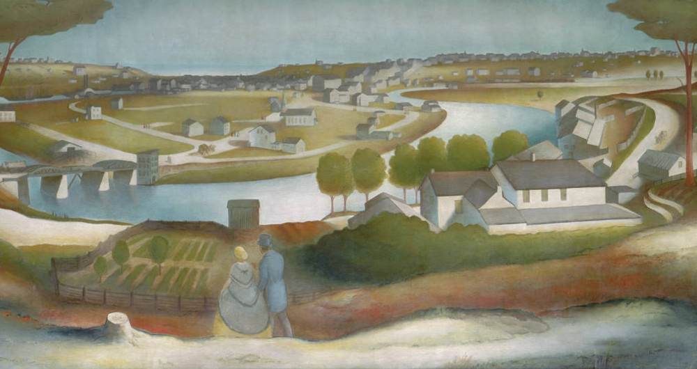
While other early New England settlers in Brooklyn Township envisioned growing acres of corn and building a rural community, Josiah Barber, a Connecticut native who arrived there in 1818, saw an entirely different future for the township located on the west bank of the Cuyahoga River.

Josiah Barber might have never set foot in Ohio if his first wife, Abigail Gilbert, hadn't died in 1797, leaving him with a young daughter to raise. In 1802, he married Sophia Lord of East Haddam, Connecticut, and, in doing so, became a member of the prominent Lord family. Several years later, after his new father-in-law had purchased nearly all of the land in what would become Brooklyn Township, Josiah became a partner in the family business of selling land in the new township. 
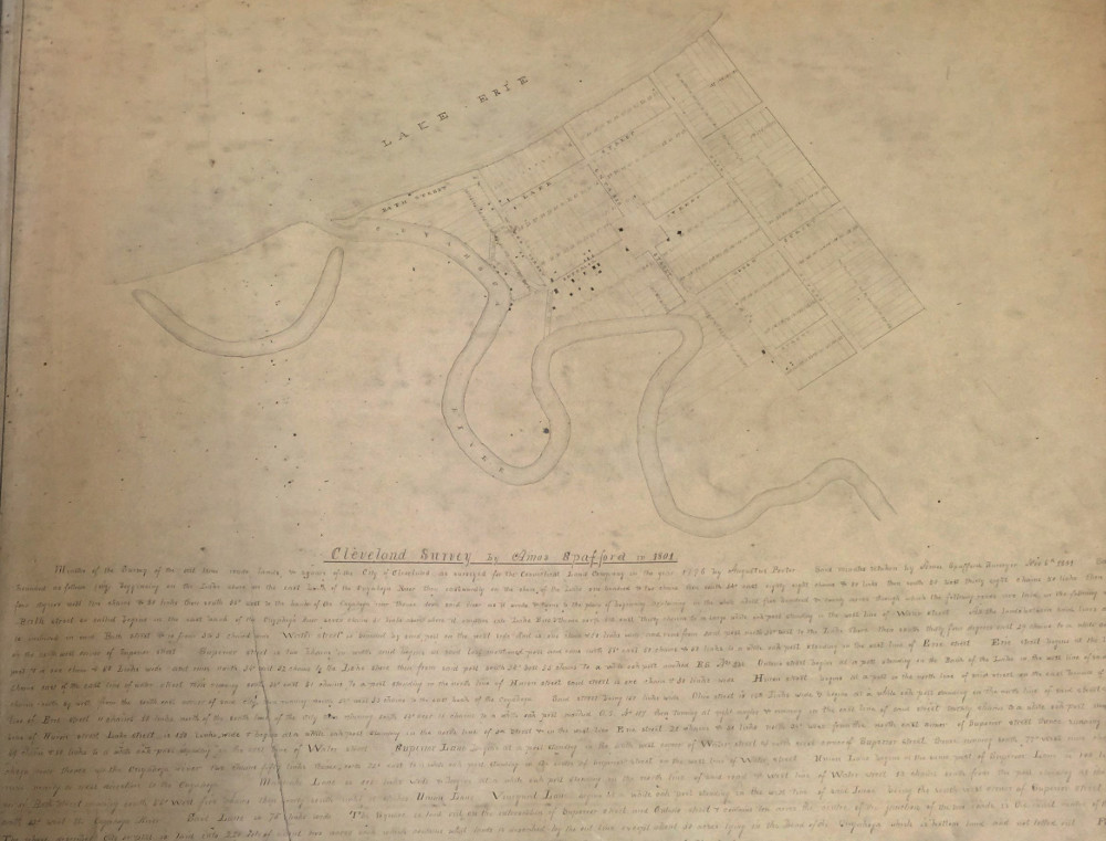
In 1818, he and his wife and four children moved to Brooklyn township, where he organized the first township government and then laid out the first village lot development. While the survey of this village, which included a public square probably not unlike that in the village of Cleveland, appears to no longer exist, county deed records suggest that the approximate village boundaries were Detroit Avenue on the north, West 28th Street on the west, the Cuyahoga River on the east, and Monroe Avenue on the south. The first village lots were sold in 1820 and the village soon became known as Brooklyn.

In the same year that village development on the west bank began, Barber and Noble Merwin, who owned land across the river, obtained a license from the Ohio Legislature to build a permanent bridge across the Cuyahoga River. However, the demand for village lots in the 1820s turned out to be not sufficient to justify the expense of building that bridge, and the two men, probably wisely, allowed their license to expire. In the decade that followed, that would all change.

As a result of the building of the Ohio-Erie Canal (1825-1834), land speculation fever hit northeast Ohio in the early 1830s. The first investors to seize the opportunity that presented itself on the west bank were two Cleveland merchant bankers, Charles Gidding and Norman C. Baldwin, who were capitalized by a group of investors from Buffalo led by Benjamin F. Tyler, son-in-law of a wealthy judge. In 1833, this group--known as the Buffalo Company, purchased Lorenzo Carter's farm and laid out a village on the west side near the mouth of the Cuyahoga River with 52 blocks and 1,100 lots. The development was bounded on the east by the river, on the north by the old river bed, on the south by Detroit Avenue, and on the west by what is today West 28th Street. With its warehouses and docks located in the west flats and its houses and retail shops up on the hill, it soon became known as West Cleveland, or simply West Village.

Josiah Barber too capitalized on this speculation fever. In 1831, he and his brother-in-law Richard Lord, who had moved to Brooklyn Township in 1826, formed a real estate partnership, and in 1835, they began planning for a redesign and re-subdivision of Brooklyn Village. They replaced the original public square with a circle-- at first called Franklin Place but later Franklin Circle, which featured streets emanating from it like spokes of a wheel, and they greatly increased the number of lots in the subdivision. The new village design and development was not altogether different from that of Cleveland Centre on the east side at Oxbow Bend, which had been laid out in 1833 by an investor group led by former county sheriff, James S. Clarke. This group decided to invest also on the west side, and in 1835 purchased land from Barber and Lord east of today's West 25th Street that extended south beyond Lorain Avenue. The group named their new development "Willeyville," after one of their investors, John Willey, who also happened to be the mayor of Cleveland. As part of the land purchase, the Clarke group was assigned the new state bridge license that Barber had obtained and undertook an obligation to build a bridge across the Cuyahoga River connecting the nearby developments on both sides of the river. Within the year, the Columbus Street bridge--the first permanent bridge across the river, was built.

As the decade continued to unfold, village development in the West Village area also expanded. In 1835, Ezekiel Folsom, a partner of Josiah Barber and Richard Lord in the Cuyahoga Steam Furnace Company, purchased 100 acres of the Charles Taylor farm--located immediately to the west of both West Village and Brooklyn Village, and laid out streets and village lots on the north and south sides of Detroit Avenue, pushing the western boundary of village development all the way to Harbor (West 44th) Street.

In the same year that Folsom began converting Charles Taylor's farm into village lots, community leaders on both sides of the river began openly discussing the need for a city charter to effectively address all of the issues and problems that came with rapid urban growth. Many on the west side--undoubtedly led by Josiah Barber, supported forming a single city on both sides of the river. However, most Clevelanders disagreed, fearing that the new city would be controlled by investors from Buffalo, then a much larger city than Cleveland. 
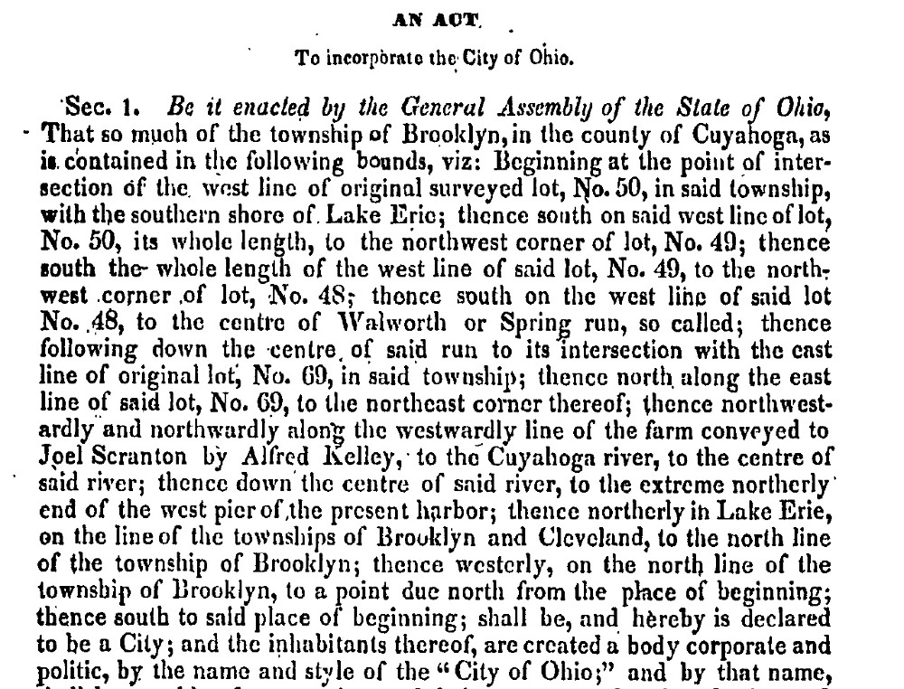
In the end, separate charters were sought for each side of the river. On March 3, 1836, Ohio City, officially known as the City of Ohio, came into existence. Notable in its charter was the new western boundary line set along the western line of original Brooklyn Township Lot No. 50, which today would be between West 58th and West 59th Streets.

Josiah Barber, who, more than anyone else, shaped the first urban community on the west bank of the Cuyahoga River, was elected the first mayor of Ohio City in 1836. He served only one one-year term and died just five years after that in 1842, more than a decade before the annexation of Ohio City to the City of Cleveland in 1854. He also didn't live to seen one last territorial change for the historic first city on the west bank. In 1853, one year before the City of Ohio was annexed to Cleveland, its voters approved an annexation proposal that, among other things, extended the western territorial limits of the city all the way to Alger (West 67th) Street. Given the efforts that Josiah Barber had made to establish this west side urban community and to then literally build a bridge between it and Cleveland on the east bank of the river, both annexations would likely have been events that he would have celebrated heartily.

Images

Charles Winslow House
Charles Winslow House In West Village, the grandest homes were located on Washington Avenue. The house in this sketch which appeared in the 1874 Cuyahoga County Atlas was built in 1836 for Charles Winslow, a Buffalo Company investor. This was the same year that West Village became part of Ohio City. After Winslow's death, it became the house of his son-in-law C. L. Russell, who led the Ohio City forces in the 1836 Battle of the Bridge. The house was razed in 1912, to make room for Bulkley Boulevard, the precursor roadway to the west Memorial Shoreway. Source: Cleveland Public Library, Digital Map Collection
Ohio City
Ohio City This mural entitled "Ohio City" was created by artist William Dolwick as part of a 1930s WPA project. Painted on an oil canvas and originally affixed to a wall at the Lorain branch of the Cleveland Public Library, the mural shows the artist's idyllic view of the status of village development on the west and east banks of the Cuyahoga River in 1834. The view is from Scranton Heights (west bank) and prominently shows Cleveland Centre (east bank) in the middle of the mural, West Village houses (west bank) to the left on the distant hilltop, and the Village of Cleveland (east bank) in the background to the right. Source: Ohio Memories
Cleveland - 1801
Cleveland - 1801 This plat map was drawn by Amos Spafford, a Connecticut Land Company surveyor, in 1801. It accurately shows that, while in this year there was village development on the east bank of the Cuyahoga River, there was none on the west bank. Source: Cuyahoga County Archives
West Village
West Village This 1833 plat map shows the proposed Buffalo Company village development, located south of the lake and river, west of the river, north of Detroit Avenue, and east of what today is West 28th Street. The development soon became known as West Cleveland village, or simply West Village. Source: Cuyahoga County Archives
Josiah Barber (1771-1842)
Josiah Barber (1771-1842) More than any other single person, Josiah Barber was responsible for the developed of an urban community on the west bank of the Cuyahoga River. He laid out the first village development south of what is today the intersection of Detroit Avenue and West 25th Street. He approved the design for Franklin Circle. He was a principal founder of St. John Episcopal Church. He donated the land for Monroe Street Cemetery as well as the land on the northwest corner of West 25th Street and Lorain Avenue which became the site of the Pearl Street Market. He proposed building the first permanent bridge across the Cuyahoga River in 1820. And he served as the first mayor of Ohio City in 1836. Source: The Western Reserve Historical Society, Cleveland, Ohio
Richard Lord (1780-1857)
Richard Lord (1780-1857) This portrait likely made from a post 1850 photograph shows Richard Lord, the youngest son of Samuel Phillips Lord, the original proprietor of nearly all of the land in Brooklyn Township. Richard Lord moved to Brooklyn Township in 1826, joining Josiah Barber as an agent for the Lord family land interests there. He had many business interests in Brooklyn Township and Ohio City, including a real estate partnership formed with Barber in 1831 and an ownership interest in the Cuyahoga Steam Furnace Company, the first manufacturing plant in the Cleveland area, formed in 1834. He also formed a partnership with fellow Ohio City Councilman William Burton, which operated a refueling station on an island in Lake Michigan for ships traveling across the Great Lakes to and from Chicago. Lord also served as a Councilman, President of Council and sixth mayor of Ohio City.
Columbus Street Bridge
Columbus Street Bridge This 1836 drawing of the first permanent bridge across the Cuyahoga River was made just a year or so after the bridge was constructed. It was a covered bridge with a draw in the middle which, when opened, allowed the masts of sailing ships to pass under it. The bridge connected Cleveland Centre to Willeyville, developments on the east and west sides of the river, which were planned and built by an investment group headed by former Cuyahoga County Sheriff, James S. Clarke. The bridge was the scene on October 31, 1836 of the locally famous Battle of the Bridge between Cleveland and Ohio City residents and officials. Source: Cleveland State University, Michael Schwartz Library, Special Collections
Cleveland and its Environs in 1835
Cleveland and its Environs in 1835 This portion of the 1835 map drawn by Cuyahoga County surveyor Ahaz Merchant shows the state of village development on both sides of the Cuyahoga River in the year before the incorporation of Ohio City and Cleveland as cities. In this year, West Village development had been extended west, as a result of the addition of the Taylor Farm allotment, from State (West 28th Street) to Harbor (West 44th) Street. Source: Cleveland State University, Michael Scwartz Library, Special Collections
Monroe Street Cemetery
Monroe Street Cemetery The land for Monroe Street Cemetery on Monroe Avenue, in Cleveland, was conveyed by Josiah Barber to William Burton, Trustee for Brooklyn Township, in January 1835, with the stipulation that it would be transferred to the new incorporated village of Brooklyn (it actually became the City of Ohio instead) to be formed later that year. The land in the township's old cemetery, located near the intersection of West 25th Street and Lorain Avenue, was needed for the burgeoning Brooklyn village development growth of the 1830s, which included Willeyville as well as Barber and Lord's newly designed village allotment. Bodies from the old cemetery were likely re-interred at Monroe Street Cemetery later that same year. This photograph of the gateway to the new cemetery was taken in 1900. Source: Cleveland State University, Michael Schwartz Library, Special Collections
Dewitt Clinton Taylor (1824-1891)
Dewitt Clinton Taylor (1824-1891) Known as Clinton Taylor, he was the son of Charles Taylor, who owned more than 100 acres of farmland, stretching (north to south) from the old river bed to where Woodbine Avenue is today, and (east to west) from West 28th Street to West 44th Street. Ezekiel Folsom purchased most of that farmland from Charles Taylor in 1835 and laid out streets and village lots that pushed the informal boundaries of both West Village and Brooklyn Village westerly. Clinton Avenue, which is part of the original Taylor Farm allotment, was named after Clinton Taylor. The above sketch was taken from his 1891 Cleveland Leader obituary. Source: Cleveland State University, Michael Scwartz Library, Special Collections
William Burton (1792-1872)
William Burton (1792-1872) A ship captain from Vermont, Burton came to Cleveland in 1835 and was the following year elected Councilman in the first Ohio City elections. No doubt this had something to do with the fact that he had formed a business partnership with Richard Lord, son of the original proprietor of Brooklyn Township. This photo was taken in Cleveland circa 1860, shortly before he retired to his island on Lake Michigan. Source: Phyllis Begens
St. John's Episcopal Church
St. John's Episcopal Church Located on Church Street, it is easily one of the City's most recognizable landmarks. It was built during the time of historic Ohio City. Construction of the church was begun in 1836 and completed in 1838. It was designed by Ohio City resident and architect, Hezekiah Eldridge. Among the founders of the parish was Josiah Barber, who, for a six year period before the church was built, allowed his house on West 25th Street to be used for church services. This photo of the church was taken in 1889. Source: Cleveland Public Library, Cleveland Illustrated (H. R. Page & Co., 1889)
Petitioning to Incorporate the Village
Petitioning to Incorporate the Village In the fall of 1835, Josiah Barber led a group of Brooklyn Township residents who petitioned the State of Ohio to incorporate their village developments on the west side of the Cuyahoga River. At some point in the legislative process, the petition was amended to seek a city charter instead. The charter creating the City of Ohio was granted by the Legislature on March 3, 1836. The above legal advertisement appeared in the November 5, 1835 edition of the Cleveland Whig. Source: Cleveland State University, Michael Schwartz Library, Special Collections
Official Boundaries in 1836
Official Boundaries in 1836 The March 3, 1836 statute which incorporated the City of Ohio clearly enumerated the boundaries of the new city. While village street and lot development had proceeded only as far west as Harbor (West 44th) Street at the time of incorporation, the territory granted to the new city extended westward all the way to the west lot line of Original Brooklyn Township Lot No. 50, today just west of West 58th Street, petitioned for by citizen group headed by Josiah Barber . Source: Cleveland State University, Cleveland Marshall College of Law Library
Last Boundary Change
Last Boundary Change In April 1853, voters of Ohio City approved an annexation proposal that added parts of of Original Brooklyn Township lots 31, 32, 33, 48, 80 and 70 to the city. With respect to the city's western limits, this annexation extended the city limits to 30 feet west of the lot line of Alger (West 67th) Street. Source: Cuyahoga County Deed Records

Location

Ohio City, Cleveland, OH

Metadata

Jim Dubelko, “Ohio City (City of Ohio),” Cleveland Historical, accessed July 27, 2024, https://clevelandhistorical.org/index.php/items/show/765.