Filed Under Transportation

Carnegie Avenue

Building the Southern Thoroughfare to University Circle

"Here in Cleveland, Euclid Avenue has been likened to New York's Broadway and Carnegie Avenue is gradually becoming our 5th Avenue. . . . It will not be long before Carnegie Avenue will be lined with many of Cleveland's largest clubs, hotels, and business concerns." — Jay B. Goodman, Treasurer of the S. H. Kleinman Realty Company (Cleveland Plain Dealer, October 31, 1926).

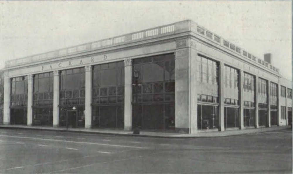
S.H. Kleinman Realty Treasurer Jay B. Goodman was not engaging in mere hyperbole when he stated that Carnegie Avenue was fast becoming Cleveland’s Fifth Avenue. In the decade of the 1920s, Carnegie Avenue was the place to be. Stretching eastward for more than three miles from East 22nd Street to Stearns Road in University Circle, it was, according to a 1928 article in the Plain Dealer, where 120 new commercial buildings had been erected in the previous four years and to where more than 129 companies had moved. Walker and Weeks, Cleveland’s premier architectural firm in the first half of the twentieth century, was one of them. In 1926, it moved its offices to a five-story building that it had designed at 2341-2351 Carnegie. In that same year, Howell and Thomas, the architects who built many glamorous Shaker Heights homes, designed and erected an office building for their firm at 3868 Carnegie. When Chicago-based Sears-Roebuck decided to expand to Cleveland in 1928, it selected a location at 8501 Carnegie Avenue for its regional offices and first store here. Dealerships for many of America’s most luxurious automobiles located on the Avenue during the decade, including Lincoln, Hudson, Pierce-Arrow, and Packard. And in 1923, the plush eight-story Bolton Square Apartment Hotel opened on the southeast corner of East 89th Street and Carnegie. And this is literally to name just a few of the many businesses that sought and found an upscale address on prestigious Carnegie Avenue in that decade.

The story of Carnegie Avenue begins in the 1890s during the City Beautiful movement. In the second half of that decade, when Chestnut Street (the original name of Chester Avenue) was first being considered as the northern thoroughfare to Cleveland’s new east side parks, planners eyed two residential streets located south of Euclid Avenue that were worthy candidates to form a future southern thoroughfare to those parks. Sibley Street had been opened between Perry (East 22nd) Street and Willson Avenue (East 55th Street) in the 1850s. East Prospect Street followed two decades later and, by 1874, stretched eastward from Willson Avenue to Bolton Avenue (East 89th Street). East Prospect’s western terminus at Willson Avenue was located only thirty feet south of Sibley’s eastern terminus, causing many Clevelanders to consider it little more than an extension of Sibley.

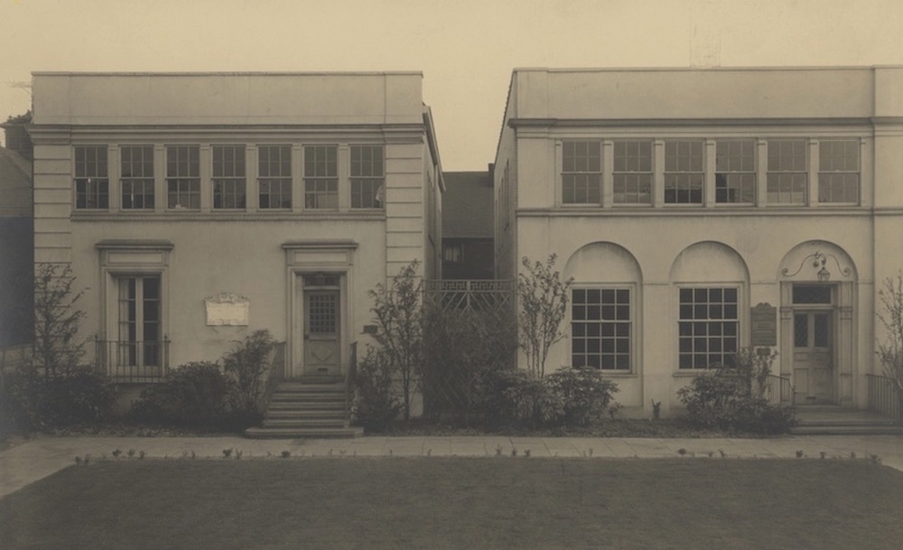
Before the two streets were reimagined by early planners as a thoroughfare, however, each was the center of a vibrant east side residential neighborhood. More than 300 single-family houses, many of Queen Anne architectural design, were located on the two streets. East Prospect Street, which was located just one block south of Euclid Avenue’s millionaire estates, was home to many prominent Clevelanders, including Lillian Towslee, one of Cleveland’s first woman physicians, who served as the second president of Women’s Hospital. From 1895 until her death in 1918, she lived in a large house at 8118 Carnegie Avenue designed by Cleveland architect Riley Austin Bissell. Three public elementary schools—Sterling, Sibley, and Bolton—were located on the streets, as were a number of other notable institutions. The Convent of the Sisters of the Good Shepherd, which ministered and provided shelter to women and girls in need, was located on the southeast corner of Sibley and Sterling (East 30th) Streets. The Gatling Gun Armory was on the north side of Sibley near Kennard (East 46th) Street. Next door to it was the Young Hebrew Men’s Association, operating in the former home of Brooks Military Academy. Maternity Hospital was located up the street in a single- family house at 134 East Prospect (6216 Carnegie). The First United Presbyterian Church (today, St. Timothy Missionary Baptist Church) sat on the northeast corner of East Prospect and Giddings Road (East 71st Street). Sibley even sported a baseball field near Kennard (East 46th) Street, called the Kennard Street Ball Park, where the Cleveland Blues of the National League played baseball from 1879 to 1884. From a late nineteenth century city planning perspective, however, what was most important about these two streets was that together they constituted almost two-thirds of the roadway needed for the proposed southern thoroughfare to the city’s east end. Newspaper accounts from that era suggest that residents of the two streets were also enthusiastic about the proposed thoroughfare, thinking that it would lead to the transformation of their streets into a leafy park boulevard with direct access to Cleveland’s new east side park system. On that score, they would soon learn that they were sadly mistaken.

It took the City of Cleveland nearly two decades to obtain voter-approved financing before it could begin acquiring land for the road extensions to create the southern thoroughfare. While the plans languished on the drawing table, several events contributed to the eventual transformation of Sibley and East Prospect Streets not into the anticipated leafy park boulevard but instead into a commercialized traffic corridor. First, in 1905, controversy erupted over what to name the new thoroughfare. When East Prospect residents learned that the City was planning to call it Sibley Avenue, they protested and petitioned the City to instead name it “Lincoln Avenue.” The City referred the matter to the Chamber of Commerce which recommended “Carnegie Avenue” as a nod to steel magnate Andrew Carnegie who earlier that year had traveled to Cleveland to testify at the criminal trial of Cassie Chadwick, a Euclid Avenue resident accused of having swindled several Cleveland banks by claiming to be Carnegie’s illegitimate daughter. Moreover, two years earlier, Carnegie had donated a large sum of money to the Cleveland Public Library to build seven new branch libraries in the City. East Prospect residents were not happy with the Chamber’s recommendation, but the City accepted it, and, in 1906, Sibley and East Prospect Streets officially became Carnegie Avenue. The second event occurred later that year when the Cleveland Board of Public Service director Daniel Leslie came out in opposition to making the two streets a park boulevard, persuasively arguing that the boulevard to the east side park system should be located closer to the Lake. And finally, within a few short years, the need to address growing traffic congestion from a proliferation of streetcars and automobiles became the City’s primary reason for building thoroughfares to and from downtown. All of the foregoing had an impact on Cleveland investors and the city’s business community. Before any road work was even started on the southern thoroughfare, commercial businesses began relocating to Carnegie Avenue in ever increasing numbers. Many were automobile-related businesses expecting to benefit from a location on the future southern thoroughfare.

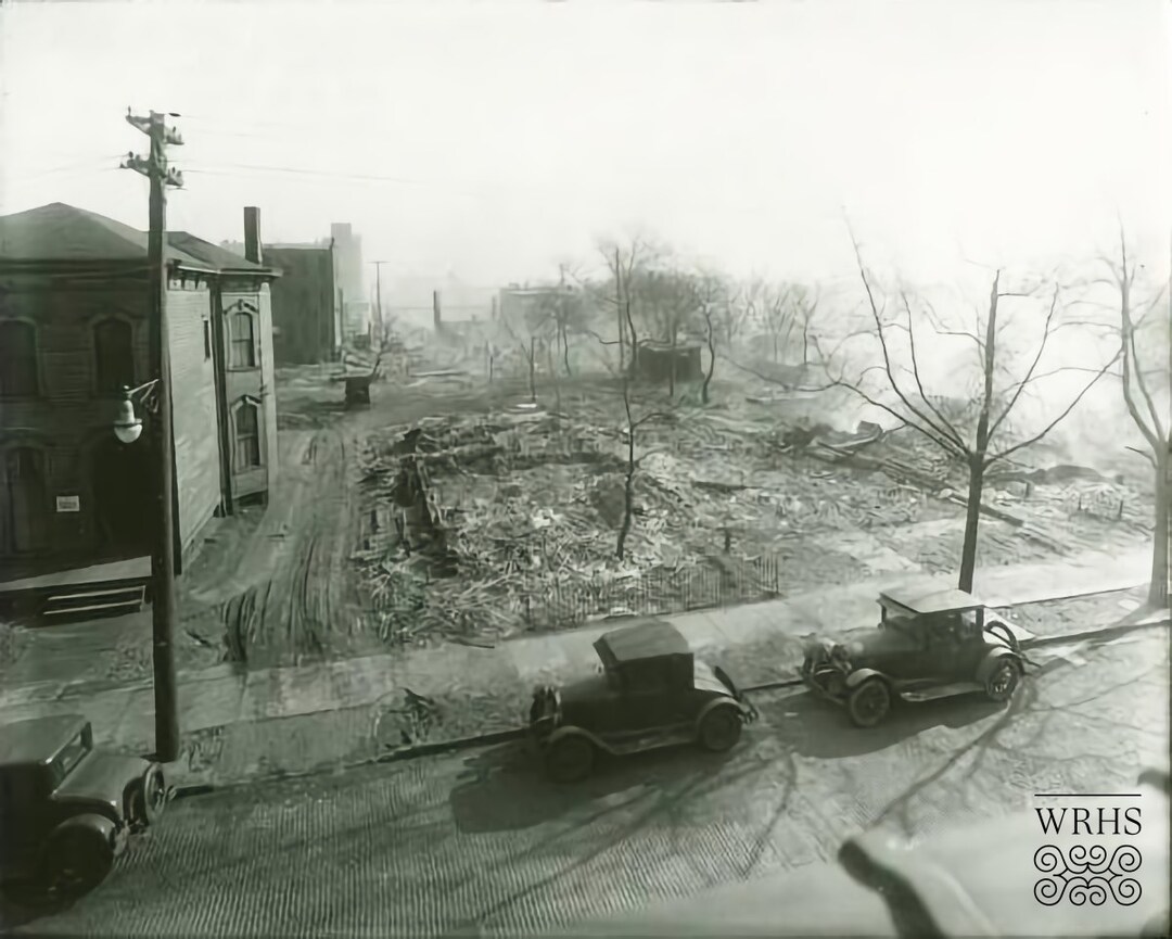
By 1917, the City’s street funding problems had been sufficiently resolved to allow it to begin acquiring land for the first extension of the southern thoroughfare--from the eastern terminus of Carnegie Avenue at East 89th Street to East 100th Street. Over the course of the next two years, land was acquired and cleared, new roadway was built and paved, and, in 1919, the extension was opened to the public. The successful construction of this first extension was not without neighborhood cost. A total of 13 single family homes on cross streets were either moved or razed in the process. In addition to those houses, Hart Hall, a four-story, eight-suite apartment building on East 93rd Street, also in the way, was moved (with its tenants still in it) to a new site on Carnegie Avenue near East 89th Street, where it later became an annex to the Bolton Square Hotel. Four years after the first extension was completed, a second from East 100th Street to East 107th Street was constructed, which removed another dozen or so houses that stood in the way. This second extension connected Carnegie Avenue to Fairchild Road, the latter road soon being renamed Carnegie Avenue from East 107th Street to Stearns Road. While Carnegie Avenue’s eastward extensions to the city’s east end were thus completed by 1923, necessary westward extensions to connect the southern thoroughfare to downtown, as well as to the west side by a proposed new high level bridge at Lorain Avenue, stalled for nearly another decade as city officials deliberated both where to locate the eastern terminus of the new bridge and how best to connect the southern thoroughfare to it. While these deliberations were continuing, the City, in 1924-1925, widened Carnegie Avenue from East 22nd to East 55th to accommodate more automobile traffic and to better align it with the roadway east of East 55th Street. In 1930, after it had determined that the location of the eastern terminus of the new bridge should be at Central Avenue near Ontario Street, the City constructed a westward extension of the southern thoroughfare from East 22nd Street in 1930-31. At East 21st Street, the extension was angled in a southwest direction in order to connect it to Central Avenue at East 14th Street. Central Avenue from East 14th Street to the new Lorain-Carnegie Bridge, which was completed and opened In 1932, was then renamed Carnegie Avenue.

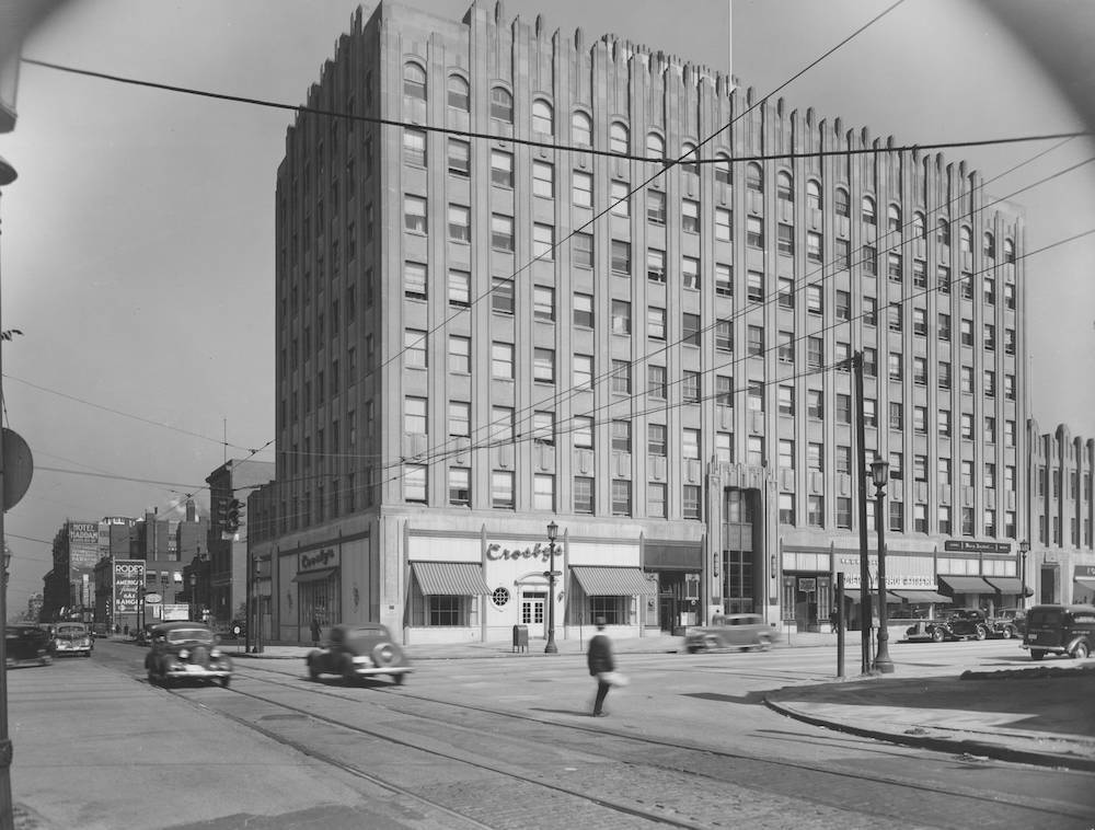
As noted above, the 1920s witnessed a dramatic transformation of Carnegie Avenue into a commercial corridor. In the next three decades, businesses continued to locate on the southern thoroughfare, further reducing the number of houses, and residents, on the Avenue. The 1930s witnessed the completion of the construction of the 12-story Gothic Revival style Cleveland Club (later the Tudor Arms Hotel) at 10600 Carnegie, as well as that of the eight-story art deco style Carnegie Medical Building at 10515 Carnegie. The 1940s saw, among other new arrivals, Central Cadillac, and the 1950s, Pratt-Webb Bakery, Reynold Machinery Co., and the General Electric X-Ray Department. The 1950s also saw the new Innerbelt Freeway cut a swath through Carnegie Avenue between East 22nd and East 28th Streets, resulting in the removal of seven houses and reducing the number of houses still standing on Carnegie Avenue to less than thirty. During these three decades, Carnegie Avenue became the busiest street in Cleveland, especially during evening rush hour, with tens of thousands of vehicles traversing it daily. It also became a motorist’s nightmare with its narrow traffic lanes, plentiful chuckholes, and distracting billboard signs. Some Clevelanders began to refer to it as “Billboard Alley,” others as “Agony Alley.” In the 1940s, Cleveland Safety Director Elliot Ness installed a new signalization system and prohibited left turns off Carnegie Avenue during rush hour, but neither solved the congestion problem. In 1953, the City began an “experiment,” making Carnegie one-way, eastbound only, during evening rush hour. The experiment worked and, for the next 50 years, motorists, during evening rush hour, could only travel east on Carnegie from Prospect Road (a diagonal roadway at East 46th Street constructed in 1931 to relieve traffic on Prospect Avenue). That half century long restriction was modified in 2003 to also permit traffic to travel westward on Carnegie during evening rush hour.

While Carnegie Avenue continued to be one of the busiest streets in Cleveland in the second half of the twentieth century, white flight and de-industrialization caused many of the commercial businesses, which had made it Cleveland's Fifth Avenue in the first half of the century, decamp to the suburbs and elsewhere, contributing to blight and urban decay on Carnegie, especially east of East 55th Street. Cleveland’s University-Euclid Urban Renewal Project No. 2 of the early 1960s targeted this area for renewal, but this designation produced no substantive changes. In the 1980s, the departure of businesses slowed, and blight and urban decay began to be addressed by joint efforts of the City of Cleveland and a number of profit and non-profit organizations, including Midtown Cleveland, Inc., which engaged in efforts to clean up Carnegie Avenue and recruit new businesses to locate on it between East 30th and East 79th Streets; the Cleveland Clinic, which dramatically increased the size of its campus lining Carnegie Avenue from East 85th Street to East 107th Street with medical buildings and parking lots; Cleveland State University which expanded its campus south to Carnegie, between East 18th and East 24th Streets; and the Gateway Sports and Entertainment Complex, which built a baseball stadium on Carnegie Avenue between Ontario and East Ninth Streets.

In 2019, the City, Midtown Cleveland, and NOACA (Northeast Ohio Areawide Coordinating Agency) produced a new Master Plan for Carnegie Avenue. Nicknamed "Reincarnegie," the Plan calls for, among other things, the construction of street and other infrastructure improvements, which would better connect Carnegie Avenue to neighborhoods to the north and south of it; new residential housing and retail stores; and other improvements that would make the southern thoroughfare a safer place for residents, pedestrians and cyclists. While it obviously comes too late for them, the early twentieth century residents of Sibley and East Prospect Streets would undoubtedly be pleased with--perhaps even enthusiastic about--the new plan.


Images

Upper Carnegie Avenue in 1930.
Upper Carnegie Avenue in 1930. The view is looking west from East 90th Street. In the foreground on the left you can catch a glimpse of Bolton Public School, erected in the late 1800s. The eight-story building on the right is the Bolton Square Hotel, built in 1923. Next to it is Hart Hall moved from East 93rd Street to this location in 1919. Each of these buildings, as well as every other building visible in this photograph, is gone, almost all of them replaced by buildings, parking lots or green space on the Cleveland Clinic campus. Source: Cleveland Public Library, Photograph Collection
Centennial Bicycle Parade on East Prospect Street.
Centennial Bicycle Parade on East Prospect Street. Employees of the White Sewing Machine Co.'s bicycle club head west on East Prospect (Carnegie Avenue), between Bolton Avenue (East 89th Street) and Willson Avenue (East 55th Street), during the City's Centennial Bicycle Parade held on July27, 1896. The Club won an award for "best appearance" in the parade that celebrated Cleveland's 100th anniversary.. In 1896, this part of what is today Carnegie Avenue was the center of a thriving upper class residential neighborhood . Source: Cleveland Public Library, Photograph Collection
Early Commercialization of Carnegie Avenue
Early Commercialization of Carnegie Avenue In 1903, just several years after it was announced that Cleveland planned to use Sibley Street as part of its proposed new southern thoroughfare to the city's east end, the Cleveland Laundry Company moved from a building located on Water (West 9th) Street to a new building at 170 Sibley Street (2840 Carnegie Avenue). The company was one of a number of laundries, bakeries, and automobile businesses, which located on the future Carnegie Avenue in the first decade of the twentieth century. This sketch of the Cleveland Laundry Company's new building appeared in the Cleveland Plain Dealer on August 23, 1902. Source: Cleveland Public Library, Newspaper Collection
The Verne
The Verne Not only commercial businesses located in the early twentieth century upon what would soon become Carnegie Avenue. A number of apartment buildings went up on both Sibley and East Prospect Streets in this period, some of them obviously designed for Cleveland's elite. The Verne, designed by architect Gustave B. Bohm and erected on the northeast corner of East Prospect (Carnegie) Avenue and East Madision (East 79th) Street in 1903, was one of them. An advertisement that appeared in the Cleveland Plain Dealer on November 2, 1902, stated that each of the 12 suites in the building would have "a large private hall, and ample closet room, large window seats in the dining room finished in quartered white oak, and side boards and refrigerators built in. The parlors will be finished in birch, the halls will have marble wainscotting and mosaic floors, and the suites will have handsome mantels. The bedrooms are to be in white enamel. The bathrooms will have tiled wainscotting and floors, plumbing of most modern design. There will be no inside suites, each room having outside light, and all suites will have rear balconies and stairways." The apartment building is no longer standing. It appears to have been razed or otherwise destroyed in the late 1960s or early 1970s. Source: Cleveland Public Library, Photograph Collection
St. Luke's Hospital
St. Luke's Hospital In 1908, St. Luke's Hospital moved from its original location on Woodland Avenue to this new building at 6606 Carnegie Avenue designed by architect Frederic William Striebinger. When the hospital moved to a new and larger facility on Shaker Boulevard in 1927, the building on Carnegie Avenue became home to Polyclinic Hospital for the next 50 years. Today, it is the home of Cityview Healthcare and Rehabilitation Center. Source: Cleveland State University, Michael Schwartz Library, Special Collections
How Carnegie Avenue got its Name
How Carnegie Avenue got its Name In 1905, the City of Cleveland proposed to rename East Prospect "Sibley Avenue." When residents on East Prospect complained that they did not want that name, the City asked the Cleveland Chamber of Commerce to pick a compromise name. The Chamber settled on "Carnegie Avenue" as a nod to industrialist Andrew Carnegie who had come to Cleveland that year to testify against Cassie Chadwick, a wealthy woman who had swindled several Cleveland banks. The above sketch from the Chadwick trial appeared in the Cleveland Leader on March 7, 1905. Source: Cleveland Public Library, Newspaper Collection
Two of the Nineteenth Century Homes Lost
Two of the Nineteenth Century Homes Lost In the course of extending Carnegie Avenue eastward from East 89th Street to East 100th Street during the period 1917-1919, thirteen single family houses were either razed or moved. The two houses shown in this 1911 photograph once sat at 2079 and 2083 on East 90th Street. According to local architectural historian Craig Bobby, the house at 2083 East 90th (right) was a "sophisticatedly designed Queen Ann era house, moderately expensive to build." The house at 2079 East 90th (left), he added, was the older of the two, likely built around 1870. In the background on East 93rd Street is Hart Hall, which was not razed as these two houses likely were, but moved. Source: Cleveland Public Library, Digital Photograph Collection
Moving Hart Hall
Moving Hart Hall The first extension of Carnegie Avenue--eastward from East 89th Street to East 100th Street--was begun in 1917. Standing in the path of the planned extension was Hart Hall, a four story, eight suite apartment building designed in 1903 by architects Searles & Hirsh and erected at 2080 East 93rd Street. In April, 1919, the building was slowly moved--fifty feet each day--from its original location to 8919 Carnegie Avenue, where, in 1923, it became an annex of the new Bolton Square Hotel built in that latter year. Hart Hall was demolished in circa 1967 by the Cleveland Clinic. This 1919 photograph shows the apartment building up on blocks and workers of G. Alexander and Sons posed ready to begin moving it. Source: Cleveland Public Library, Photograph Collection
The Walker and Weeks Building
The Walker and Weeks Building When it was built in 1926 at 2341-2351 Carnegie Avenue, it was originally called the Jones-Finny Lincoln Building after the automobile dealership which occupied the entire first floor of the building. In the 1920s, as realtors and other city boosters touted the benefits of locating on Cleveland's "5th Avenue," a number of automobile dealerships--including ones for Pierce-Arrow, Hudson, and Packard, in addition to Lincoln, responded by moving onto the Avenue in that decade. The building today is better known as the Walker and Weeks building after the famed Cleveland architects who not only designed it but moved their offices to the building. This photograph was taken in 1937 after the Lincoln automobile dealership had left and had been replaced, in 1935, by the R. J. Schmunk Hudson automobile dealership. The building is still standing today and is part of the Walker and Weeks Apartment complex located near the Cleveland State University campus. Source: Cleveland State University, Michael Schwartz Library, Special Collections
Howell and Thomas Buildings
Howell and Thomas Buildings In 1926, the architectural firm of Howell and Thomas, which had designed many of the most glamorous houses in tony Shaker Heights, designed and built these two very similar two-story with basement office buildings at 3866 and 3868 Carnegie Avenue. Howell and Thomas occupied one of the buildings while the other was leased to the landscape architectural firm of Pitkin and Motts. Both of the buildings are still standing on Carnegie Avenue today. Source: Cleveland Public Library, Photograph Collection
The first Sears, Roebuck Store
The first Sears, Roebuck Store In 1927, when Chicago-based Sears, Roebuck and Company decided to expand and build retail stores in Cleveland, it picked Carnegie Avenue as the location for its main store. The Sears store opened at 8501 Carnegie Avenue on August 4, 1928. (A branch store was opened that same year on Lorain Avenue near West 117th Street.) The Carnegie Avenue store closed in 1980 and the building later became part of the Cleveland Play House complex. The complex was purchased by the Cleveland Clinic in 2009. The old Sears store, as of 2020, is still standing. This photograph of the store was taken in 1941. Source: Cleveland Public Library, Photograph Collection
The Packard Dealership Building
The Packard Dealership Building In 1928, the Packard Motor Car Co., a luxury automobile manufacturer, opened a large complex on Carnegie Avenue, between East 93rd and East 96th Streets, including this two-story building on the southeast corner of Carnegie and East 93rd. The frontage shown here on Carnegie Avenue was a display room for new Packard automobiles. The two-story building, which was designed by architect Albert Kahn of Detroit, still stands today and is part of Cleveland Clinic's campus. This photograph appeared in an advertisement in the 1929 Cleveland City Directory. Source: Cleveland Public Library, Street Directory Collection
Carnegie Medical Building
Carnegie Medical Building While the 1920s were the heyday of commercial construction on Carnegie Avenue, commercial buildings continued to be erected on Carnegie Avenue for the next three decades. In 1931, this beautiful eight-story art deco medical office building was erected at 10515 Carnegie Avenue. It later became the home of the Ohio College of Podiatric Medicine. In 2009, the building was razed by Cleveland Clinic. This photograph of the building, which also shows the popular Crosby's Restaurant on the ground floor, was taken in 1940. Source: Cleveland Public Library, Photograph Collection
Extending Westward
Extending Westward Stalled for nearly a decade, the long awaited extension of Carnegie Avenue westward from East 22nd Street was finally begun in 1930. This photograph, which appears to have been taken from the second floor of a building on the east side of East 22nd Street, presents a view west and shows a number of sites where buildings had been either razed or moved to make room for construction of the extension. Source: Western Reserve Historical Society
The Lorain-Carnegie Bridge
The Lorain-Carnegie Bridge This bridge over the Cuyahoga River, which is known today as the Hope Memorial Bridge and which was completed in 1932, connected Lorain Avenue on the west side to the newly completed Carnegie Avenue on the east side, thereby providing west siders with access to the southern thoroughfare and the east end of Cleveland. This photo was taken in 1931. Source: Cleveland Public Library, Photograph Collection
The Diagonal Road
The Diagonal Road As early as 1927, plans were submitted to the City Plan Commission for the construction of a diagonal road from Prospect Avenue to Carnegie Avenue between East 40th and East 55th Streets. The purpose of the road was to relieve congestion on Prospect, but also to provide customers with better access to merchants with shops on Prospect. The road, now known as Prospect Road, was finally built in 1931. It extends diagonally from midway between East 40th and East 46th on Prospect Avenue to midway between East 47th and East 55th on Carnegie Avenue. This photo of traffic at the intersection of Prospect Street and Carnegie Avenue was taken in 1936. Source: Cleveland State University, Michael Schwartz Library, Special Collections
A House victimized by Retail Expansion
A House victimized by Retail Expansion This Victorian era house, which stood at 6917 Carnegie Avenue, was designed by Architect Sidney Badgley and built in 1895 for Rev. J. W. Malone, an Evangelical Quaker minister who founded the Cleveland Friends Bible Institute. After Malone and his family moved from the house in 1918, a commercial store was added onto the front and it became a pet shop and dog hospital operated by Considine & Powell. Later, the house and store front were torn down to make room for a larger and more modern commercial building on the property. This photograph was taken in 1944. Architect Badgley designed several other buildings on Carnegie Avenue including St. Timothy's Baptist Church on the northeast corner of East 71st and Carnegie. Source: Cleveland State University, Michael Schwartz Library, Special Collecctions
Central Cadillac
Central Cadillac While this automobile dealership was a late arrival among the dealerships which once dotted Carnegie Avenue from East 22nd to East 89th Streets, it is the only new car dealership that has survived on the Avenue to this day. Central Cadillac, which opened for business in 1943 on East 71st street, moved to a new "state of the art" dealership building at 2801 Carnegie Avenue on April 29, 1949. Source: Cleveland Public Library, Digital Newspaper Collection
A view of Traffic from Bolton Square Hotel
A view of Traffic from Bolton Square Hotel On December 17, 1953, the City of Cleveland began an "experiment" with one-way traffic on Carnegie Avenue during evening rush hour from 4:00-6:30 PM. The "experiment" would last for 50 years, ending in 2003. This photograph, dated December 17, 1953 shows traffic heading east on Carnegie near East 89th Street, presumably after 6:30 PM. Note the five houses and apartment buildings on the south side of the street. All are now gone, largely replaced by a Cleveland Clinic parking lot that stretches from East 89th Street almost all the way to East 86th Street. Source: Cleveland State University, Michael Schwartz Library, Special Collections
The Impact of the Cleveland Clinic
The Impact of the Cleveland Clinic This 1972 sketch superimposed upon an aerial view of Carnegie Avenue graphically shows how Cleveland Clinic has changed Carnegie Avenue over the years. The sketch was for the proposed new 22-story Park Plaza Hotel and several additional buildings that were built along Carnegie Avenue, between East 90th and East 100th streets in 1974. The Park Plaza Hotel, which later became the Omni International Hotel and which faced Carnegie Avenue, was razed in 2000, after the Clinic in 1999 opened the new Intercontinental Suites Hotel fronting on Euclid Avenue at East 93rd Street. Today, Cleveland Clinic buildings and parking lots line the entire north side, and most of the south side, of Carnegie Avenue East 86th Street all the way to East 107th Street, covering approximately one-fourth of the length of Carnegie Avenue from the Hope Memorial Bridge to Stearns Road. Source: Cleveland State University, Michael Schwartz Library, Special Collections
Starlight Boyd's House.
Starlight Boyd's House. One of the first African Americans to own a home on then prestigious Carnegie Avenue was Albert Duncan "Starlight" Boyd, a Mississippi native who moved to Cleveland in the late nineteenth century, became a successful businessman and political activist here, and, in 1917, bought a nineteenth century Queen Anne style house at 7410 Carnegie in which he lived for the rest of his life. While white families fled to the suburbs in the 1950s, Boyd's daughter, Gloria Boyd Clark, who inherited the house, stayed and maintained it in such good condition that, in 1984, she was given an award and recognition by MidTown Corridor, Inc. (now, Midtown Cleveland, Inc.), the economic development corporation which for almost forty years has been trying to breathe new life into Cleveland's Midtown Corridor. After Clark's death in 2005, the house along with the one next door at 7414 Carnegie, which her family also owned, were torn down and a large billboard sign (still standing in 2020) was put up on the properties by Clear Channel Outdoor, Inc. This photo, which shows Clark sitting in front of her two Carnegie Avenue houses, appeared in the Cleveland Plain Dealer on November 10, 1984. Source: Cleveland Public Library, Digital Newspaper Collection
Lancer Steak House
Lancer Steak House In the post World War II era, a number of African-American-owned businesses opened on Carnegie. Perhaps none was as well-known as Lancer Steak House at 7707 Carnegie Avenue. The popular restaurant, which soon also became a favored meeting place for Cleveland politicians, was opened in 1961 by Fleet and Beulah Slaughter, who operated it until Fleet's death in 1975. The restaurant changed hands several times before it was purchased by George Dixon in 1986. Dixon is shown in this 1995 photo standing in front of the restaurant. The restaurant continued to be a popular spot on the Avenue until 2009 when it suffered a disastrous fire and was forced to permanently close. Source: Cleveland.com

Location

Cleveland, OH

Metadata

Jim Dubelko, “Carnegie Avenue,” Cleveland Historical, accessed July 4, 2024, https://clevelandhistorical.org/items/show/914.