Franklin Circle

The Centerpiece of Josiah Barber's Radial Street Plan

Franklin Circle, the centerpiece of one of Cleveland's rare radial street designs, was surveyed in 1836--the same year in which Ohio City became a city and Cleveland's chief commercial competitor across the Cuyahoga River. The land for the Circle, which lies at what is today the intersection of West 28th Street, Fulton Road, and Franklin Boulevard, was donated to Ohio City by Josiah Barber, a Connecticut pioneer who came to the Western Reserve in 1818 and settled the area just west of the Cuyahoga River and just south of the Lake. Today this area lies at the heart of the Ohio City neighborhood.

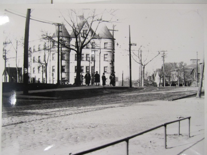
As originally laid out, the Circle was called Franklin Place or Franklin Square, and was informally utilized for several decades as an open farmers market. Later, after Ohio City was annexed to the City of Cleveland, Cleveland moved that "west side" market in 1859 to the northwest corner of Pearl (West 25th) Street and Lorain Avenue, and eventually in 1912 to the northeast corner of that same intersection where it has been known ever since as the West Side Market. The City then built on the Circle the west side's first public park, which featured a water fountain surrounded by an iron fence. In 1872, Franklin Boulevard was extended through the park as part of a renovation by the City of Cleveland. At about this time, the park was remodeled with a rock garden and, for years thereafter, was known as Modoc Park. In 1907, a combination of streetcar tracks and newly constructed apartment buildings contributed to almost destroy the park-like setting of the Circle, which thereafter became known simply as Franklin Circle.

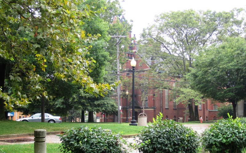
From the mid-nineteenth century until the early twentieth century, Franklin Circle was surrounded by some of the grandest mansions on the west side of Cleveland, including those of Marcus Hanna, Daniel Pomeroy Rhodes, James Ford Rhodes, and Robert Russell Rhodes. Today, the Circle is still a pleasant area of the near west side with a park-like ambiance. However, most of the great mansions of the Circle are long gone. They have been replaced by multifamily and institutional buildings, including Lutheran Hospital and the Masonic Temple, which in the early twentieth century joined Franklin Circle Christian Church as the predominant buildings on the Circle.

Images

Franklin Circle - circa 1920
Franklin Circle - circa 1920 This undated photo was taken on the north side of Franklin Circle facing south. In the background partially hidden by trees is Franklin Circle Christian Church. Street car tracks are visible on the road around the Circle as well as along Franklin Avenue bisecting the Circle. Originally known as Franklin Place or Franklin Square, the Circle was created in 1836 and initially served the neighborhood as the site of an open farmers market. Image courtesy of Raymond L. Pianka Collection
A Birds Eye View
A Birds Eye View This part of artist A. Ruger's "Birds Eye View of Cleveland Ohio - 1877" shows with amazing detail the street plan and housing of the Franklin Circle neighborhood in 1877. The church with the tall spire--numbered by the artist with the numeral "46" and seen on the southwest side of the Circle, is Franklin Circle Christian Church. The large man-made structure on the right side of the drawing several blocks west of the Circle (and numbered "107") is the Kentucky Street Reservoir, a critical component of Cleveland's early waterworks system. Image courtesy of the Library of Congress Collection
A Circle for the Wealthy
A Circle for the Wealthy This map which appeared in a 1975 Cleveland Press article shows the footprints and owners' names of the mansions and estates which surrounded Franklin Circle in the late nineteenth and early twentieth centuries. On the southeast side of the Circle are the mansions of Daniel P. Rhodes and his son-in-law Marcus Hanna. On the north side is the mansion of Daniel's son and famed historian, James Ford Rhodes. On the southwest side of the Circle is the mansion of Daniel Rhode's other son and notable businessman and philanthropist, Russell R. Rhodes. Other mansions and their owners are noted as well. Image courtesy of Cleveland State University Library, Press Collection
Modoc Park
Modoc Park Before it was known as Franklin Circle, the circular shaped one and one-half acres of greenery near the intersections of Franklin Avenue, Fulton Road, and Hanover Street (now West 28th Street) was known to west side residents as Modoc Park. The park was constructed in 1872 by the City of Cleveland. It acquired its unusual name because of controversy surrounding the replacement of an ornamental fountain on the site with a rockery. The rockery can be seen being attended to by a caretaker in this 1888 photo of the park. Image courtesy of Cleveland State University Library, Press Collection.
Street car tracks through the Circle
Street car tracks through the Circle This undated photo taken in the early twentieth century shows the streetcar tracks on Franklin Avenue near the Circle. The tracks were installed in the years 1907-1908 and destroyed the nature-like setting of Modoc Park. After the tracks were constructed through the Park, the park area became known simply as Franklin Circle. The building in the background with the turreted towers is the Beckwith Apartment building. Built in 1899, it stood on the Circle until it was razed at some time after 1981. Source: Cleveland Public Library, Photograph Collection
A West Side Promenade Walk
A West Side Promenade Walk Wealthy Franklin Circle and Franklin Avenue neighborhood residents conduct a promenade walk on the Kentucky Street Reservoir in this c. 1870 painting. The Reservoir, which no longer exists, was located several blocks west of Franklin Circle on the south side of Franklin Avenue between Kentucky (W. 38th) Street and Duane (W. 32nd) Street. The church seen on the right side of the painting is the Franklin Avenue Methodist Episcopal Church, built in 1870. It, like the Reservoir, no longer exists. Creator: Cleveland State University, Press Collection, and Encyclopedia of Cleveland History
The Lesser Millionaires Row
The Lesser Millionaires Row This 1912 photograph shows the residential splendor of Franklin Boulevard west of Franklin Circle in the early twentieth century. The photo was taken on the north side of the street at approximately 4012 Franklin, facing west. In this era, Franklin Boulevard--then called Franklin Avenue--was home to one of the most exclusive neighborhoods of Cleveland--perhaps second only to Euclid's Millionaires Row. While both Franklin Circle and Franklin Boulevard have changed over the century that followed, this type of winter scene is still all too familiar to Cleveland residents Source: Cleveland Public Library, Photograph Collection
Franklin Circle Today
Franklin Circle Today This photograph taken on the north side of Franklin Circle facing south shows that the Circle still retains a park-like atmosphere. Seen in the background of this photo is Franklin Circle Christian Church, which has maintained a presence on the Circle since 1848. Image courtesy of Jim Dubelko
Aerial View of Franklin Circle
Aerial View of Franklin Circle This recent Google map satellite photo shows that over the course of the last 175 years, Franklin Circle has become something less than a circle. Institutional and multifamily residential buildings have intruded on several quadrants of the Circle, and the pattern of the roads as originally designed to radiate from the Circle has also significantly been altered. Image courtesy of Google Maps.

Location

Franklin Circle, Cleveland, OH

Metadata

Jim Dubelko, “Franklin Circle,” Cleveland Historical, accessed July 27, 2024, https://clevelandhistorical.org/items/show/535.