<?xml version="1.0" encoding="UTF-8"?>
<feed xmlns="http://www.w3.org/2005/Atom">
  <title type="text">Cleveland Historical</title>
  <updated>2026-08-21T21:27:40+00:00</updated>
  <generator uri="http://framework.zend.com" version="1.12.20">Zend_Feed_Writer</generator>
  <link rel="alternate" type="text/html" href="https://clevelandhistorical.org/"/>
  <link rel="self" type="application/atom+xml" href="https://clevelandhistorical.org/items/browse?output=rss2"/>
  <id>https://clevelandhistorical.org/</id>
  <author>
    <name>Cleveland Historical</name>
    <uri>https://clevelandhistorical.org</uri>
  </author>
  <link rel="hub" href="http://pubsubhubbub.appspot.com/"/>
  <entry>
    <title type="html"><![CDATA[Cleveland Lakefront Reservation: The Long Struggle to Maintain the City&#039;s Lakefront Parks]]></title>
    <summary type="html"><![CDATA[<img src="https://clevelandhistorical.org/files/fullsize/679dd9b50e9291e954a7c85e132098bd.jpg" alt="Edgewater Beach and Skyline" /><br/><p>Since 2013 Cleveland’s lakefront parks have been run by the Cleveland Metroparks. Before the Metroparks assumed administration of the parks, the state of Ohio operated them as units of the Cleveland Lakefront State Park, and before that the city of Cleveland’s Board of Park Commissioners controlled these parks. It was a long road of pollution and vandalism that led to Metroparks control over the lakefront parks. Each previous administration started out with a good budget and short-term plans for the lakefront parks, but long-term maintenance issues ultimately undermined each administration’s stewardship of the parks. </p><p>The urban park movement came rather late to Cleveland, emerging in September 1865 when a city council committee was appointed to consider the establishment of public parks. Finally, after new state laws were enacted, in 1871 Cleveland’s Board of Park Commissioners was created. In 1874 the park board began selling park bonds to finance land acquisition and improvements to create several parks, including Lake View Park. This park stood on the natural bluff overlooking the Lake Erie until Municipal Stadium (later replaced by today’s FirstEnergy Stadium)—built on fill that extended the lakeshore northward—blocked the view. Cleveland’s parks started to take shape over the next ten years through various donations, but they lacked in comparison to park development in other cities with populations similar to Cleveland’s, and with growing urbanization it seemed that the city was running out of land to set aside for parks. Various state legislation led to an increase in park power, and by 1900 Cleveland would gain ten new parks totaling over 1,200 acres, approximately two thirds of which had been donated. Finally a good amount of Cleveland’s lakefront had been saved for parks and conservation in <a href="https://clevelandhistorical.org/items/show/121">Edgewater Park</a>, <a href="https://clevelandhistorical.org/items/show/143">Gordon Park</a>, and <a href="https://clevelandhistorical.org/items/show/996">Lake View Park</a>.</p><p>With so much newly acquired land, the park system started to struggle with the biggest problem that would plague the lakefront. Even the bonds the park commissioners sold could only be used to purchase new lands, not maintain them. Through the first twenty years of the 1900s, multiple public works projects were completed to appease the residents who claimed the city only opened parks away from the urban center. Cleveland’s combined storm water sewage system was also being completed at this time and the water treatment plants sat basically at the edge of Edgewater Park and Gordon Park. On most days the water treatment plant could do its job but with heavy rain, Cleveland’s sewers combined storm water and sewage, dumping the sludge into Lake Erie. </p><p>As in other cities, Cleveland’s parks would serve as a major focus for WPA workers during the Great Depression, but as people left for World War II, vandalism struck the lakefront parks. Continually the parks’ budget got smaller and smaller, not to mention that the Memorial Shoreway sliced through most of the lakefront parks by the 1950s. A series of Cuyahoga River fires culminated in national attention to Cleveland’s growing water pollution problem by 1969. Although the federal government passed the Clean Water Act of 1972, leading to gradual improvements in water quality, little progress was made in curbing the pollution problem in the lakefront parks. No longer able to keep up its coveted park system Cleveland was once so proud of, the city signed a long-term lease with the Ohio Department of Natural Resources, making Edgewater, Gordon, and Wildwood Parks part of a new Cleveland Lakefront State Park.</p><p>The new state park lasted until 2013. The state put together a 100-year plan for the state of the Lakefront Park in 1984, implementing facilities for fishing, boating, swimming, and picnicking and day-use facilities at all designated park areas, but it was only loosely followed over the ensuing years. The main area of attention was cleaning the polluted waters and lakefront which had become a virtual dumping ground. The lakefront continued to change when newly elected mayor Michael White proposed several different projects two years before Cleveland’s bicentennial in 1996. The plan, dubbed North Coast Harbor, included a new science center, an aquarium, and many improvements to the port included a new Regional Transit Authority (RTA) waterfront rapid line. The plan, totaling more than $285 million, promised to make the Cleveland Lakefront State Park Ohio’s most visited state park.</p><p>Although the plan was only partially realized, the lakefront still saw heavy use and, unfortunately, slipping maintenance. As one city council member described in 2004, the parks had become overgrown, the beaches littered with debris, and public bathrooms in deplorable shape. The state simply did not have the funding after cuts, and residents started discussing giving control to the Cleveland Metroparks. Over the next decade it became clearer through the continued pollution that a change was direly needed. After the Clevleand Metroparks assumed stewardship of the parks from the state in 2013, the city gave the Metroparks $15 million for cleanup and upgrades. The Cleveland City Planning Commission, along with the Cleveland Metroparks, put out a waterfront district plan in 2014 to decide the future of the area. The best fit for the lakefront parks seems to be control by a dedicated parks organization committed to long-term conservation. Cleveland Metroparks has answered the call.</p><p><em><strong><a href="https://clevelandhistorical.org/items/show/796">For more (including 9 images) view the original article</a></strong></em></p>]]></summary>
    <published>2017-05-13T21:56:04+00:00</published>
    <updated>2026-04-17T19:17:41+00:00</updated>
    <link rel="alternate" type="text/html" href="https://clevelandhistorical.org/items/show/796"/>
    <id>https://clevelandhistorical.org/items/show/796</id>
    <author>
      <name>Connor Kenney</name>
    </author>
  </entry>
  <entry>
    <title type="html"><![CDATA[Pioneering Aviation at Euclid Beach: Glenn Curtiss&#039;s Epic Flight Over Lake Erie]]></title>
    <summary type="html"><![CDATA[<img src="https://clevelandhistorical.org/files/fullsize/e3add3734398d1eee6b9666849c64dfe.jpg" alt="Curtiss Prepares for Takeoff" /><br/><p>Tens of thousands of people lining the shore of Lake Erie to watch a plane go by. While the idea seems ludicrous today, this is exactly what happened on August 31, 1910, when pioneering aviator Glenn Curtiss took off from Euclid Beach Park and headed west towards Cedar Point amusement park in Sandusky, Ohio. His 60-mile trip took him one hour and eighteen minutes to complete, and set a world record for distance flown over water. </p><p>A crowd of 18,000 flocked to Euclid Beach to see his plane take off, and all across Cleveland, people left their workplaces and headed outdoors to catch a glimpse of the 'birdman.' The scene was repeated the following day when Curtiss made his successful return trip from Cedar Point to Euclid Beach. For his efforts, Curtiss won a $5,000 prize, as well as the adoration of an entire city. Speaking at Euclid Beach before his flight, Curtiss looked towards the future, stating, "Within two years I expect to see aeroplanes which will carry at least ten passengers, being used as a means of transportation." Indeed, following his success in Cleveland, Curtiss continued to be a pioneer in the field of aviation, founding the Curtiss Aeroplane and Motor Company (now part of the Curtiss-Wright Corporation) and working with the United States military to develop planes for use in battle.</p><p>Meanwhile, Cleveland's fascination with airplanes would continue in the years following Curtiss's flight. In 1911, 30,000 Clevelanders converged on Euclid Beach to watch another aviation pioneer, Harry Atwood, land his biplane during a twelve-day trip from St. Louis to New York that set a new distance record. Cleveland soon became a key locale in the aviation industry. In 1918, the city landed a spot on the first government airmail route. That same year, Glenn L. Martin opened a factory on St. Clair Avenue that produced the Martin MB bomber for the military. A number of companies that produced airplane parts sprung up in Cleveland in the 1920s and 1930s, as well. And the spectacle of Curtiss's flight would be reproduced on a much larger scale beginning in 1929, when Cleveland played host to the National Air Races for the first of many times.  </p><p><em><strong><a href="https://clevelandhistorical.org/items/show/560">For more (including 8 images&#32;&amp;&#32;1 audio file) view the original article</a></strong></em></p>]]></summary>
    <published>2012-09-25T16:43:14+00:00</published>
    <updated>2026-04-17T19:17:39+00:00</updated>
    <link rel="alternate" type="text/html" href="https://clevelandhistorical.org/items/show/560"/>
    <id>https://clevelandhistorical.org/items/show/560</id>
    <author>
      <name>Michael Rotman</name>
    </author>
  </entry>
  <entry>
    <title type="html"><![CDATA[White City Park: Entertainment, Amusement, and Leisure on the Lake Erie Shore]]></title>
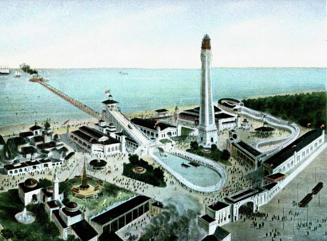
    <summary type="html"><![CDATA[<p><strong><em>White City was noted for its amusements, attractions, and recreational activities as businessmen and politicians commanded its fate for more than a century in a growing and prospering city.</em></strong></p><img src="https://clevelandhistorical.org/files/fullsize/9b21074194c03a9d4834bf53f1d1400f.jpg" alt="Aerial View of White City" /><br/><p>During the 1970s the area that now occupies the western edge of Cleveland’s Easterly Wastewater Treatment Plant was still known as White City Park. The tract of land bordered by Bratenahl Village to the west and the city sewer authority property to the east existed as a public park in various incarnations since 1900. Lake Shore Boulevard bounded its entrance to the south at East 140th Street in Collinwood Village (later annexed by Cleveland). The park's lakeshore was attractive to swimmers, fishermen, and boaters for the rest of the 20th century.  White City Park has shared several names and faces over the past century.</p><p>The 1.5-mile lakefront area to the east of Bratenahl Village was originally known as Manhattan Beach and is still informally named that today. The “White City” space noted above was first cited in the Cleveland Plain Dealer in June 1900 as Manhattan Beach Park in announcements of fraternal organization and secret society gatherings. The park also hosted baseball, bowling, a dance hall, entertainment, and a bathing beach. Its entertainment value to the Collinwood Village neighborhood was evident with the newspaper announcements and stories of daily activities and events at the park from 1900 to 1904. One socio-political dispute played out in the park and among its nearby neighbors. The Beal Law provided local options concerning alcohol sales and consumption. The dispute between the ‘wets’ and the ‘drys’ in the Collinwood community carried on for years. Undercover detectives were dispatched to the area in and around Manhattan Beach Park to ensnare alcohol salesmen for the Collinwood Mayor’s court. Repeated polling switched the wet-dry rules three times between 1902 and 1908 prior to Collinwood’s annexation into Cleveland in 1910, but stories abounded about the behavior in the neighborhood. Edward C. Boyce purchased Manhattan Beach Park early in 1905 with the intent to further develop it into an amusement park. </p><p>In the golden era of Cleveland’s amusement parks, White City Amusement Park was one of many built to compete with the most successful of them all, Euclid Beach Park, about a mile east on the lake, and was even served by the same streetcars. The two parks became common destinations for a day’s outing for the few seasons that White City Park and Euclid Beach Park were neighbors. White City Park shared a common design with the famous New York-based Coney Island. Ed Boyce, an owner of Coney Island’s Dreamland Park, adopted its concepts to build White City Park. The general idea was to bring in attractions, entertainers, and celebrities to draw people to the park. The Park was built in eleven weeks and featured a boardwalk, Shoot the Chutes, the Bostock Animal Show, Bump-the-Bumps, a scenic railway, and a midway which featured Drs. Couney and Stewart’s infant incubator hospital. About 20 premature babies, referred by Cleveland area physicians, were under care and on display as the best and most promising hope for infant survival. The first ‘resident’ arrived in June 1905 in time for the Park’s opening. The hospital gained local notoriety with full capacity and subsequent reunion celebrations in years to come.</p><p>Cleveland, however, suffered from a lack of star power and the Dreamland concept was less than successful. Unlike Euclid Beach, White City Park charged an admission fee, which hurt its business. After a fire burned down over half of the park in 1906 and a windstorm caused severe damage in 1907, the owners had been through enough. White City Park was closed in 1908 after only four years in operation. In 1909, new owners reopened it as Cleveland Beach Park to host local gatherings, much like Manhattan Beach Park did earlier in the decade. Between 1909 and 1911, investors and managers combined to rename attractions at White City. The Cleveland Trust Co. foreclosed on the property, a sheriff’s sale ensued, and M. F. Bramley bought White City land and Luna Park with the intention to manage several amusement parks in the region. He remodeled the property once more as Bay Park [Amusement Co.] in 1911, just barely long enough to be noted on some local maps. The company ceased operations within two months, spelling the end of amusement park activity.</p><p>The next several years saw White City revert to ‘city park’ mode with accommodations for picnic and game grounds and beach access. Much of the news concerning the area was devoted to the development of the adjacent sewage treatment plant serving Cleveland’s east side. Later in the decade, the grounds were devoted to stables and drill and practice by National Guard troops training for threatening World War I border duty. </p><p>Through the ensuing decades, the city of Cleveland maintained the park for swimming, fishing, and boating under the auspices of the White City Yacht Club and the Northeast Yacht Club despite occasionally dangerous water quality conditions created by the neighboring sewage treatment facility’s deficiencies. The constants which remain today through the evolving story of Collinwood’s northwestern shore, then and 100 years hence, are White City Park and the Manhattan Beach neighborhood.</p><p><em><strong><a href="https://clevelandhistorical.org/items/show/262">For more (including 15 images) view the original article</a></strong></em></p>]]></summary>
    <published>2011-07-17T16:14:48+00:00</published>
    <updated>2026-04-17T19:17:38+00:00</updated>
    <link rel="alternate" type="text/html" href="https://clevelandhistorical.org/items/show/262"/>
    <id>https://clevelandhistorical.org/items/show/262</id>
    <author>
      <name>Jim Lanese</name>
    </author>
  </entry>
  <entry>
    <title type="html"><![CDATA[Huntington Reservation: A Hobby Farm Turned Public Beach]]></title>
    <summary type="html"><![CDATA[<img src="https://clevelandhistorical.org/files/fullsize/af3c8185bbfe7dea5512b21e86f51779.jpg" alt="Beach Postcard" /><br/><p>Today, the Huntington Reservation is known mostly for its beach, leaving visitors unaware of the rich history of the land beneath their sand filled shoes.  However, it is possible for one to stand on the Lake Erie shore and imagine Native Americans holding powwows inside mammoth sycamore trees, or bison strolling along the Indian path that would later become Lake Road.  Or perhaps one can imagine standing in the orchards and vineyards of Bay Village's earliest pioneers, or hearing the echoes of industrialist John Huntington's steam engine pumping water from Lake Erie to irrigate his hobby farm and bring drinking water into his stately summer home. </p><p>This 100-acre chunk of Lake Erie shoreline in Bay Village truly has a deep and influential history that extends far back beyond its purchase by the Cleveland Metroparks in 1925 for $500,000. For thousands of years prior to European arrival in the New World, it was part of an attractive hunting ground for Native Americans. The area became largely empty in the century prior to the Revolutionary War, however, after inter-tribal wars over control of the lucrative trade in beaver pelts forced many natives to leave. Claiming the area south of Lake Erie through creative cartography, Connecticut surveyors, most famously Moses Cleaveland, began parceling land along the south shore of Lake Erie in 1796. The land that became Bay Village was surveyed and laid out in 1806, by which point all Indian claims in the area had been extinguished. Two land speculators soon purchased the empty township and named it after their home town of Dover, Connecticut. The Lake Erie microclimate provided excellent growing conditions for orchards and vineyards for early settlers once the land near the shore was cleared of massive 17-foot circumference sycamore trees. Pioneers began settling and farming fruit in Dover Township around 1810.  </p><p>In 1880, the most desirable 100 acres of the Dover Township shoreline became a summer retreat and hobby farm for John Huntington (1832-1893), a wealthy Cleveland industrialist with ties to John Rockefeller's Standard Oil Company.  In addition to building a fine house on the land, Huntington, an inventor and avid tinkerer, constructed a water tower and maintained a steam pump system to irrigate his orchards and gardens.  He built several other structures on his property, a few of which remain standing today.  </p><p>The Cleveland Metroparks purchased Huntington's estate in 1925, allowing the public to visit and contemplate the past historical eras in which this spot of lakeshore once played a part, or to just enjoy a cool Lake Erie breeze on a hot summer day.</p><p><em><strong><a href="https://clevelandhistorical.org/items/show/244">For more (including 7 images&#32;&amp;&#32;4 audio files) view the original article</a></strong></em></p>]]></summary>
    <published>2011-07-11T09:17:17+00:00</published>
    <updated>2026-04-17T19:17:37+00:00</updated>
    <link rel="alternate" type="text/html" href="https://clevelandhistorical.org/items/show/244"/>
    <id>https://clevelandhistorical.org/items/show/244</id>
    <author>
      <name>Rob Grossman</name>
    </author>
  </entry>
  <entry>
    <title type="html"><![CDATA[Gordon Park]]></title>
    <summary type="html"><![CDATA[<img src="https://clevelandhistorical.org/files/fullsize/cmp-gordonparkca1900_562c0bc300.jpg" alt="Gordon Park, Circa 1900" /><br/><p>When William J. Gordon died in 1892, he donated the land that became known as Gordon Park to the City of Cleveland under the condition that it would forever remain a free, public park.  By the time of his death, Gordon, who made his fortune in the wholesale grocery and iron ore businesses, had accumulated some 122 acres of land along the shoreline near the spot where the Doan Brook enters Lake Erie.  Gordon Park opened to the public in 1893 and quickly became a recreational destination for Clevelanders living on the east side.  A grand bathhouse catered to the multitudes who crowded onto the park's beach, and the city also provided facilities for boaters, fishermen, and picnickers.  Meanwhile, further inland, south of the beach, wooded areas and formal gardens provided quiet retreats for those seeking a more relaxed atmosphere.    </p><p>In the decades after World War II, however, Gordon Park began to decline. Water pollution affected all of the city's lakefront parks and Gordon Park was no exception. Swimming in particular became increasingly unsafe. Moreover, the late-1960s construction of a straighter route for I-90 (an upgrade of the Memorial Shoreway that the Works Progress Administration had built from East 9th Street to Gordon Park in the late 1930s) literally split the park in two, separating its lakefront areas from those further inland.  Meanwhile, Doan Brook was culverted, and the area directly to the east of the park (Dike 14) became a dredge disposal site.  </p><p>Lake Erie may not have gone anywhere, but it is hard to imagine that William J. Gordon would recognize his 122-acre gift to Cleveland if he could see it today. </p><p><em><strong><a href="https://clevelandhistorical.org/items/show/143">For more (including 9 images&#32;&amp;&#32;1 audio file) view the original article</a></strong></em></p>]]></summary>
    <published>2011-02-07T11:18:04+00:00</published>
    <updated>2026-04-17T19:17:37+00:00</updated>
    <link rel="alternate" type="text/html" href="https://clevelandhistorical.org/items/show/143"/>
    <id>https://clevelandhistorical.org/items/show/143</id>
    <author>
      <name>Michael Rotman</name>
    </author>
  </entry>
  <entry>
    <title type="html"><![CDATA[Edgewater Park]]></title>
    <summary type="html"><![CDATA[<img src="https://clevelandhistorical.org/files/fullsize/edgewaterpark-clevelandstateuniveristy-clevelandmemory_cut5471-terminaltower_edgewaterparkview-nd_b305fc8132.jpg" alt="View of Downtown Cleveland from Edgewater Park" /><br/><p>Edgewater Park makes up the western-most grounds of the Cleveland Lakefront State Park.  Running between the Memorial Shoreway and Lake Erie just to the west of downtown Cleveland, the park encompasses over 130 acres of land and overlooks 6,000 feet of shoreline.  The park is divided into upper and lower levels, which are connected by a paved pathway.</p><p>The grounds for Edgewater Park were purchased by the City of Cleveland in 1894 and have provided popular recreational spaces for Cleveland residents since its opening the following year. Since the second half of the 20th century, however, Cleveland's park department was faced with juggling depleting resources and the problems of general upkeep, pollution, and security for the public grounds. Unable to maintain its park lands, the City of Cleveland leased Edgewater Park to the Ohio Department of Natural Resources for fifty years in 1978.  While maintaining its identity as Edgewater Park, the park is now joined along with five other public spaces to make up the Cleveland Lakefront State Park. </p><p><em><strong><a href="https://clevelandhistorical.org/items/show/121">For more (including 7 images&#32;&amp;&#32;1 audio file) view the original article</a></strong></em></p>]]></summary>
    <published>2011-01-05T22:05:46+00:00</published>
    <updated>2026-04-17T19:17:37+00:00</updated>
    <link rel="alternate" type="text/html" href="https://clevelandhistorical.org/items/show/121"/>
    <id>https://clevelandhistorical.org/items/show/121</id>
    <author>
      <name>Richard Raponi</name>
    </author>
  </entry>
</feed>
