<?xml version="1.0" encoding="UTF-8"?>
<feed xmlns="http://www.w3.org/2005/Atom">
  <title type="text">Cleveland Historical</title>
  <updated>2026-08-22T03:16:29+00:00</updated>
  <generator uri="http://framework.zend.com" version="1.12.20">Zend_Feed_Writer</generator>
  <link rel="alternate" type="text/html" href="https://clevelandhistorical.org/"/>
  <link rel="self" type="application/atom+xml" href="https://clevelandhistorical.org/items/browse?output=rss2"/>
  <id>https://clevelandhistorical.org/</id>
  <author>
    <name>Cleveland Historical</name>
    <uri>https://clevelandhistorical.org</uri>
  </author>
  <link rel="hub" href="http://pubsubhubbub.appspot.com/"/>
  <entry>
    <title type="html"><![CDATA[Landmark Office Towers: The Professional and Corporate Heart of the Terminal Group]]></title>
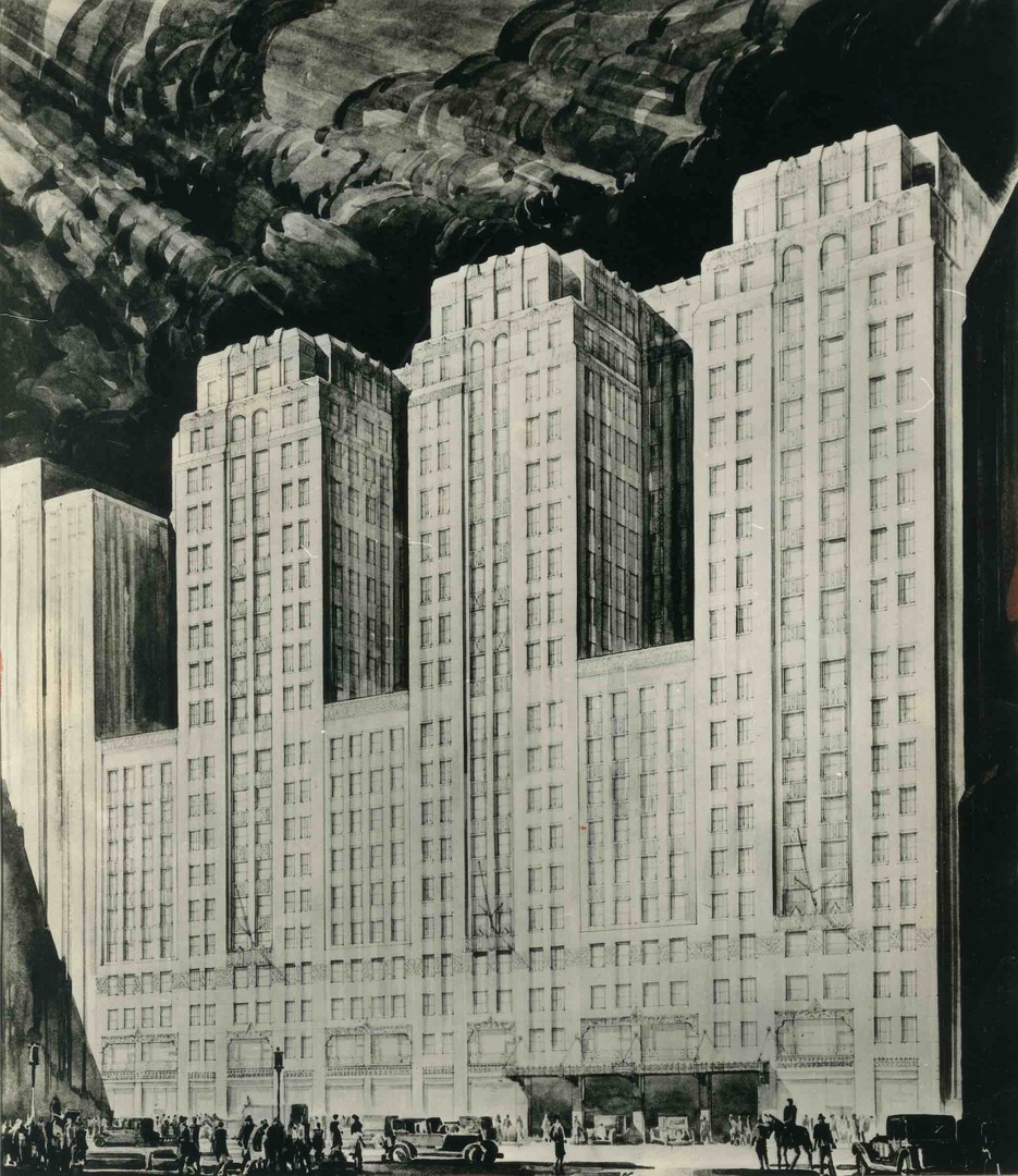
    <summary type="html"><![CDATA[<p><strong><em>Tower City Center, with its Public Square entrance, iconic tower, and flanking hotel and casino, has long overshadowed the office buildings to its rear despite their shared lineage as heirs of the Van Sweringen brothers’ vision. Yet the Landmark Office Towers complex on West Prospect Avenue deserves more attention for its splendid architectural details, novel interior features, and place in the history of some of Cleveland’s most significant corporate giants. </em></strong></p><img src="https://clevelandhistorical.org/files/fullsize/cf17bb9783a0e01e8bcbc10cdc20b577.jpg" alt="Original Rendering of Builders Exchange Building" /><br/><p>The three adjoining buildings that comprise Landmark Office Towers were originally conceived as part of Oris P. and Mantis J. Van Sweringen’s Cleveland Union Terminal complex, the “city within a city” the brothers launched in the 1920s. Designed by Graham, Anderson, Probst & White of Chicago and built between 1929 and 1930, the buildings occupied an entire city block bounded by Prospect Avenue, Huron Road, Ontario Street, and West 2nd Street, all of which were built as viaducts above the railroad tracks entering the Union Terminal. </p><p>In keeping with the idea of a city within a city, each building focused on a different sector: the Medical Arts Building was built for physicians’ and dentists’ offices; the Builders Exchange Building was devoted to businesses associated with the building trades; and the Midland Bank Building was dedicated to banking institutions and other business firms. The buildings included passageways connecting them with each other and with other components of the Terminal complex. A skybridge over Prospect, planned to link the Medical Arts Building with Higbee’s department store, was never added. </p><p>The three buildings were all built with structural steel frames clad with gray limestone on the lower four floors, cream face brick above, and terra-cotta trim near the tops. Detailed Art Deco motifs graced each facade, and the complex featured setbacks and light wells to break their bulk and provide ventilation. Inside, they featured travertine marble floors, fluted pilasters, plaster ceilings with ornamental friezes, and bronze elevator doors. The three-story lobby of the Midland Bank Building featured a wood-burning fireplace, a mezzanine, and pillars and panels carved from the trunks of seven giant oak trees. The trees were selected from an English estate and transported by steamship from Liverpool. The Builders Exchange Building included Guildhall, a tenth-floor restaurant inspired by a 15th-century London namesake, and a two-story demonstration house called the <a href="https://clevelandhistorical.org/admin/items/show/1028">Home in the Sky</a> on its two top levels.</p><p>The introduction of such an expansive block of choice office space soon after the onset of the Great Depression had a profound impact on downtown, precipitating a consolidation of business and professional activity around the Terminal and leaving older office buildings with hard-to-fill vacancies. Four major corporate headquarters relocated to the complex between 1930 and 1935. Two were local: Sherwin-Williams moved its offices from its Canal Road property into portions of the Midland Building and Builders Exchange Building, while Standard Oil Co. of Ohio (Sohio) left the East Ohio Gas Building on East 6th for the Midland Building. The Midland Building also attracted the Erie Railroad headquarters away from New York City in 1931 and Republic Steel from Youngstown in 1935. The arrival of the latter led the Medical Arts Building to be renamed the Republic Building. </p><p>Yet the Depression also forced the complex to grapple with challenges. In 1932, Midland Bank went bankrupt and merged into Cleveland Trust, closing its offices in its namesake building. Three years later, the Van Sweringen Company went bankrupt. Thereafter, ownership of the towers complex was administered by the Prospect Terminals Building Co., a subsidiary of Cleveland Terminal Building Co. In 1940, the Cleveland Builders Exchange left for a new headquarters on Euclid Avenue, and Sherwin-Williams expanded to the floors that had housed the Exchange's Home in the Sky. At that time, the building was named the Guildhall Building.</p><p>In 1950, Cleveland Terminal Building Co. sold the entirety of the Union Terminal group except the rail station in 1950 to the 66 Trust of Philadelphia. That same year, the four main tenants of the towers complex — Republic Steel, Erie Railroad, Sohio, and Sherwin-Williams — formed RESS Realty (a portmanteau of their names) to coordinate leasing of office space in the three conjoined towers. For the 35 years that followed, the complex harbored a workforce of around 5,000 people. </p><p>In 1986, ten years after the Erie-Lackawanna Railroad (formerly Erie Railroad) closed its Cleveland headquarters following its merger into Philadelphia-based Conrail, Sohio completed its move from the Midland Building to its new 45-story headquarters on Public Square. Following the departures of these firms and Republic’s recent merger into LTV Steel, RESS Realty was administered by only LTV and Sherwin-Williams. In the year preceding Sohio’s exit, RESS Realty renovated and rebranded the LTV-Guildhall-Midland Building complex as Landmark Office Towers. </p><p>During the renovations, Sherwin-Williams bought the complex, bringing its ownership back to Cleveland. Changes included a central lobby for the elevator banks serving all three buildings, along with the revitalization of the Midland Building’s lobby, which Sohio had modernized into offices with dropped ceilings in 1970, as the Van Sweringen Arcade. The bank’s vault became Haymarket Restaurant, later Piperade, and then Hyde Park Chophouse until the space closed in 2011. </p><p>The renovation and promotion succeeded in turning around the towers at a critical time. After Sohio moved out, the complex’s occupancy dropped from 100% to 62%, but upon completion of the renovations, it bounced back to 90%. Landmark Office Towers had a nearly four-decade run until its owner, Sherwin-Williams, sold the complex to Detroit-based Bedrock in 2023 ahead of the paint and coatings company’s move to its new 36-story headquarters tower on Public Square. Today, the future of the complex seems tied to Bedrock’s Riverfront Cleveland project, but its precise use is uncertain. Office demand in downtown districts has not recovered from the pandemic collapse of 2020, and conversion of such a massive structure to residential use is costly. But the towers — with their Art Deco flourishes, contribution to a big-city atmosphere, and central location in an evolving downtown — deserve a new, bold vision.</p><p><em><strong><a href="https://clevelandhistorical.org/items/show/1084">For more (including 21 images) view the original article</a></strong></em></p>]]></summary>
    <published>2026-04-03T13:57:15+00:00</published>
    <updated>2026-07-29T17:40:46+00:00</updated>
    <link rel="alternate" type="text/html" href="https://clevelandhistorical.org/items/show/1084"/>
    <id>https://clevelandhistorical.org/items/show/1084</id>
    <author>
      <name>J. Mark Souther</name>
    </author>
  </entry>
  <entry>
    <title type="html"><![CDATA[Clark Field]]></title>
    <summary type="html"><![CDATA[<img src="https://clevelandhistorical.org/files/fullsize/447580b69c6c476372cb9f4a38a13663.jpg" alt="Clark Field, 1970" /><br/><p>Like so many parts of the city and the nation, Clark Field was once a farm—a swampy but arable plot stretching from Auburn Avenue to the Cuyahoga River. In the late 1940s, the city of Cleveland bought 67 acres of the farm to use as a recreation area for area residents. For the next three years, the city filled in the swampy areas. On immediately adjoining land, the federal government continued to maintain garages stocked with army surplus material. These 17 acres were later added to the park and the garages were removed. </p><p>In 1951 the City of Cleveland allocated $75,000 for a Clark Field play area, a football field and two baseball diamonds. Later, a stadium was built with concession stands and restrooms. For several decades, Lincoln High School and Cleveland Central Catholic High School played football games on Friday nights and often practiced there during the week. Tennis courts were built and children were enrolled in city-sponsored tennis leagues and tournaments. Every child in the program received a free tennis racket and lessons.</p><p>Over the years, the field deteriorated and the stadium was demolished. Concurrent with the depopulation of Tremont, park use plummeted. Baseball teams still played there (Little League, men’s leagues, a Republic Steel team), but the park’s principal features became discarded tires, empty beer bottles, drug paraphernalia and danger. Large gaps appeared in the tennis courts. Clark Field became a dumping ground and the place to go to burn a car.</p><p>In 2001, area residents banded together to take the park back. Friends of Clark Field was formed in 2002—in collaboration with the Mentor-Castle-Clark block club, Kent State Urban School of Design, and the City of Cleveland’s Parks and Recreation Department and Research, Planning and Development Departments. The new organization developed a master plan focused on cleaning up the park, bringing back recreation activities and maximizing safety. More than 100 trees were planted, a basketball court was added, and waste receptacles, picnic tables and benches made from recyclable materials were installed. Friends of Clark Field also worked to bring the first dog park to the city. </p><p>From 2012 to 2014, friends of Clark Field held regular free events for children and families. Funded by grants, Clark Field hosted Friday night movies, Easter egg hunts, Halloween parties, arts and crafts days, and family nights with ice cream, snow cones, popcorn, balloons, face painting, free books, pizza, apples and entertainment. Flag football teams began using Clark Field. High school baseball and men’s and women’s softball teams played weekly games. High school football practices returned. Flower and tree planting continued, along with regular maintenance and cleanup days. Under the aegis of the Cleveland Metroparks, plans were laid for a Towpath Trail Extension, which will ring the western and northern borders of Clark Field,  running from the northern entrance of Steelyard Commons to Literary Avenue. </p><p>In 2015, the City of Cleveland stopped issuing permits for events and sports at Clark Field so soil testing could be undertaken in preparation for additional park upgrades. Unfortunately, EPA tests revealed that several areas required soil reclamation—a slow and costly process. Consequently, the flow of traffic and events slowed significantly. Tests continue as of this writing. However, members of Friends of Clark Field are confident that—once remediation efforts are completed, the master plan fully implemented, and the Towpath Trail completed—Clark Field will reclaim and most likely exceed the significant progress achieved in the previous one and a half decades. </p><p><em><strong><a href="https://clevelandhistorical.org/items/show/771">For more (including 3 images) view the original article</a></strong></em></p>]]></summary>
    <published>2016-10-20T14:32:31+00:00</published>
    <updated>2026-04-17T19:17:41+00:00</updated>
    <link rel="alternate" type="text/html" href="https://clevelandhistorical.org/items/show/771"/>
    <id>https://clevelandhistorical.org/items/show/771</id>
    <author>
      <name>Beverly Wurm</name>
    </author>
  </entry>
  <entry>
    <title type="html"><![CDATA[Kingsbury Run]]></title>
    <summary type="html"><![CDATA[<img src="https://clevelandhistorical.org/files/fullsize/896546489e8c64a172ad2a2fa4d1faef.jpg" alt="From a Shanty Town to a Landfill" /><br/><p>Kingsbury Run refers to an area along the east side of Cleveland near Shaker Heights that stretched westward through Kinsman Avenue and down to the Cuyahoga River.  It also included a natural watershed that runs through East 79th Street in Cleveland where natural creeks drain storm water into the Cuyahoga River from areas that are now known as Warrensville Heights and Maple Heights. The name Kingsbury Run comes from James Kingsbury, the first inhabitant of Newburgh (1797) and one of the earliest settlers of the Western Reserve area. In the late 1800s, the city commissioned a new sewer tunnel system project.  This was constructed to pass through the Kingsbury Run area under Kinsman Avenue. </p><p>The Kingsbury Run stretch of land separated Cleveland from Newburgh and became an area for railroad traffic. Industry boomed in this area, including the crude oil refinery belonging to John D, Rockefeller and the oil and naphtha works of William Halsey Doan. The boom years, however, were followed by a wave of poverty. During the Great Depression, the industry began to collapse and Cleveland's workforce suffered. Minorities and immigrants were among the hardest hit. The groups that were affected the worst included African Americans, particularly those from the Cedar-Central area; a Hungarian community in Kinsman to the east of Cedar-Central; Czech and Slovak neighborhoods east of downtown along the lakefront; and Polish, Czech and Irish neighborhoods along the banks of the Cuyahoga River. Many of these displaced and out of work people took up residence in abandoned plots of land and formed communities of their own that became known as shantytowns. One of these types of settlement formed in Kingsbury Run. </p><p>The impoverished population of the area continued to grow into the late 1930s. A large wave of new residents moved in from other lakefront shantytowns as these were being removed by the city. It was during this time that Kingsbury Run grew to notoriety by being thrust into the spotlight as a crime scene. Many of the victims of the still unidentified Kingsbury Run Butcher were discovered in the shantytown. Hinting at the gruesome nature of the killings, the case soon became known as the Cleveland Torso Murders.  </p><p>Beginning with the discovery of the first victim in September of 1934 thirteen people were brutally murdered over the course of four years. All of them were decapitated, some while they were still alive. The first victim was a woman determined to be in her mid-30s was never identified and was referred to as “The Lady of the Lake.” Though this killing was not first attributed to the serial killer at the time, it would be considered as the killer's first victim later in the investigation. In 1936 the recently appointed Cleveland Safety Director Eliot Ness was placed on the case.</p><p>In 1938, Cleveland safety director Eliot Ness ordered and conducted a raid of the area that resulted in the eviction of 300 squatters as well as the burning of at least 100 shanty homes.  The murders continued until the last victim was discovered in August 1938, after which the murders simply ceased. The Torso Murders case remains unsolved. Two decades later, the city set out to redevelop Kingsbury Run into a low-income housing area as part of the Garden Valley federal urban renewal project. Constructed on a slag dump donated by Republic Steel, Garden Valley was emblematic of a national tendency in the 1950s to relegate renewal housing to marginal inner-city lands. </p><p>Kingsbury Run is still remembered today, mostly for a violent period of time in Cleveland history. When city government makes reference to this area, it is mostly to note the vast sewer system that runs through it.</p><p><em><strong><a href="https://clevelandhistorical.org/items/show/376">For more (including 5 images) view the original article</a></strong></em></p>]]></summary>
    <published>2011-12-21T21:23:48+00:00</published>
    <updated>2026-04-17T19:17:38+00:00</updated>
    <link rel="alternate" type="text/html" href="https://clevelandhistorical.org/items/show/376"/>
    <id>https://clevelandhistorical.org/items/show/376</id>
    <author>
      <name>Alea Lytle</name>
    </author>
  </entry>
  <entry>
    <title type="html"><![CDATA[Cuyahoga River Fire: The Blaze That Started a National Discussion]]></title>
    <summary type="html"><![CDATA[<img src="https://clevelandhistorical.org/files/fullsize/riverfire-press-oilslick65_a14ac5ba8c.jpg" alt="Oil Slick, 1965" /><br/><p>The story of the Cuyahoga River fire of 1969 - the event that sparked pop songs, lit the imagination of an entire nation, and badly tarnished a city's reputation - is built more on myths than reality. Yes, an oil slick on the Cuyahoga River - polluted from decades of industrial waste - caught fire on a Sunday morning in June 1969 near the Republic Steel mill, causing about $100,000 worth of damage to two railroad bridges. Initially the fire drew little attention, either locally or nationally. The '69 fire was not even the first time that the river burned. Dating back to the beginning of the twentieth century, the river had caught fire on several other occasions.</p><p>The picture of the Cuyahoga River on fire that ended up in Time Magazine a month later - a truly arresting image showing flames leaping up from the water, completely engulfing a ship - was actually from a much more serious fire in November 1952. No picture of the '69 river fire is known to exist. </p><p>Throughout much of Cleveland's history, water pollution did not trouble the city's residents very much. Instead, water pollution was viewed as a necessary consequence of the industry that had brought prosperity to the city. This attitude began to change in the 1960s as ideas associated with what would become known as environmentalism took shape. In 1968, Cleveland residents overwhelmingly passed a $100 million bond initiative to fund the Cuyahoga's cleanup. Also, by this time deindustrialization was somewhat alleviating the pollution problem, as factories closed or cut back operations. Ironically, the city and its residents were beginning to take responsibility for the cleanliness of the river in the years before the infamous fire of 1969.</p><p>The '69 fire, then, was not really the terrifying climax of decades of pollution, but rather the last gasp of an industrial river whose role was beginning to change. Nevertheless, Cleveland became a symbol of environmental degradation. The Time article contributed to this, as did the notoriety of Cleveland Mayor Carl Stokes. Stokes, who was the first black mayor of a major city when elected in 1967, became deeply involved with the issue, holding a press conference at the site of the fire the following day and testifying before Congress - including his brother US Representative Louis Stokes - to urge greater federal involvement in pollution control. The Stokes brothers' advocacy played a part in the passage of the federal Clean Water Act of 1972. In Cleveland, a number of Cleveland State University students celebrated the inaugural Earth Day in 1970 by marching from campus to the river to protest pollution.  </p><p>Even though it has been misunderstood, the 1969 Cuyahoga River fire did help bring about positive change. The river's water quality improved during the following decades, and business investors capitalized on this by converting parts of the Flats' abandoned industrial landscape into an entertainment district featuring restaurants, nightclubs, and music venues.  </p><p>Much of the industry that both made Cleveland rich and caused its river to burn may never be coming back, but Clevelanders are meeting this challenge by reshaping their city to reflect its current realities.</p><p><em><strong><a href="https://clevelandhistorical.org/items/show/63">For more (including 8 images&#32;&amp;&#32;2 videos) view the original article</a></strong></em></p>]]></summary>
    <published>2010-09-22T13:36:07+00:00</published>
    <updated>2026-04-17T19:17:37+00:00</updated>
    <link rel="alternate" type="text/html" href="https://clevelandhistorical.org/items/show/63"/>
    <id>https://clevelandhistorical.org/items/show/63</id>
    <author>
      <name>Michael Rotman</name>
    </author>
  </entry>
</feed>
