<?xml version="1.0" encoding="UTF-8"?>
<feed xmlns="http://www.w3.org/2005/Atom">
  <title type="text">Cleveland Historical</title>
  <updated>2026-05-02T04:41:47+00:00</updated>
  <generator uri="http://framework.zend.com" version="1.12.20">Zend_Feed_Writer</generator>
  <link rel="alternate" type="text/html" href="https://clevelandhistorical.org/"/>
  <link rel="self" type="application/atom+xml" href="https://clevelandhistorical.org/items/browse?output=rss2"/>
  <id>https://clevelandhistorical.org/</id>
  <author>
    <name>Cleveland Historical</name>
    <uri>https://clevelandhistorical.org</uri>
  </author>
  <link rel="hub" href="http://pubsubhubbub.appspot.com/"/>
  <entry>
    <title type="html"><![CDATA[Geauga County Courthouse: From Log Cabin to Landmark on the Chardon Square]]></title>
    <summary type="html"><![CDATA[<p><strong><em>Resilience, perseverance, and dedication to history drive Chardon residents to continue improving their beloved courthouse, which has served as the seat of governance for Geauga County since 1805.</em></strong></p><img src="https://clevelandhistorical.org/files/fullsize/9ad50285c8e25a45f5fa52bd2fdf78b4.jpg" alt="The Fourth Geauga County Courthouse" /><br/><p>Chardon’s early planning began with Peter Chardon Brooks, a wealthy Boston merchant who acquired land from the Connecticut Land Company in 1798. He offered the land to settlers with the only stipulation being to name it Chardon. The commissioners accepted this proposal in 1808. Before Chardon could be settled, one matter of prerequisite importance had to be addressed – the establishment of a permanent seat of justice for the Geauga County. The commissioners of the county's Common Pleas Court then assigned Samuel W. Phelps to purchase and lay out land for this purpose. Reflecting New England ideals of structure and order, in 1808, the first building to be erected in Chardon was a courthouse.  </p><p>Reflecting the realities of frontier life, however, this first “courthouse” was little more than a repurposed log cabin, originally built by Abraham Skinner for Captain Edward Paine Jr. and his family. The one-room building was primitive, with a single door and window, a basic fireplace and chimney, and wide, rough boards for flooring. It also served as a temporary jail. It had a large, split log that functioned as a seat for the judges and a single large table providing a desk for the lawyers.  Realizing that the log cabin had served its temporary functions, the time came for a larger courthouse. </p><p>In 1813, Samuel King was contracted to build the second courthouse where the fire station currently stands on the square. It was built of rugged timber and had two floors. The first floor housed one cell as a temporary jail, and the second floor was the courtroom. The courthouse had multiple additional functions as Chardon was being built up. It also served as a meeting hall for political, religious, and social gatherings, as well as providing a school room for the few children who lived in Chardon. </p><p>By 1824, village leaders realized that Chardon needed better quarters for the county offices. The county allotted funds to build the southern half of the third courthouse, which also served as a jail. It was not until 1829 that the northern half of the courthouse was completed. Built of bricks in Greek Revival style, this two-story building featured large columns on the front portico. Its increased architectural sophistication mirrored the growing wealth of the county and its businesses. Unfortunately, this courthouse was not to last. </p><p>On July 25, 1868, the <em>Cleveland Plain Dealer </em>reported terrible news: “the whole business portion of Chardon, including the courthouse and jail, were burned last night.” The damage was not only material, estimated at the then-enormous sum of $100,000, but also functional; the loss of the official county buildings cast uncertainty of Chardon’s future as the county seat.  </p><p>After the fire, Chardon's citizens refused to give up. The county quickly issued a contract to Messrs, Herrick & Simmonds of Cleveland to rebuild the business district and courthouse. A newspaper article from December 4, 1868, reported on the rebuilding of Chardon: “When the improvements are completed, Chardon will become one of the handsomest villages in the State.” Another newspaper article from January 29, 1869, raved about “Chardon rising from her ashes. A disaster transformed into a blessing.” By this time, six months after the disaster, Chardon had already established a building committee, secured funding, and had built Union Block (now Main Street) on the former ruins, as well as the Randall Block (now South Hambden Street), a new section that expanded the business district around the square. The highlight of rebuilding was the courthouse, now located at the head of the public square. </p><p>
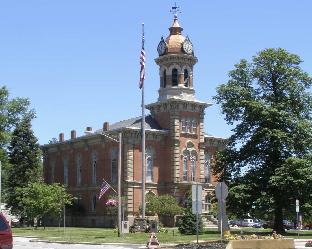
Unlike its predecessors, the architecturally picturesque fourth Geauga County Courthouse, with its octagonal steeple and interestingly designed windows, endures. Faced with brick and stone trim, the North Italianate building cost $88,862. The courthouse and the two blocks of storefronts to its west form a historic district listed on the National Register of Historic Places. The square tower, detailed cupulas, and dome give this building its distinctive look. The dome roof with clock faces on four sides and its weathervane are the crowning features. Chardon had built a courthouse to match the prestige of the town and its importance in Geauga County.     </p><p>In 2020, city officials began to discuss the need to expand the courthouse. The county's judiciary had outgrown the building, which needed not only structural renovations but also technological upgrades, especially to security features. More than a century and a quarter after the current courthouse was built, Chardon residents remained protective of their historic buildings. Originally, when it was proposed for the courthouse to get an addition, residents and the Chardon Square Association sent letters opposing the expansion. County Commissioner Janet Novak acknowledged that the community had “strong feelings” about historic Chardon Square and that “any change to the square was a sensitive subject.” These concerns delayed the expansion project for years. </p><p>In 2023, city officials and Chardon residents finally reached an agreement on the expansion. As the project neared completion in 2025, Commissioner James Dvorak, a retired Chardon bricklayer and stonemason, applauded city leaders’ willingness to prioritize the historic preservation of a building whose “Italianate arches and towers have defined Chardon Square for more than 150 years,” which meant that the addition to the courthouse had to blend with the existing structure. Dvorak noted that. the county returned to the same Cleveland-area quarry used in the 19th century to source Berea sandstone to ensure that the expansion matched the original. The latest addition to the Geauga County courthouse shows how much history means to the residents of Chardon. </p><p>As Chardon grows, residents still treasure its historical atmosphere. A newspaper article from 1902 boasted of “Chardon, typical New England village. Ideal place to live. Good churches, good schools, good water, and good air.” This statement still holds true well over a century later. People move to Chardon because it is safe, beautiful, and a good place to settle with children. This is true of Chardon because of the resilience, perseverance, and good nature of the people that have lived here since its founding in 1805. Chardon has been strong for a couple hundred years, and at the pace it's going, it will remain strong into the future.</p><p><em><strong><a href="https://clevelandhistorical.org/items/show/1066">For more (including 9 images) view the original article</a></strong></em></p>]]></summary>
    <published>2025-11-13T19:37:34+00:00</published>
    <updated>2026-04-17T19:17:43+00:00</updated>
    <link rel="alternate" type="text/html" href="https://clevelandhistorical.org/items/show/1066"/>
    <id>https://clevelandhistorical.org/items/show/1066</id>
    <author>
      <name>Jez Lambert</name>
    </author>
  </entry>
  <entry>
    <title type="html"><![CDATA[Materials Park: The Inventive Headquarters of the American Society for Metals]]></title>
    <summary type="html"><![CDATA[<img src="https://clevelandhistorical.org/files/fullsize/0495f8370e24dd460dbe38ac3af7513a.jpg" alt="The Geodesic Dome As It Appears Today" /><br/><p>Just 20 miles east of Cleveland, in Novelty, Ohio, a massive architectural marvel sits, enveloping an office building. An immense open-lattice geodesic dome covers the headquarters of ASM International. ASM, which stands for the American Society of Metals (originally known as the Steel Treaters’ Club), was founded in 1913 in Detroit, Michigan. The Society would subsequently grow into one of the largest scientific societies in the world, with over 50,000 members internationally. Known as ASM International today, the headquarters are situated on a campus called Materials Park that sits on land originally belonging to one of the founding members of the American Society of Metals, William Hunt Eisenman.</p><p>The dome and grounds are the culmination of the work of four men: the aforementioned Eisenman, John Terence Kelly, Thomas C. Howard, and R. Buckminster Fuller. Eisenman was not only a founding member of ASM but served as its National Secretary and first Managing Director; Fuller, a futurist and creator of the geodesic dome; Kelly, a modernist architect; and Howard, an engineer. Each was skilled in their respective crafts.</p><p>R. Buckminster Fuller was born in Milton, Massachusetts, in 1895. He began his studies at Harvard University in 1913 but was ultimately expelled for excessive socializing and missing his midterm exams. He then moved to Canada to work at a mill, where he showed an aptitude for working with machinery. During the course of his lifetime, he went on to hold 28 patents, author 28 books, and receive 47 honorary degrees. </p><p>The geodesic dome became Fuller's focus in 1947. The geodesic dome, which Fuller patented in 1954, uses tension to hold its shape; the structures need no support internally and are some of the strongest and lightest made of metal. ASM's dome, also called a space lattice, is 103 feet high and 274 feet in diameter. It weighs 80 tons and has 65,000 parts. Fuller's ASM dome anticipated the internationally famous geodesic sphere, Spaceship Earth at Disney's Epcot Center in Florida by more than two decades. This attraction not only built upon Fuller's innovation but even its name owes a debt to him. Indeed, Fuller argued in the 1960s, "We are all astronauts on a little spaceship called Earth," and he believed that by being better able to visualize the entire planet, humans might better address the global challenges of life on this “Spaceship Earth.”</p><p>Cleveland architect John Terence Kelly, born in 1922, grew up in Elyria, Ohio. He received a B.A. in Architecture from the Carnegie Institute of Technology and an M.A. in Landscape Architecture from Harvard University. Kelly was inspired by Fuller’s geodesic dome and used Fuller’s model in his design. He enlisted the help of Fuller to design the dome. Thomas C. Howard, born in 1931, had worked with Fuller and others at Synergetics, a firm founded in Raleigh, NC's Research Triangle Park in 1955. After his work on the ASM dome, Howard designed the Climatron at the Missouri Botanical Garden (1960) and Churchill Pavilion at the New York World's Fair (1964), now the Queens Zoo Aviary.</p><p>Completed in 1959, ASM’s headquarters design was regarded not only as modern but state of the art. ASM International is known for its innovation in science and engineering. This is extremely evident not only in ASM’s mission and achievements, but also in its physical office building. The design of the office building echoes the very nature of ASM International’s vision: “We are dedicated to informing, educating, and connecting the materials community to solve problems and stimulate innovation around the world.” The building showcases various types of metals in many aspects of its design. The three-level office building houses 90 staff members in its 50,000 square feet. The building uses an emphasis on metal in many aspects of its design. As noted by ASM, “Every door on the lobby level is stainless steel; the ‘floating’ main stairway is also of stainless steel, hung dramatically by the use of steel rods running the height of the three levels. Copper sheeting frames the elevator.”</p><p>The designers and builders of ASM’s headquarters were ahead of their time in terms of sustainability and green building practices. Many of the features the architects incorporated into the project would be recognized today within the “green” (environmentally sound) design field. The focus on environmental impact truly shaped the way ASM International designed and built its office building. While environmentally conscious and sustainable design may be at the forefront of today’s architectural achievements, this was not necessarily true at the time of the campus’s construction.</p><p>Incorporating sustainable building materials like those made from recycled resources, creating indoor environments by reducing air pollution and lowering emissions, and featuring landscaping options that reduce water usage by using plants that can survive with limited watering are all features that may be commonplace now. Environmental awareness in the 1950s and 1960s, while just barely starting to blossom in the minds of the public, was not what it is today. There wasn’t as much knowledge, and there certainly wasn’t as much data. </p><p>These facets of ecologically and environmentally conscious design can be seen in many features in ASM International’s office building and Materials Park. The office building is heated during the winter months using hot water carried through metal tubes near the windows and it is kept cool during the summer using aluminum screens. The building also features a roof covered in grass. </p><p>The building was registered as a historic landmark in the state of Ohio and was listed on the National Register of Historic Places in 2009. It went through a major renovation project, completed in 2011, but “because of the Historic Landmark designation, the building had to be returned as closely as possible to its original design.” Original features, “including 32 original Steelcase chairs, brass metal screens, a conference room table with stainless steel ASM medallion inlays, and door handles and hinges designed by Kelly,” as well as light fixtures also designed by Kelly, had to be refurbished. Updates in regard to sustainability were also considered, with lighting fixtures being retrofitted with LED lightbulbs.</p><p>The designers and architects behind the Materials Park, office building, and the land surrounding ASM International’s headquarters knew exactly how to embody the vision of the Society in their construction. The four men responsible for creating such a marvel established a legacy that has truly made its mark east of Cleveland. The use of green building practices was not typical of the time period, but that didn’t stop the creators from utilizing things like water-based heating, sunshields for cooling, and arranging for protection of the land around the building. </p><p>More than fifty years on, with a National Register of Historic Places accreditation in its possession, and a recent renovation of the office building, ASM International’s headquarters is set to continue its legacy far into the future. A hidden gem, only 20 miles east of Cleveland, the Materials Park of ASM International’s novel headquarters is a wonderful example of the geodesic dome and its connections to the greater world surrounding it. </p><p><em><strong><a href="https://clevelandhistorical.org/items/show/925">For more (including 9 images) view the original article</a></strong></em></p>]]></summary>
    <published>2020-12-13T14:56:04+00:00</published>
    <updated>2026-04-17T19:17:42+00:00</updated>
    <link rel="alternate" type="text/html" href="https://clevelandhistorical.org/items/show/925"/>
    <id>https://clevelandhistorical.org/items/show/925</id>
    <author>
      <name>Ally Jagoda</name>
    </author>
  </entry>
  <entry>
    <title type="html"><![CDATA[Geauga Lake: An Environmental History]]></title>
    <summary type="html"><![CDATA[<img src="https://clevelandhistorical.org/files/fullsize/3683da36546c8e1c6b6675425a0b3414.jpg" alt="Geauga Lake in the 1930s" /><br/><p>Many think of Geauga Lake as a popular amusement park for much of the 20th century, but it has a little-known environmental history. The lake has existed for millennia and human activity has impacted it for a very small portion of its existence. The lake formed in a time before humans, saw the tenure of Native Americans, pioneers and settlers, and eventually urbanites seeking short excursions for leisure and recreation. Throughout these phases, Geauga Lake influenced local residents, and they, in turn, influenced the lake.</p><p>Geauga Lake is a "kettle" that was left behind during the retreat of the Wisconsin glaciation, which occurred about 12,000 years ago. As the glaciers retreated north, they scoured the land and left behind Geauga Lake, as well as other natural lakes. The land surrounding the lake was eventually inhabited by beech forests, the result of ecological succession, which would cover this area of Ohio for years. The land also consisted of silt loam soils, which are rich with nutrients. The fruit bearing vegetation and water brought animals like the now extirpated elk, panther, wolf, bear, wild cat, and beaver.</p><p>From 9500 B.C. to nearly the 18th century, different groups of Native Americans inhabited in northeastern Ohio. These groups from earliest to latest are the Paleo-Indians, Archaic Indians, the Woodland period, the Whittlesey Focus, and the Proto-historic period. There is some uncertainty about Native American boundaries, but it was once thought that perhaps the Erie people, a Proto-historic Iroquoian tribe, inhabited the lands including Geauga Lake. The current consensus is that these lands were instead inhabited by the Whittlesey Focus people and varying tribes until the pioneer era. Regardless, Erie and Whittlesey Focus cultures may give some insight into the interplay between human cultures and the environment around Geauga Lake. The Erie people were called “nation du Chat,” or the Cat Nation, by the French in the Jesuit Revelations of 1641. No Europeans ever officially met a member of the Erie people, but the Erie are said to have built palisaded towns on rivers such as the Chagrin and used these lands for hunting grounds. Similarly, the Whittlesey Focus people had towns with earthen walls topped with wooden stockades. Both groups grew corn, squash, and beans on a small scale. Geauga Lake may have been part of the hunting grounds of either of these groups, but it is unclear how the lake was used and viewed by native people. Compared to today, the lake was still relatively untouched and pristine, but the cultural importance of the lake to native people may never be discovered.</p><p>By the mid-18th century, Northeast Ohio was uninhabited by native people and by the end of the 18th century, white settlers began to arrive in the area. Joel S. Giles was not the first settler in the area, but he bought 100 acres of farmland near the lake for $4.00 an acre in 1817. The lake was named Giles Pond and eventually the Geauga Lake rail depot was constructed as part of the Erie Railroad. Eventually known as Picnic Lake, the lake brought people and groups for fishing, as well as for picnics and other group recreational excursions on the land around it. Soon it was known by its present name, Geauga Lake, and the 75-room Kent House was built in 1888 to accommodate recreation seekers. The lake fell under increasing pressure from human use, which gradually diminished the natural qualities that first brought people there. This paradox presents itself throughout much of the rest of the lake’s history.</p><p>Geauga Lake and the surrounding land was slowly transformed into an amusement park, beginning with a “primitive merry-go-round,” as stated by the Plain Dealer in a 1981 article on the park’s history, and growing to encompass a multitude of rides and roller coasters. Large swaths of trees were removed and massive amounts of concrete infrastructure, including parking lots, were installed to accommodate increasing numbers of patrons. As people left Cleveland to find amusement, the lake was being polluted and the land, contaminated. By 1970, the lake was almost fully surrounded by Geauga Lake Park and the newly opened Sea World of Ohio, which later became rebranded under the ownership of Six Flags and Cedar Fair. The lake and wetlands that make up the Geauga Lake site became less effective at filtering and slowing down the waters the flow into the Tinker’s Creek and Chagrin River watersheds. Installation of concrete infrastructure and asphalt parking lots replaced hydric soils, which are important for wetland and riparian function. On September 21, 2007, Cedar Fair, the current owners of the lake, closed down Geauga Lake Park and eventually Wildwater Kingdom, formerly Sea World, on the east side of the lake a few years later. </p><p>The land now sits, amusement park torn down, a shadow of its former self in the eyes of local residents. Parking lots, concrete pilings, and abandoned buildings dot the landscape. The lake has storm water runoff issues, leading to algae problems. The soils under the impervious surface may be contaminated with various chemicals including solvents and herbicides. Nonetheless, the potential for the lake to return to a more natural state, possibly bringing balance to the natural needs and human wants to the lake, presents itself. Plans are being developed to repurpose the site, but the outcome remains uncertain. Strong leadership backed by a small fortune can bring harmony between humans and nature back to Geauga Lake.</p><p><em><strong><a href="https://clevelandhistorical.org/items/show/795">For more (including 12 images) view the original article</a></strong></em></p>]]></summary>
    <published>2017-05-13T21:53:49+00:00</published>
    <updated>2026-04-17T19:17:41+00:00</updated>
    <link rel="alternate" type="text/html" href="https://clevelandhistorical.org/items/show/795"/>
    <id>https://clevelandhistorical.org/items/show/795</id>
    <author>
      <name>John Micklewright</name>
    </author>
  </entry>
  <entry>
    <title type="html"><![CDATA[Warner and Swasey Observatory: Cleveland&#039;s &quot;Plumb Line to the Heavens&quot;]]></title>
    <summary type="html"><![CDATA[<img src="https://clevelandhistorical.org/files/fullsize/362fedbc7e018dc02fb3a0d47268db26.jpg" alt="Warner and Swasey Observatory" /><br/><p>On a high, grassy knoll overlooking East Cleveland stands the Warner & Swasey Observatory. Once a scientific landmark, today it is a bleak sentinel.  Although it operated for more than sixty years, offering what the Plain Dealer called "a plumb line to the heavens," light pollution from a growing Cleveland reduced its usefulness with each passing year so that by midcentury it was no longer a reliable resource for astronomical research. </p><p>The Warner and Swasey Company, maker of machine tools and precision instruments, got its start in 1880 when Connecticut machinists Worcester Reed Warner and Ambrose Swasey decided to go into business for themselves. Moving to Cleveland, eventually they built a large factory on Carnegie Avenue at East 55th Street to manufacture turret lathes and telescopes. Their products found military uses during both world wars, and they built a number of telescopes for leading observatories, including the University of California's Lick Observatory, which reigned as the world's largest refracting telescope for about a decade in the late 19th century, and the U.S. Naval Observatory. Warner and Swasey operated in Cleveland until being bought out in 1980 by the Bendix Corporation.</p><p>Warner and Swasey became trustees of Case Institute of Technology. Among their many gifts to the institution was the Warner and Swasey Observatory. Designed by the renowned Cleveland firm of Walker and Weeks and situated some 270 feet above the level of Lake Erie, the observatory, which opened in 1920, was equipped with a Warner and Swasey-built 9.5-inch refractor. Unlike today's telescopes, which use mirrors to reflect light from objects in space to form an image, older refracting telescopes utilized a lens to refract, or bend, light and render an image. </p><p>The initial telescope was used until 1941, when the company delivered a much more powerful, 24-inch telescope, the Burrell Schmidt, housed in a second dome. The observatory mounted groundbreaking studies in the early 1950s, including one to prove the theory that the Milky Way was a spiral galaxy and another that found that cooler stars (red giants) were mainly near the center of the Milky Way. But these discoveries marked the twilight of the observatory's short-lived heyday. When light pollution--a common problem for observatories located near cities--became insurmountable in the 1950s, Case acquired a new site for the Burrell Schmidt telescope near the "chimney" of Geauga County, some thirty miles east of its original location. There it operated from 1957 until 1979, when it was again moved to Kitt Peak National Observatory in Arizona. </p><p>Meanwhile, the Warner and Swasey Observatory was outfitted with a 36-inch telescope. Hailed as the nation's finest for public viewing, it operated for more than twenty years until the observatory closed permanently in 1980, the same year that Warner and Swasey sold out to Bendix. Just as its maker's success led to a corporate takeover that ultimately brought its liquidation, the observatory itself succumbed to a byproduct of the relentless expansion of the city that had attracted two young machinists westward a century before.</p><p>Today one can still find the original refracting telescope built for the observatory. Since 1982 it has operated in a small dome atop Case Western Reserve University's Albert W. Smith Building. </p><p><em><strong><a href="https://clevelandhistorical.org/items/show/551">For more (including 8 images&#32;&amp;&#32;1 audio file) view the original article</a></strong></em></p>]]></summary>
    <published>2012-09-14T21:22:21+00:00</published>
    <updated>2026-04-17T19:17:39+00:00</updated>
    <link rel="alternate" type="text/html" href="https://clevelandhistorical.org/items/show/551"/>
    <id>https://clevelandhistorical.org/items/show/551</id>
    <author>
      <name>J. Mark Souther</name>
    </author>
  </entry>
</feed>
