<?xml version="1.0" encoding="UTF-8"?>
<feed xmlns="http://www.w3.org/2005/Atom">
  <title type="text">Cleveland Historical</title>
  <updated>2026-04-17T14:52:54+00:00</updated>
  <generator uri="http://framework.zend.com" version="1.12.20">Zend_Feed_Writer</generator>
  <link rel="alternate" type="text/html" href="https://clevelandhistorical.org/"/>
  <link rel="self" type="application/atom+xml" href="https://clevelandhistorical.org/items/browse?output=rss2"/>
  <id>https://clevelandhistorical.org/</id>
  <author>
    <name>Cleveland Historical</name>
    <uri>https://clevelandhistorical.org</uri>
  </author>
  <link rel="hub" href="http://pubsubhubbub.appspot.com/"/>
  <entry>
    <title type="html"><![CDATA[Ancient Mounds in Cleveland : Earthworks of the Whittlesey Culture]]></title>
    <summary type="html"><![CDATA[<img src="https://clevelandhistorical.org/files/fullsize/fd85fcb395a03abdff7424aa12acbd88.jpg" alt="Detail of 1870 Map of Cleveland Mounds" /><br/><p>If you have ever wondered why there’s a Mound Elementary School and a Mound Avenue in the Slavic Village neighborhood, it’s because Cleveland was once home to a series of mounds and the Native American cultures that built them. When most people think of the mound builders, Cleveland probably is not the first place that comes to mind. However, geologist Charles Whittlesey discovered a series of mounds in and around the city. One of the peoples who occupied the ancient future site of Cleveland is named the Whittlesey culture after the man who discovered and documented their artifacts.</p><p>Charles Whittlesey was born in 1808 in Southington, Connecticut, and moved to Tallmadge, Ohio, in 1813. He was also a West Point graduate in 1831. After returning to Ohio, Whittlesey also contributed to many publications on several different topics. Whittlesey served as the editor for the <em>Cleveland Herald</em> in 1836 and 1837 and continued thereafter to publish material on the early history of Cleveland, the Cuyahoga Valley, and other parts of Ohio. Those topics are just a few he wrote about in his more than 200 books and articles published during his career. Whittlesey accomplished many firsts in the history of Native American and Ohio geology. He conducted the first geological survey in Ohio during the late 1830s before becoming the official assistant geologist for Ohio in 1837. He also conducted geological surveys for over 20 years in states such as Wisconsin, Michigan, and Mississippi where he focused on Native American earthworks. During his Ohio survey, Whittlesey discovered numerous earthworks and found large iron and coal deposits that would help develop the state. </p><p>Charles Whittlesey is not only known for his discovery of new Native American earthworks; he is also known for his Civil War service. During the war, he helped plan and construct fortifications for the U.S. Army in Ohio and Kentucky. He was selected for the task because of his extensive knowledge of geological features and ancient fortifications. In addition to building fortifications, he also was appointed to serve as an escort for President-elect Abraham Lincoln, who would go on to be the sixteenth President of the United States in 1861.</p><p>Whittlesey was a large asset to the war effort as he built fortifications, served the future president, and fought in the war. He fought in both the Battle of Fort Donelson and the Battle of Shiloh in 1862. In addition to fighting in the war, he was also the assistant quartermaster general for Ohio troops while he engineered fortifications for Cincinnati, Ohio. Whittlesey eventually resigned from the army after the Battle of Shiloh in 1862. After he retired, he became a historian and moved back to Ohio in 1867. That same year, he was instrumental in founding the Western Reserve Historical Society, in which he served as president until 1885. But Whittlesey’s most notable legacy arguably his contributions to understanding the Native American culture which was named after him. </p><p>For over 14,000 years, prehistoric groups lived in Ohio, congregating around large bodies of water and other waterways. Many Native American cultures and practices have been a part of Ohio’s history. In Ohio, between 800 BCE and 1200 CE, the Woodland culture period flourished and was defined by several features: groups settling down into larger communities, large-scale agriculture, and mound building. Mounds were often used for burial practices but could also be used for gathering places or ceremonial rituals. However, none of the mounds discovered in Cleveland appeared to be designed for burial practices.</p><p>Archaeologists refer to the Late Woodland culture in northeast Ohio as the Whittlesey culture or Whittlesey tradition to acknowledge Charles Whittlesey, who documented many historical sites and mounds. The Whittlesey culture lived along the banks of rivers and brooks from Lake Erie to the Black River in Conneaut between about 1200 and 1640. Whittlesey discovered various mounds in what is now the Cleveland area. Thanks to his extensive documentation in books such as <em>Ancient Earth Forts of the Cuyahoga Valley</em>, <em>Descriptions of Ancient Works in Ohio</em>, <em>Early History of Cleveland Ohio</em>, and <em>Ancient Mining on the Shores of Lake Superior</em>, we have considerable insights into the Whittlesey culture's customs, art, and mounds. </p><p>Native American mounds that Whittlesey describes in the Cleveland area include Fort 1 Newburg, an earthwork he discovered in Cleveland near Harvard Grove Cemetery, and mounds near Public Square, Euclid and East 9th, Woodland Cemetery, Sawtell Avenue mound (now East 51st Street off Woodland Avenue), and on East 53rd Street.</p><p>The Sawtell Avenue mound measured 5 feet high, 40 feet long, and 25 feet wide. Whittlesey conducted a small-scale dig on this mound in 1870 along with partner Judge C.C. Baldwin where they both discovered copper artwork, clay tube pipes, and ornamental beads. The Slavic Village area mound was located along Mound Avenue near East 53rd Street. The mound inspired the name of both the street and Mound Public School, the precursor of today’s Mound Elementary School. The mound site was developed as a brick yard in the 1890s before being redeveloped as the school. </p><p>Unfortunately, not many of these mounds were preserved in the Cleveland area except for places such as the Lyman Site, located in the Lake Metroparks system, where Whittlesey documented and surveyed the area documenting earthworks of around 8 feet high. However, few saw these Native American discoveries as significant during the 19th century, which is why no efforts were made to preserve, protect, or interpret the mounds or their culture until much later. Any local interest in the Whittlesey culture and its mounds was overshadowed by the growing city and development of real estate. By the time Whittlesey was documenting earthworks in the 1830s, most of the Cleveland mounds were gone. An exception was the one on Sawtell Avenue, for it stood on land then owned by A. Freese, who told Whittlesey the mound was "one of the ornaments on his grounds," and he "did not wish to have it demolished." Even the much larger and more elaborate mounds located in Chillicothe, Ohio, were not studied until the early 1920s, when Mound City Group National Monument was established in 1923. From there, ancient Ohio mounds began to gain popularity, as the Chillicothe mounds attracted more federal investment in preservation and interpretation when the National Park Service redesignated the site as the Hopewell Culture National Historic Park in 1992.</p><p>Charles Whittlesey’s legacy lives on in many ways today in the Cleveland area and across Ohio areas. He provided one of the first geological surveys of the state in which he documented many ancient mounds, served in the Civil War, and helped create the Western Reserve Historical Society. Even though most of the Cleveland area mounds were flattened for urban development, they still live on in Ohio’s history, including in place names like Mound Avenue. Next time you find yourself in Cleveland, stop and look, you might see remembrance of the once great ancient mounds.</p><p><em><strong><a href="https://clevelandhistorical.org/items/show/997">For more (including 7 images) view the original article</a></strong></em></p>]]></summary>
    <published>2022-12-07T16:06:12+00:00</published>
    <updated>2026-03-04T21:32:05+00:00</updated>
    <link rel="alternate" type="text/html" href="https://clevelandhistorical.org/items/show/997"/>
    <id>https://clevelandhistorical.org/items/show/997</id>
    <author>
      <name>Tara Bostater</name>
    </author>
  </entry>
  <entry>
    <title type="html"><![CDATA[Blossom Music Center: A Summer Home for the Cleveland Orchestra]]></title>
    <summary type="html"><![CDATA[<p><strong><em>Music fills the air in the Cuyahoga Valley National Park as Blossom’s summer concerts draw many into the heart of the forest. Meticulous research and conscientious attention to location and architectural design within a natural environment allowed for the creation of a summer home for the Cleveland Orchestra and a venue for many different types of music.</em></strong></p><img src="https://clevelandhistorical.org/files/fullsize/e67c3aa3ffcca26787c72b8b101f636d.jpg" alt="Aerial Photo of Blossom" /><br/><p>
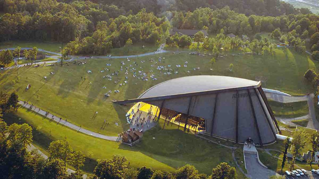
Blossom Music Center is located approximately 33 miles south of downtown Cleveland and 10 miles north of Akron on a plot of land surrounded by wildlife and trees, one of the only venues in Cleveland where one can listen to music under the stars. The amphitheater obtained its name from Dudley Blossom, who served as the Musical Arts Association president from 1936 to 1938. Before this summer home, the Orchestra performed at local venues such as the Public Auditorium and less frequently at Cleveland Municipal Stadium before baseball games. Since Blossom’s first opening season in 1968, the amphitheater has served as a place for people to gather and enjoy concerts for over 50 years.
George Szell, the conductor of the Cleveland Orchestra from 1946 to 1970, desired a permanent summer home for the orchestra and helped identify the Cuyahoga Valley as a viable option. The need for a summer venue for the Orchestra was due to its successful reputation; the summer festival was the only way to keep the skilled musicians in Cleveland. Despite everything—winter concerts, the pops, and country club dates—the Cleveland Orchestra's season could only be expanded with the Blossom amphitheater. Including the summer concert dates at Blossom would ensure the musicians could have full-time occupations.
Considering parcels of land fit for a location for Blossom was challenging. Szell consulted William A. Gould Associates on the search for sites. More than 80 properties were studied for development and eleven were even offered as gifts, but none met Gould's standards. Topographical needs helped narrow down the site options. The orchestra settled on a 500-acre plot of land between West Steels Corners Road and Akron-Peninsula Road. The rugged contours of its ground made it unsuitable for industry, but the natural bowl made it perfect for the orchestra. The land's natural slope helped influence the clam-like design of the Blossom Music Center amphitheater. 
Successful funding made the amphitheater eligible for a Ford Foundation grant, which required local organizations to raise $4 million within five years. $4,360,000 of the Half Century Fund's goal was used to construct the center. Through Szell's push to create Blossom Music Center and keep the musicians in Cleveland, their union was happy with the full-time opportunities.
The amphitheater was of modern design by a local architect Peter van Dijk, the son of Dutch immigrants. He worked on many projects throughout the Cleveland-Akron area, such as the restoration of Huntington Bank in downtown Cleveland. Van Dijk left his mark through the 1981 conversion of the old Akron post office into the Akron Art Museum and the construction of E.J. Thomas Hall.
Van Dijk thoroughly researched and visited successful amphitheaters, such as Ravinia, the summer home of the Chicago Symphony Orchestra, before he designed the Blossom Music Center. His dedication to researching and perfecting the design of Blossom allowed the incorporation of many modern linear elements reflected in the surrounding landscape. Materials used in this structure were concrete and weathering steel, which helped reinforce this venue's longevity and natural properties. The venue's clamshell-like shape had the acoustic advantage of allowing the sound to carry and reverberate throughout the crowd for up to three seconds, which was attractive to the Cleveland Orchestra. The form was also visually impressive.
Gearing up for breaking ground at the site of the new Blossom Music Center, the venue populated the <em>Cleveland Plain Dealer</em> almost daily, leading up to the first opening-season event. The turning of soil occurred on July 2, 1967, and on the same day, the <em>Plain Dealer</em> noted that this date also marked the orchestra's 50th anniversary. 
In 1968, Blossom Music Center's first opening season tune was Beethoven's overture, <em>Consecration of the House</em>, conducted by George Szell. With Blossom's capacity of 6,051 in the pavilion and 15,000 in the general admission lawn, this show was able to reach a large crowd, as the Orchestra desired.
Over the years, Blossom has had many concerts that appeal to the music community in Cleveland and Northeastern Ohio. Many artists have come to Blossom Music Center. Carole King, arguably the most successful female songwriter of all time, made an appearance Thursday, July 20, 1989, at Blossom Music Center. She is known for “Will You Love Me Tomorrow?" and "Tapestry" in 1971. For over 50 years, the Cleveland Orchestra has performed roughly 1,000 summer concerts at Blossom.</p><p>After many successful decades of Blossom Music Center's music season, there was a call for expansion with more significant revenue opportunities. By 2003, a $17 million updating of Blossom was completed. It created an addition for larger audiences of 3,624 lawn seats and 1,106 reserved seats, increasing the venue's total capacity to 23,500, helping ensure the venue's continuing importance as a leading performing arts center.</p><p><em><strong><a href="https://clevelandhistorical.org/items/show/980">For more (including 8 images) view the original article</a></strong></em></p>]]></summary>
    <published>2022-11-23T21:37:40+00:00</published>
    <updated>2026-03-04T21:32:05+00:00</updated>
    <link rel="alternate" type="text/html" href="https://clevelandhistorical.org/items/show/980"/>
    <id>https://clevelandhistorical.org/items/show/980</id>
    <author>
      <name>Catherine Reitz</name>
    </author>
  </entry>
  <entry>
    <title type="html"><![CDATA[Spice Acres <br />
: Sustainable Farming in Cuyahoga Valley National Park]]></title>
    <summary type="html"><![CDATA[<img src="https://clevelandhistorical.org/files/fullsize/82dc398cc2c7e9192d7b556c50c7f8a0.jpg" alt="Spice Acre SIgn" /><br/><p>On any given night people flock to Spice Kitchen on Detroit Avenue in Cleveland’s Detroit Shoreway neighborhood for great food, but diners might not realize where that food comes from prior to arriving at their table. Ben Bebenroth of Spice Kitchen has a 13-acre farm aptly named Spice Acres located in Cuyahoga Valley National Park which supplies some of the food that he cooks. The produce he grows also inspires the dishes he cooks, which vary based on what’s in season. The food he cooks in early summer will be vastly different than what appears on his menu in the early fall. What he doesn’t get from his farm he buys from local farmers in a 150-mile radius from his restaurant. Bebenroth is committed to the farm-to-table ideal as a means to provide the best cuisine to offer his guests. Even the floral decorations that grace the tables come from his farm. </p><p>Spice Acres is one of eleven farms that are part of the Countryside Initiative, which promotes sustainable farming practices within Cuyahoga Valley National Park. Those lucky few, like Bebenroth, who get a long-term lease, are then able to continue the tradition of sustainable farming practices. The process of acquiring a lease is a time-consuming process, in order to ensure that the lessee’s vision and business plan are in line with the Initiative’s stated mission. The Countryside Initiative was started in 1999 as a way to incorporate working farms into the National Park landscape. Farming was a part of the Cuyahoga Valley for generations prior to the suburbanization that started to consume farmland starting in the early 20th century. One farm that has been able to hang on is Szalay's Farm, which has been around for about 80 years. With the creation of the Countryside Initiative the plan was to implant farming ventures back into the Cuyahoga Valley as a means of education as well as allowing farmers to come in and farm the land. As part of the lease process, a farmer who is bidding on one of the current farms submits a business plan which outlines how they will use the land once they sign the lease. The application process takes several months to complete so as to ensure the right fit for the prospective farmer and farm. This process also helps to sort out those who are able to really farm for a long period of time. Once the application process is complete, the Initiative and the farmer enter into a 60-year lease agreement. </p><p>Bebenroth’s vision is to promote the farm-to-table ideal in which people are able to get food within a 150-mile radius of their home, which aligns with the Initiatives mission of preservation. What started as a small garden in his back yard led to signing a multi-year lease with the Countryside Initiative so as to expand his growing capacity for Spice Kitchen. At Spice Acres he brings that vision to life as he adds a variety of produce and livestock to his property to support the variety of menu items on offer at his restaurant. Thus far he has added pigs to his farming venture and hopes to continue to add other livestock to his ever-expanding farm bounty. Farming for Bebenoth has also become a way of creating an environment of social change on a local level. He has found that educating children is often easier than reeducating adults in healthy eating habits. Although he offers a variety of education programs that focus on being health-conscious in what they eat, Bebenroth also encourages people to be good stewards of the land. </p><p>In recent years Spice Acres has offered themed outdoor dinners, called Plated Landscapes Dinners, which feature in-season produce. As part of the dinner Bebenroth offers tours of his farm prior to the beginning of dinner, and he also engages with his guests during dinner. His hope is to show people the benefits of eating food that is grown closer to their home. Offering these outdoor dinners allows people to get a better feel of how the farm-to-table movement works and could have a positive impact on their daily lives. Interacting with people on his farm while having a meal together also allows for dialogue between those who grow the food and those who partake in the themed dinners. Interacting with his guests is an important aspect of his work, at both Spice Acres and Spice Kitchen, to inspire people to eat more local food. During the summer months he also allows families to visit his farm and encourages them to procure items from special meals from his farm. One example of people getting food items from his farm is obtaining flowers for their Easter table or a ham for Thanksgiving. </p><p>The Countryside Initiative has impacted how the Cuyahoga Valley National Park educates visitors on farming practices not only within the boundaries of the park but within the greater Cleveland-Akron area. Over the years the Initiative has increased its presence not only by leasing farms but also by setting up farmers' markets so people have a means of buying locally grown food, such as the farmers' market at Howe’s meadow during the summer months. The hope is to ensure that people can become more aware of how their food is grown and encourage engagement between the grower and the buyer. Allowing farmers to lease land from the Cuyahoga Valley National Park has meant that a way of life may be preserved for future generations to experience a way of life that is slowly fading from the American landscape.</p><p><em><strong><a href="https://clevelandhistorical.org/items/show/879">For more (including 10 images) view the original article</a></strong></em></p>]]></summary>
    <published>2019-11-20T20:07:44+00:00</published>
    <updated>2026-03-04T21:32:01+00:00</updated>
    <link rel="alternate" type="text/html" href="https://clevelandhistorical.org/items/show/879"/>
    <id>https://clevelandhistorical.org/items/show/879</id>
    <author>
      <name>Jenny Payne</name>
    </author>
  </entry>
  <entry>
    <title type="html"><![CDATA[Hale Farm and Village]]></title>
    <summary type="html"><![CDATA[<img src="https://clevelandhistorical.org/files/fullsize/9ae7439718714ed9a9954021f888f207.jpg" alt="Goldsmith House" /><br/><p>Walking through the Hale Farm and Village, visitors can hear the clanging of a blacksmith's hammer, feel the heat of a glassblower's kiln, and smell freshly cut timber from a woodworker's shop. The Hale Farm and Village is a living outdoor history museum that educates visitors about daily life in the nineteenth-century Western Reserve. The farm and village contain a collection of restored structures, including a church, log schoolhouse, law office, and several craft shops. In 1957, the Western Reserve Historical Society received the Hale Farm as a donation from Clara Belle Ritchie, the great-granddaughter of the farm's first owner Jonathan Hale. In the 1950s, the farm consisted of an 1825 brick home and surrounding outbuildings. Rather than risk the loss of her family's home and history, Ritchie offered the property to the WRHS on the condition that the society preserve the farm as a museum dedicated to local history.</p><p>Together, the Hale farm house and village testify to the nineteenth-century Western Reserve experience. At the farm house, visitors learn about the personal struggles and triumphs of Jonathan Hale and his family. The surrounding village presents additional aspects of life in the 1800s, including different forms of civic and religious participation. The church, for example, illustrates the importance of religion in the daily lives of Cuyahoga Valley settlers, while the land office teaches visitors about the area's immigration and financial history. Unlike the historic villages of Old Salem and Williamsburg, the Hale Farm and Village is a conglomeration of buildings moved to the site to represent significant elements in public and private nineteenth-century life.</p><p>In the later twentieth century, historians and history museum educators became increasingly concerned with representing the lives of ordinary people, rather than exclusively the rich, powerful, or famous. Museums like the Hale Farm and Village exemplify this more recent approach to history, which justified the preservation of a home and property that represented neither a grand form of architecture, nor the site of a famous man. The Hale Farm and Village, instead, emphasizes the interpretation and recreation of daily life, including family and community. </p><p><em><strong><a href="https://clevelandhistorical.org/items/show/344">For more (including 7 images) view the original article</a></strong></em></p>]]></summary>
    <published>2011-11-03T18:32:06+00:00</published>
    <updated>2026-03-04T21:31:59+00:00</updated>
    <link rel="alternate" type="text/html" href="https://clevelandhistorical.org/items/show/344"/>
    <id>https://clevelandhistorical.org/items/show/344</id>
    <author>
      <name>Carolyn Zulandt</name>
    </author>
  </entry>
  <entry>
    <title type="html"><![CDATA[Hell&#039;s Half Acre: The Canal Exploration Center at Cuyahoga Valley National Park]]></title>
    <summary type="html"><![CDATA[<img src="https://clevelandhistorical.org/files/fullsize/4a9ec2c4684141117ce7aa1574881688.jpg" alt="Sunset on the Canal" /><br/><p>Reputed to be a bootlegging tavern where numerous illegal and unsavory transactions occurred in the 1920s, the former inn at Hell's Half Acre now serves as the Canal Exploration Center for the Cuyahoga Valley National Park. Nineteenth-century life in the Cuyahoga Valley revolved around the Ohio & Erie Canal, the most important means of transportation between the valley, Cleveland, and Akron between 1827 and 1840. Completed in 1832, the Ohio & Erie Canal transformed how local farmers moved and purchased products. Using the canal, area farmers could ship their products, including corn, wheat, and whiskey, for an average price of five cents per ton, (as opposed to fifteen or twenty cents per ton by wagon). This connection to city markets also meant that the canal boats could bring back new luxuries for valley residents, including cloth, coffee, tea, and glass. </p><p>In addition to the exchange of commodities, the canal boats also brought visitors to the valley's small and formerly isolated communities. The Village of Peninsula, for example, thrived as a canal and mercantile town, receiving money and fame as canal travelers stopped by for some leisurely hours in the local dance hall or tavern. Hell's Half Acre, a tavern and inn located at Lock 38 along the canal, represented one of many local businesses that took advantage of the new clientele. During its 150 years, the building at Hell's Half Acre served as a tavern, store, private residence, boardinghouse, and blacksmith shop. Around 1837, Moses Gleeson purchased the property and structure to take advantage of the canal traffic. </p><p>The Ohio & Erie Canal shaped almost every aspect of valley life, changing both economic and social fabrics. The canal connected the Cuyahoga Valley to a national transportation system that stimulated growth and specialization for local farms. Instead of growing diverse sets of produce and grains, farmers chose one or two crops to grow in large quantities, such as oats for the Schumacher cereal mills in nearby Akron. Linked to New York's Erie Canal, the Ohio & Erie Canal also brought new residents to Ohio, which became the third most populated state in the 1840s. Irish and German immigrants also travelled to the Western Reserve as canal diggers, working long hours for little pay. Now a part of the larger state and regional economy, Cuyahoga Valley farmers learned about new equipment and scientific farming practices that arrived through new residents, farm journals, and agricultural fairs. </p><p>Although the Ohio & Erie Canal transformed daily life in the Cuyahoga Valley, the canal reached its zenith by the last decades of the nineteenth century. Unable to compete with the Pennsylvania & Ohio Canal and the Cleveland & Pittsburgh Railroad, producers used the canal less and less. Railroads, which skyrocketed in production in the 1860s, shipped products faster and with less dependency on weather conditions. A catastrophic flood in 1913 caused the final destruction of the valley's canals. </p><p>While no longer a tavern or inn, Hell's Half Acre remains an important location for valley visitors to learn about the history of the Ohio & Erie Canal. Presently the Canal Exploration Center, the structure hosts interpretive rangers for the National Park Service who conduct daily canal boat and lock demonstrations, as well as educate visitors about the canal's important role in the history of the Cuyahoga Valley.</p><p><em><strong><a href="https://clevelandhistorical.org/items/show/343">For more (including 6 images&#32;&amp;&#32;3 audio files) view the original article</a></strong></em></p>]]></summary>
    <published>2011-10-25T12:08:36+00:00</published>
    <updated>2026-03-04T21:31:59+00:00</updated>
    <link rel="alternate" type="text/html" href="https://clevelandhistorical.org/items/show/343"/>
    <id>https://clevelandhistorical.org/items/show/343</id>
    <author>
      <name>Carolyn Zulandt</name>
    </author>
  </entry>
  <entry>
    <title type="html"><![CDATA[Everett Road Covered Bridge]]></title>
    <summary type="html"><![CDATA[<img src="https://clevelandhistorical.org/files/fullsize/9ab884e24bda5a3f49d1985b5b578e75.jpg" alt="Crossing Furnace Run" /><br/><p>Passing by the Everett Road Covered Bridge, you can still hear the shuffle of feet moving to a lively tune. Both young and old come together at the bridge to share in a tradition passed down from the Cuyahoga Valley's first settlers from New England: the contra dance. Several times a year, friends and neighbors gather together to dance at historic locations near the Village of Peninsula. One of the most popular settings, the Everett Road Covered Bridge, allows dancers to connect to a tradition deeply rooted in the valley experience. Incredibly popular during the early 20th century, dances offered young men and women the rare opportunity to enjoy entertainment together. A local orchestra played while a caller announced instructions for the dances, which took place in nearby dance halls, or even in the street. The modern use of the Everett Bridge evokes these historic traditions of engagement with the local community.</p><p>The Everett Road Covered Bridge, which crosses over Furnace Run, is the only remaining covered bridge in Summit County. To take advantage of the Ohio & Erie Canal, and later railroads, valley residents needed roads. According to valley legend, the Everett Bridge was built in response to a local tragedy. In 1877, farmers John Gilson and his wife supposedly attempted to cross Furnace Run after melting ice made their usual ford impassable. Although Mrs. Gilson survived the stream, John Gilson's horse pulled him into the icy water where he soon drowned. Although historians concluded that the bridge was constructed in the late 19th century, its actual construction date remains unknown.</p><p>Nestled deep within the valley, the Everett community witnessed many changes since its beginnings in the 1820s. Visitors to the village in the 19th and early 20th century could cross Furnace Run through the covered bridge and enter a small neighborhood complete with a blacksmith, church, one-room schoolhouse, general store, saloon, dance hall, and railway station. After the establishment of the Cuyahoga Valley National Park, the Department of the Interior purchased and rehabilitated many properties in Everett. Despite the sense of loss that accompanied the demise of the lively Everett village, the Everett Road Covered Bridge and contra dance participants testify to the persistent sense of community in the valley.</p><p><em><strong><a href="https://clevelandhistorical.org/items/show/342">For more (including 5 images&#32;&amp;&#32;3 audio files) view the original article</a></strong></em></p>]]></summary>
    <published>2011-10-18T13:10:17+00:00</published>
    <updated>2026-03-04T21:31:59+00:00</updated>
    <link rel="alternate" type="text/html" href="https://clevelandhistorical.org/items/show/342"/>
    <id>https://clevelandhistorical.org/items/show/342</id>
    <author>
      <name>Carolyn Zulandt</name>
    </author>
  </entry>
  <entry>
    <title type="html"><![CDATA[Jaite Mill]]></title>
    <summary type="html"><![CDATA[<img src="https://clevelandhistorical.org/files/fullsize/33bf0e515d3d7606b562e8ea4c1914cc.jpg" alt="Factory and Former Canal" /><br/><p>During a trip on the scenic railway, visitors to the Cuyahoga Valley National Park will notice a collection of small yellow buildings clustered around the railroad crossing at Vaughn Road in Brecksville. Now the national park's headquarters, the buildings once comprised the railway depot and company village of the Jaite Paper Mill. A part of the valley's larger story of rising and falling industry, the Jaite Mill affected the lives of numerous valley residents in the early twentieth century.</p><p>Josephine Davis, who grew up in Brecksville in the 1920s and 1930s, remembers most of her immediate family members working for the Jaite Paper Company. During the twentieth century, competition from western agriculture made farming in the Cuyahoga Valley less profitable and more challenging. Although the Davis' farm produced enough food to feed her family, Josephine's parents, brothers, and sisters needed to help supplement the farm with additional income. For valley residents in Brecksville, Boston, and Peninsula, the Jaite Paper Company offered jobs conveniently close to home.</p><p>Charles Jaite founded the Jaite Paper Company in 1905 and purchased acreage in Northfield Township to begin construction. Charles, who emigrated from Germany as a young boy, had a history of paper manufacturing experience. At the age of thirteen, Charles worked at a paper mill in Cleveland, and eventually became the president of Standard Bag and Paper Company, and vice-president of the Cleveland Paper Company. Both businesses eventually became the Cleveland-Akron Bag Company, which opened in 1900 in Boston, Ohio. In July 1905, Charles resigned and decided to found his own business. </p><p>The Jaite Paper Company provided local farmers with extra construction work to create the buildings and connecting railroad. The mill's location provided easy access to the Ohio & Erie Canal and the Cleveland Terminal & Valley Railroad. In addition to providing jobs to local farmers, both the Jaite Mill and Cleveland-Akron Bag Company altered the ethnic makeup of the valley's population. Large numbers of Polish and other immigrants moved from Cleveland south to the valley to find work in the paper-making business. </p><p>By 1918, the mill employed about 250 people, including women who sewed bags and provided administrative help. Male workers used cylinder machines to produce "Blue Line Paper" for flour and cement bags. By 1919, the Jaite workers expanded production to include fertilizer bags and bread sacks. These workers made up the company town, which included homes, a general store, post office, and railway station. </p><p>Unable to compete with larger paper bag manufacturers, the Jaite family sold their company in 1951. The company exchanged hands several times before becoming a part of the Cuyahoga Valley National Park in 1975. </p><p><em><strong><a href="https://clevelandhistorical.org/items/show/341">For more (including 9 images&#32;&amp;&#32;3 audio files) view the original article</a></strong></em></p>]]></summary>
    <published>2011-10-18T12:49:05+00:00</published>
    <updated>2026-03-04T21:31:59+00:00</updated>
    <link rel="alternate" type="text/html" href="https://clevelandhistorical.org/items/show/341"/>
    <id>https://clevelandhistorical.org/items/show/341</id>
    <author>
      <name>Carolyn Zulandt</name>
    </author>
  </entry>
  <entry>
    <title type="html"><![CDATA[Jonathan Hale Farm]]></title>
    <summary type="html"><![CDATA[<img src="https://clevelandhistorical.org/files/fullsize/939f7d4ea161807a57ef748bf4a2267a.jpg" alt="Farm and Village" /><br/><p>In the southwestern Cuyahoga Valley sits a tall red brick house on over 140 acres of the Hale Farm and Village. Now a tourist destination and educational trip for school groups, the Hale Farm provides a window into 19th century valley farm life. Jonathan Hale arrived in the Western Reserve from Connecticut in 1810 to begin a new life of hard work and dedication to his farm. In 1824, Jonathan and his sons began laying each brick of the famous home, an architectural landmark in the Cuyahoga Valley. </p><p>Jonathan's son Andrew Hale, who inherited the farm after his father's death, increased the Hale Farm's size and productivity. Based on market demands, Andrew developed specialized farming practices, which included commercial orchards and dairy products. </p><p>The third generation to own and operate the Hale Farm, Andrew's son Charles Oviatt (C.O.) Hale (1884-1938), was a farmer in name only. Part of the newer generation of "gentlemen farmers," C.O. Hale transformed the farm into an inn and recreational retreat for friends and visitors. Hiring local families to work on his land, C.O. Hale oversaw the labor and production of fruits and vegetables, hay, and maple syrup. </p><p>In the 1930s, the great-granddaughter of Jonathan Hale and C.O. Hale's niece, Clara Belle Ritchie, inherited the farm. A business woman with a strong interest in the investment-value of the farm, Clara Belle supervised the farm's restoration and donation to the Western Reserve Historical Society. Visitors to the farm today experience a living history museum that features reenactments, crafts, and historical interpreters to educate about Western Reserve farm life in the 1800s. </p><p><em><strong><a href="https://clevelandhistorical.org/items/show/338">For more (including 5 images&#32;&amp;&#32;4 audio files) view the original article</a></strong></em></p>]]></summary>
    <published>2011-09-29T13:42:55+00:00</published>
    <updated>2026-03-04T21:31:59+00:00</updated>
    <link rel="alternate" type="text/html" href="https://clevelandhistorical.org/items/show/338"/>
    <id>https://clevelandhistorical.org/items/show/338</id>
    <author>
      <name>Carolyn Zulandt</name>
    </author>
  </entry>
  <entry>
    <title type="html"><![CDATA[Alexander&#039;s Grist Mill]]></title>
    <summary type="html"><![CDATA[<img src="https://clevelandhistorical.org/files/fullsize/d56eb7eaf12e6156fe7a10800afc99e7.jpg" alt="Alexander&#039;s Mill Water Power System" /><br/><p>The Ohio & Erie Canal, which was completed in 1827, allowed farmers in the Cuyahoga Valley to easily ship grain and other products to the growing markets in Cleveland and Akron. Water spilling over the canal's locks also provided a new source of power for mills and factories. Water from Lock 37, in present-day Valley View, powered the millstones of Alexander's Mill, which Andrew and Robert Alexander constructed in 1855 to serve local farmers. Now an Ohio & Erie Canal National Historic Landmark, Alexander's Grist Mill is the last surviving grist mill in Cuyahoga County.</p><p>In 1860, Ohio contained over 1,200 grist mills, although the remains of less than twelve existed as late as 1970. Grist mills ground grains such as wheat, oats, rye, and barley into flour and meal. Custom mills, such as Alexander's mill, depended on the seasons and harvest, and often processed grains for individual farmers and farm families. </p><p>Thomas and Emma Wilson, who had many years experience grinding oats, corn, rye and bran, purchased Alexander's Mill in the fall of 1900. The Wilson family expanded production at the mill, from which they sold wheat, rye, flour, scratch feed, and shelled corn. The mill, now known as Wilson Feed Mill, survived the valley's devastating 1913 flood which destroyed much of the canal. With a new water-power lease agreement to continue using Lock 37, the Wilsons resumed operations. By 1920, the Wilson family was selling flour and grains to larger commercial bakers and restaurants in Cleveland. </p><p>Today, visitors to Wilson Feed Mill can see vestiges of the mill's long history, including the water-power system's head-gates and turbines, in use until 1970. Thomas Wilson's descendants still manage the mill today, which continues to operate as a popular valley business, selling animal feed and other farm products. </p><p><em><strong><a href="https://clevelandhistorical.org/items/show/337">For more (including 6 images&#32;&amp;&#32;1 audio file) view the original article</a></strong></em></p>]]></summary>
    <published>2011-09-20T10:49:27+00:00</published>
    <updated>2026-03-04T21:31:59+00:00</updated>
    <link rel="alternate" type="text/html" href="https://clevelandhistorical.org/items/show/337"/>
    <id>https://clevelandhistorical.org/items/show/337</id>
    <author>
      <name>Carolyn Zulandt</name>
    </author>
  </entry>
  <entry>
    <title type="html"><![CDATA[Stanford House]]></title>
    <summary type="html"><![CDATA[<img src="https://clevelandhistorical.org/files/fullsize/f65496eb2c59911beac23585ef495569.jpg" alt="George Stanford&#039;s Home" /><br/><p>The Cuyahoga Valley's early settlers from New England arrived to find their purchased properties hidden beneath a wilderness of dense forest. By the early 19th century, small hamlets and townships developed where farm families cooperated and exchanged goods. James Stanford, who moved his wife and children from Pennsylvania to Ohio around 1802, participated in surveying parties who gathered information about communities throughout Summit County. After surveying near Boston Township, James decided to move his family to a nearby 169-acre property on the western bank of the Cuyahoga River. James and his wife Polly continued to live on and work the farm for the rest of their lives. Later owners included James' son George, and grandson George C. Stanford.</p><p>Creating a new and successful farm required hard work, perseverance, and patience. Farmers often waited up to five years for their farm to become self-sustaining, and even longer for their land to become prosperous. By the 1880s, George C. Stanford cultivated about 100 acres of the farm, and focused his efforts on raising wheat, hay, cattle, and sheep. Like all farmers in the valley, the Stanford family also kept a garden where they grew a variety of fruits and vegetables. </p><p>The history of the Stanford family illustrates the importance of participation in local communities during the early years of valley townships. George Stanford and his son George C. Stanford served in a variety of offices in Boston Township. Both father and son were elected as justice of the peace during their lifetimes. George C. Stanford additionally served as township assessor and Boston postmaster. Each generation's active community involvement lent prominence to the Stanford family name.</p><p>Like many of the valley's properties, the Stanford farm and house witnessed many occupants throughout the centuries before becoming a part of the Cuyahoga Valley National Park. The Stanford House now serves as lodging for the national park's visitors, who can eat, sleep, and explore the valley's past within the walls of this historic house.</p><p><em><strong><a href="https://clevelandhistorical.org/items/show/336">For more (including 5 images&#32;&amp;&#32;2 audio files) view the original article</a></strong></em></p>]]></summary>
    <published>2011-09-12T18:20:48+00:00</published>
    <updated>2026-03-04T21:31:59+00:00</updated>
    <link rel="alternate" type="text/html" href="https://clevelandhistorical.org/items/show/336"/>
    <id>https://clevelandhistorical.org/items/show/336</id>
    <author>
      <name>Carolyn Zulandt</name>
    </author>
  </entry>
  <entry>
    <title type="html"><![CDATA[Valleyview Homes Estates]]></title>
    <summary type="html"><![CDATA[<img src="https://clevelandhistorical.org/files/fullsize/press-valleyview40_c9c9eea7ab.jpg" alt="Valleyview Homes, 1940" /><br/><p>In Cleveland, several public housing projects (Cedar-Central, Outhwaite, Lakeview Terrace) preceded the development of Valleyview Homes Estates. However, Valleyview was among the first (along with Woodhill and Carver Park) to actually be built and overseen by the Cleveland Metropolitan Housing Authority (CMHA). Completed in 1940 on a bluff overlooking the Cuyahoga Valley in southeastern Tremont (then known as South Side), Valleyview was comprised of two-story brick buildings containing a total of 582 apartments . The project cost nearly $3.5 million and featured playgrounds, a community center, and craft shops. Local artists commissioned by the Works Progress Administration (WPA) created numerous murals and other pieces of art, which were placed in various spots throughout Valleyview.</p><p>Despite the 1949 passage of a city ordinance banning racial discrimination in public housing, Valleyview—like virtually all public housing on the west side of Cleveland—remained segregated for decades. Integration was finally achieved in the early 1970s. By this time, however, federal limits on the percentage of a family's income that could be collected left too little rent revenue to cover the costs of maintenance. CMHA thus became more dependent on federal money; but the government provided only 90 percent of funds required for maintenance and less than half of other expenses. At Valleyview, upkeep faltered, and arson, drug dealing, and physical deterioration increased. More and more residents left. By 1978, police officers refused to enter Valleyview without two-person patrols. </p><p>By the 1980s, Valleyview clearly was on its last legs. The death knell was Clark Freeway, the highway that had caused so much controversy two decades earlier when County Engineer Albert Porter sought to route it through Shaker Lakes. That effort failed, but by 1990 the Ohio Department of Transportation had successfully run Clark Freeway—now the Troy Lee James Freeway (I-490)— through South Tremont. The massive Clark Fields park was carved in two and most of the original Valleyview Homes were razed. In 2004, buoyed by a $19.6 million Hope VI grant, the remaining units structures were torn down, and construction began on Tremont Pointe, a mixed public/private development. </p><p>Perhaps the greatest living legacy of Valleyview Homes is its collection of WPA art. Several of Valleyview’s sculptures are on display at Tremont Pointe. Also at Tremont Pointe—behind a large wall of glass at the complex's northwest corner—is the terra cotta Valleyview Mural. Designed by Leroy Flint and executed by Henry Olmer, the mural is essentially a topographic roadmap of the old Valleyview neighborhood.  Other pieces formerly housed at the site are on view at Cleveland State University and CMHA’s headquarters on Kinsman Road.  </p><p><em><strong><a href="https://clevelandhistorical.org/items/show/104">For more (including 9 images) view the original article</a></strong></em></p>]]></summary>
    <published>2010-11-27T16:17:09+00:00</published>
    <updated>2026-03-04T21:31:58+00:00</updated>
    <link rel="alternate" type="text/html" href="https://clevelandhistorical.org/items/show/104"/>
    <id>https://clevelandhistorical.org/items/show/104</id>
    <author>
      <name>Michael Rotman</name>
    </author>
  </entry>
</feed>
