The Rouse Block, Public Square
The Evolution of Downtown's 'Westward Gate'

For well over a century, the block facing Public Square's northwestern flank hummed with commercial vitality. By the closing years of the nineteenth century, the block was rapidly transforming into a wall of modern office buildings. But when a plan for a grand bank tower faltered about a hundred years later, one of downtown's most iconic locations was left with nothing more than a vast parking lot. Public Square would spend the next three decades looking incomplete until one of Cleveland's oldest large corporations filled the gap.
The Sherwin-Williams Company, a manufacturer of paint and accessory products, has been a constant presence in Cleveland for more than a century and a half (since 1866). In 2020, the ever-growing enterprise acquired the longtime vacant block on the northwest side of Cleveland’s Public Square and announced plans to build a new corporate headquarters on this and two adjacent blocks along West 3rd Street. Prior to the paint giant's announcement, the site had languished for thirty years as a surface parking lot even as Public Square underwent a sweeping redesign and many other surrounding blocks saw renovations. But Sherwin-Williams is only the newest lead actor in a more than two-century drama of central urban space in the heart of downtown Cleveland.
Polly and Turband Kirtland were married in 1793 in Massachusetts. Turband’s relationship with Moses Cleaveland led him to establish his home in Poland, Ohio (near Youngstown) and conduct Connecticut Land Agency business in the new and growing settlement along the Cuyahoga River. On one visit in 1798, Mr. Kirtland bought a two-acre plot on the northwest corner of Public Square for $30.00. Fifteen years later, he sold the plot for $200 to Leonard Case who retained the space until the mid 1830s when Deacon Benjamin Rouse arrived in town as an agent of the American Sunday School Union to establish schools and book depositories and a church on the Public Square space.
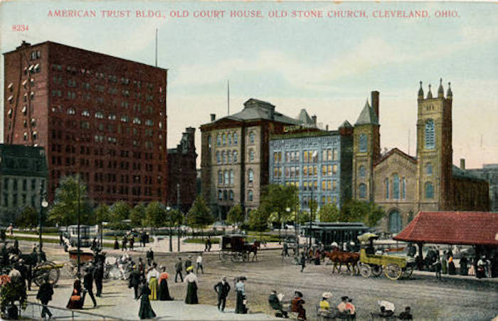
Mr. Rouse led Baptist and civic efforts from the south side of the ’Rouse Block’ in Cleveland throughout the pre- and post-Civil War years. Over the years, the word "block" has been used interchangeably as a city block bounded by streets, as a building site within a city block, and as a title for a block-face – one side of a city block. Rouse’s wife, Rebecca, was equally ambitious with the Soldiers’ Aid Society, Cleveland Ladies Temperance Union, the Martha Washington & Dorcas Society, and other civic enterprises. Mrs. Rouse is enshrined in the Soldiers and Sailors Monument. During this period, the Rouse Block developed gradually to house several facilities adjacent to the Rouse building on the corner of Superior and Public Square, including hotels and offices. The Rouse Block was defined by (original/current) street boundaries – Superior to the south, Seneca/West 3rd to the west, Frankfurt on the north, and Public Square/West Roadway on its east edge. This latter block-face poses the focus for this discussion.
The post–Civil War period brought rapid industrial, commercial, and community growth supporting central downtown development in Cleveland. By 1881, investment and developments of the Rouse Block led to its designation as the Lyman Block. The northernmost lot on the block was the site of the Mohawk Building in 1896 which housed the Mohawk Realty and McAllister & Dall, and was to be renamed the American Trust Building in 1898. The building survived into the mid-twentieth century as the Ulmer Building and later as the 33 Public Square Building. It was neighbored by the Perkins Building in the center of the block-face which became the Dime Savings Bank by 1896. A corner drugstore finished the walk to the south at Superior Street.
W. G. Marshall, a drugstore chain owner, negotiated a 99-year lease of the Superior Street corner property from heiress Ellen Rouse Prentiss and in 1913 razed the Rouse building to build the Marshall Building. This solidified the western face of Public Square for the next eighty years. Marshall promptly began reconstruction of his corner building to raise the office building to 15 stories atop the retail drug store on the street level.
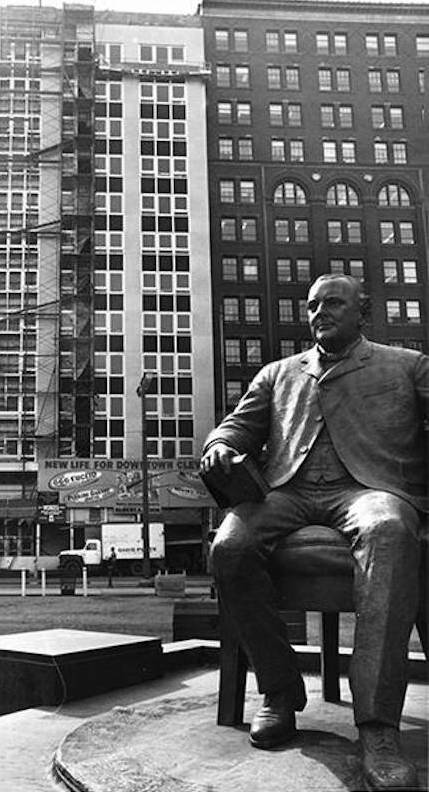
By the 20th century’s second decade, The Rouse Block featured two 15-story office buildings with a little four-story building in the middle which journalist S. J. Kelly termed the Morison Block. Dating to the 1870s, the Morison Block housed a variety of law firms, realty agencies, and The Dime Savings Bank over the years. Ultimately, by the early 20th century, restaurants occupied the ‘little’ building which lent occasional stories of fires, fights, and illegal activity at the space. Early in 1964, the announcement to demolish the little building was published. It was replaced with an addition to the Marshall Building and would complete the 15-story west face of Public Square. Two years later, “1 Public Square” opened for tenants, developed and renovated by Albert A. Levin.
Another decade posted more changes to the Square’s western face. Robert Levin, Albert’s brother, presided over the West Public Square Corporation. Ameritrust Company and other new banking and legal tenants moved into the ‘Number One Public Square’ building and remodeled much of the space. Levin expressed his hope for a clean, vendor-free, debris-free square prompting a major revival for Cleveland’s central showcase. During the 1980s, the Ameritrust Corporation, developers Jacobs, Visconsi, and Jacobs and Cleveland’s Voinovich administration negotiated the development of a 60-story Ameritrust office tower and adjacent Hyatt Regency hotel to be completed by 1996 in the Rouse Block space. Numerous planning delays combined with financing challenges and Ameritrust’s declining business left the project languishing after the One Public Square Building and 33 Public Square were demolished in 1990. Ameritrust ultimately accepted a takeover bid by Society Corporation which, incidentally, was building an office tower and hotel complex on the north face of Public Square. The Rouse Block remained a surface parking lot on Public Square’s western face until the 2021 ground breaking for the Sherwin-Williams Global Headquarters. The two-block complex features a "two story pavillion serving as a front porch to public square" occupying the original Rouse Block.
Images