Filed Under Transportation

Ohio and Erie Canal

Building a Connection Between Lake Erie and the Ohio River

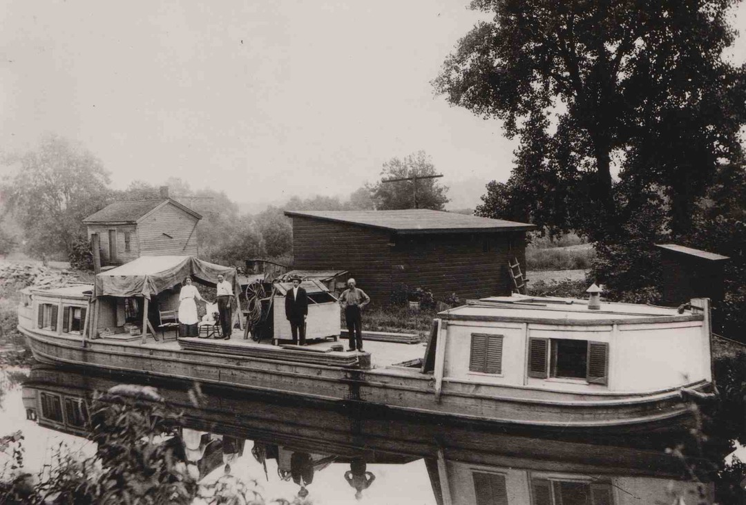
It is hard to imagine Cleveland developing into the city that it did had it not been chosen to be the northern end of the Ohio & Erie Canal. George Washington discussed the possibility of building a canal to connect Lake Erie with the Ohio River as far back as the 1780s, but it was not until 1825 that the Ohio Legislature voted to fund the project and construction commenced. An initial span opened between Akron and Cleveland on July 4, 1827. When fully completed in 1832, the Ohio & Erie Canal travelled 308 miles through 146 lift locks on its path between Cleveland and Portsmouth, Ohio.

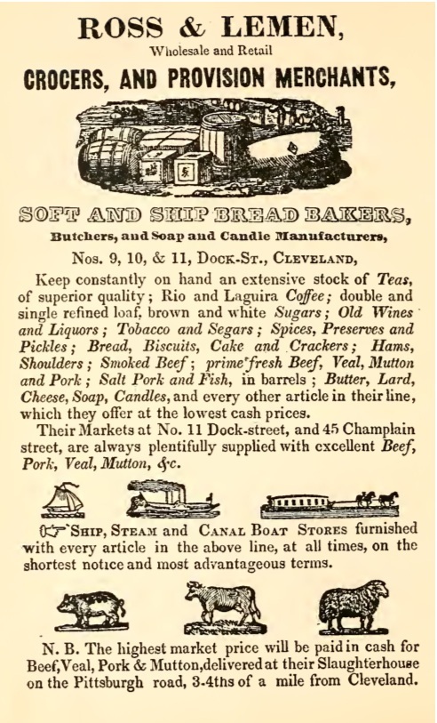
The canal almost instantly turned Cleveland into a major commercial center. The city became the hub of a continental transportation network that connected with New York City via Lake Erie and New York's Erie Canal as well as with the nation's developing frontier areas and New Orleans via the Ohio and Mississippi Rivers. Goods like wheat, corn, coal, and lumber came north to Cleveland from the frontier while manufactured products from factories in the northeast arrived in Cleveland in return. Travel by road at this time – in places where actual roads existed – was unreliable and expensive. The canal dramatically cut the cost of transporting goods. It opened up new markets for manufactured goods, and tied Americans living at the margins of the nation into an expanding national economy.

The banks of the Cuyahoga River soon became populated with warehouses, docks, and shipyards. It was not long before the area became a center of industrial production as enterprising Clevelanders started turning the raw materials arriving from the hinterlands via the canal into new and highly demanded products like steel and petroleum. Many of the Irish immigrants who built the canal remained in town to work in these new industries.

Traffic and revenue on the Ohio & Erie Canal peaked around the 1850s. Already by then, railroads were taking over as the dominant mode of transportation. Cleveland, which had already established itself as a major city thanks to the canal, continued to prosper. Raw materials and finished goods poured into and out of town, but they did so on boxcars instead of canal boats.

The canal gradually fell into disuse. Steel factories tapped into it for use in their mills and flooding occasionally wiped out portions of it. Towards the end of the twentieth century, portions of the Ohio & Erie Canal came under the protection of the National Parks Service with the creation of the Cuyahoga Valley National Park. Other federal and local projects have preserved many sections of the canal. Thanks to these efforts, future generations will be able to view Ohio's original interstate highway system: the man-made ditch that brought prosperity to Cleveland on the deck of a canal boat.

Video

Reinventing the Canal Dan Rice describes how the canal has remained relevant through reinvention. Source: CSU Center for Public History + Digital Humanities
"The Ditch That Brought the World to the Wilderness" Jack Gieck describes the impact of the canal system on Ohio's economy. Source: CSU Center for Public History + Digital Humanities

Images

Canal Postcard, ca. 1900
Canal Postcard, ca. 1900 Railroads became the dominant form of commercial transportation around the time of the Civil War, quickly making canals obsolete. Much of the Ohio & Erie Canal was abandoned and became used primarily by recreational boaters, such as the boys depicted in this idyllic canal scene around 1900. Source: Cleveland Public Library Date: ca. 1900
"Ross & Lemen" Ad, 1837
"Ross & Lemen" Ad, 1837 An 1837 advertisement for a Cleveland grocer demonstrates some of the commerce being created in the city by the Ohio and Erie Canal. The opening of the canal quickly turned Cleveland into one of the nation's largest transshipment areas. Farmers from the interior would send their crops (especially wheat) north to the city, while imported and manufactured goods arrived in Cleveland from the east and were then purchased by farmers and city dwellers alike. Around the time of the Civil War, however, Cleveland changed from having a mainly commercial economy and became itself a center of manufacturing and heavy industry. Source: Library of Congress Date: 1837
Canal Map, 1837
Canal Map, 1837 Near the bottom of this 1837 map can be seen the point where the Ohio and Erie Canal merged with the Cuyahoga River in Cleveland. The junction contained Locks 43 & 44 as well as a 150-foot wide turning basin in between the two locks. In 1851, the state constructed a weigh lock near this site. The Cleveland weigh lock was the only one of its kind on the Ohio & Erie Canal and (as its name suggests) was designed to determine the weight of a ship's cargo in order to assess accurate tolls. Source: Library of Congress Date: 1837
Canal Boat Family, 1896
Canal Boat Family, 1896 Source: Cleveland Public Library Date: 1896
On the Canal, 1896
On the Canal, 1896 This photograph from 1896 illustrates the origins of the term "towpath." Horses or donkeys tethered to canal boats would literally "tow" the boats along the canal while walking on dirt paths that extended throughout the length of the canal. While top speeds only reached a few miles per hour, this was still a vast improvement over the unreliable and often impassable dirt roads that existed at the time the Ohio & Erie Canal opened. Source: Cleveland State Library Special Collections Date: 1896
Canal Visitors Center, 2010
Canal Visitors Center, 2010 The Canal Visitors Center in Valley View is located in a former inn and tavern for canal travelers that once earned the moniker "Hell's Half-Acre." The Visitors Center is part of the Ohio and Erie Canal Historic District, a four mile section of the canal that became a National Historic Landmark in 1966. Source: CSU Center for Public History and Digital Humanities Date: 2010
"Hell's Half Acre"
"Hell's Half Acre" The tavern and inn shown here - known for a time as Hell's Half Acre due to its rough reputation - sits in front of Lock 40 on the Ohio and Erie Canal. It now houses a visitors center that features historical exhibits about the canal. Source: Cleveland State Library Special Collections

Location

7104 Canal Rd, Valley View, OH | The Canal Exploration Center is located along the Towpath Trail at Cuyahoga Valley National Park.

Metadata

Michael Rotman, “Ohio and Erie Canal,” Cleveland Historical, accessed July 26, 2024, https://clevelandhistorical.org/index.php/items/show/52.