Filed Under Environment

Lower Shaker Lake

On a July night in 1921, a group of "Cleveland hoodlums" fought with members of the Shaker Heights Police Department after being ordered out of Lower Shaker Lake. The young men were not happy about being told that they could not swim in the lake at night. In the ensuing scuffle, the police beat a number of bathers and an officer fired his gun in the air. A few of the bathers made a run for it -- in the nude. One was eventually picked up by a Cleveland police officer on the alert for "a naked boy seen lurking in shrubbery on Kinsman Road." The North Union Shakers would have certainly been shocked to witness such a riotous scene.

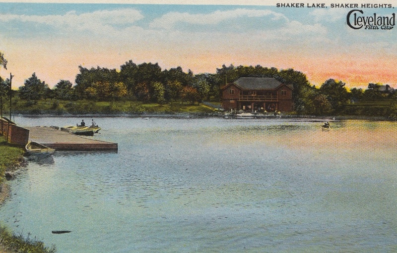
During its 190 years of existence, Lower Shaker Lake has gone from being an example of industriousness and self-sufficiency to being a place where people go to have fun and enjoy nature. The North Union Shakers first dammed the Doan Brook in the 1820s to power a saw mill located just west of the newly-created Lower Shaker Lake. In 1829, a portion of the original Shaker settlement at Lee Road and North Park Boulevard moved to a location nearer to the sawmill and Lower Shaker Lake. The "Mill Family," as it became known, worked and lived communally, sharing the large "Family House" near the northwest shore of Lower Shaker Lake. The "Family" (actually a group of thirty or so mainly unrelated Shakers) operated the saw mill and, eventually, a five-story high grist (corn and flour) mill located in Doan Brook Gorge. As the 19th century came to a close, the North Union Shaker community steadily grew smaller. Older Shakers died, while new members proved hard to recruit, probably due to the strict practice of celibacy in the Shaker Church. In 1889, the North Union Shaker community disbanded, and the 20 or so remaining members moved to other Shaker communities. Their dams on the Doan Brook, however, remained.

In 1896, the Buffalo real estate company that now owned the old Shaker lands donated 279 acres of it, including Lower and Upper Shaker Lake, to the City of Cleveland. The new parkland followed the path of Doan Brook, connecting with Ambler Park, Wade Park, Rockefeller Park, and Gordon Park to create a nearly continuous stretch of parks from Shaker Heights to Lake Erie. Lower Shaker Lake quickly attracted swimmers, canoeists, and picnickers. In the 1910s and 1920s, when the Shaker Lakes Canoe Club was at its peak, its two-story clubhouse on the lake's southeast shore was the site of annual regattas that attracted thousands of spectators. The regattas featured traditional canoe races as well as competitions in the less well-known sports of "canoe tilting" and "canoe polo."

In the 1960s, however, the future of Lower Shaker Lake was threatened by a proposal to construct a freeway interchange just east of the lake. The Clark Freeway would have run parallel to the lake's south side before intersecting with the Lee Freeway near the spot where the Nature Center at Shaker Lakes now sits. Founded in 1966, the creation of the Nature Center was a key part of the dedicated effort by local residents to prevent the freeways from being built. Thankfully, the protests worked and the freeways did not get built. While the young men who dashed naked from the lake in 1921 did not win their fight against the police, the men and women fighting against the Clark and Lee Freeways several decades later won the right to continue enjoying the Shaker Lakes. It is safe to say that victory was deserved in both cases.

Audio

Seeing the Shakers Clara Taplan Rankin tells about her mother's trips into the Shaker community with her father. Source: Cleveland Regional Oral History Collection
"It Was a Mysterious Place" Clara Taplan Rankin describes the Shaker Lakes in the 1930s. Source: Cleveland Regional Oral History Collection

Images

Lower Shaker Lake, ca. 1920
Lower Shaker Lake, ca. 1920 This postcard of Lower Shaker Lake features a view of the Shaker Lakes Canoe Club's boathouse, constructed in 1914 near the intersection of Larchmere and South Park Boulevards on the lake's southeast shore. The structure's lower level had space for over 25 canoes, while the second level contained a clubhouse. As membership in the Canoe Club dwindled in the decades following World War II, the boathouse fell into disrepair. By the 1970s, the Shaker Heights Fire Department was using it for training, often hacking away at the wooden building with their axes. Shaker Heights decided to raze the boathouse in 1976. A portion of its foundation and a cement boat ramp remain today. Source: Shaker Historical Society
Grazing at Shaker Lake, 1876
Grazing at Shaker Lake, 1876 North Union Shaker Elder James S. Prescott (1803-1888) was a stonemason who helped build the dam that created Lower Shaker Lake in the mid-1820s. He is pictured here at Lower Shaker Lake in 1876 with a group of youngsters as a herd of the Mill Family's cows graze on the opposite shore. Source: Shaker Historical Society
Mill Family Buildings
Mill Family Buildings The large building in this image is the Mill Family's "family house." The house sat west of Coventry Road, near its intersection with North Park Boulevard. Everyone from the Mill Family lived in the house, but men and women remained apart at all times. Also pictured are barns and a cheese house. Other buildings in the Mill Family's settlement included a woodshed, a milk house, a cooper shop, and an ice house. None of these structures remain standing today, having been torn down following the abandonment of the North Union settlement in 1889. Source: Shaker Historical Society
Mill Family Map
Mill Family Map This map shows the layout of the Mill (sometimes referred to as "North") Family's settlement west of Lower Shaker Lake. The "Family" formed in 1829 as a subset of the North Union Shakers. They were tasked with operating the mills powered by the damming of the Doan Brook (which led to the creation of Lower Shaker Lake) in the mid-1820s. In addition to a saw and grist (or flour) mill, the Mill Family's property also contained a number of other farm buildings, as well as a single"family house" that contained living quarters. Source: Shaker Historical Society
Mill Stone at Shaker Square
Mill Stone at Shaker Square This mill stone was originally used at the Shakers' 50-foot high grist mill in Doan Brook Gorge. A grist mill turns grain into flour and corn into meal. Farmers from around the area would pay the Shakers to have their crops milled at their grist mill. The Shaker Historical Society and the Shaker Square Association placed the stone at Shaker Square in 1947 to commemorate the 125th anniversary of the North Union Shakers. In 1886, the mill stone was taken to the saw mill just west of Lower Shaker Lake. The saw mill had just been destroyed by fire, so the Shakers built a new grist mill at the site using this stone. In 1889, however, the North Union Shaker Community, then numbering only in the twenties, disbanded, and the mill fell into disuse. The 50-foot high grist mill in Doan Brook Gorge was blown up on July 4, 1886, as part of an Independence Day celebration. A local newspaper reported that "The old Shaker Mill went up in a blaze of glory" as 4,000 spectators looked on. Creator: Christopher Busta-Peck
"Magnificent Lake," 1911 Ad
"Magnificent Lake," 1911 Ad This advertisement appeared in the Cleveland Plain Dealer in 1911. It offers home sites for sale in the Coventry Subdivision of Cleveland Heights. Real estate developers often highlighted the suburbs' natural beauty, appealing to wealthy Cleveland residents fed up with the smoke and tumult of the big city. Suburban commuters wanted to get to their jobs Downtown quickly, however, which is why this ad mentions that the subdivision is "35 minutes from [Public] Square" via streetcar. The Van Sweringens' rapid transit line, which began running in 1922, shortened the time of this commute even further.  Source: Cleveland State University Library Special Collections
Canoe Club Regatta, ca. 1910
Canoe Club Regatta, ca. 1910 The original Shaker Lakes Canoe Club boathouse, pictured in this postcard, was built in 1907 on the southeast shore of Lower Shaker Lake. The highlight of the club's year was its annual regatta, a tradition that began in 1908. Thousands of people would attend these summertime festivals which featured canoe races, canoe tilting (similar to medieval jousting, but with canoes in place of horses), and moonlit water parades of Japanese lantern-lit canoes. Source: Cleveland Heights Historical Society
"50 Children See Girl Die in Lake," 1913
"50 Children See Girl Die in Lake," 1913 Several drownings occurred at Lower Shaker Lake in the 1910s and 1920s. Canoes, which could easily tip over, were often involved in these accidents. In 1913, Cleveland City Councilman John Andrews even said that the Park Department "might as well leave a lot of pistols within reach of children" if it continued to "leave canoes where children can get them." The number of drownings eventually declined as the city instituted bans on swimming, and canoeing declined in popularity. Source: Cleveland State University Library Special Collections
Proposed Highway Interchange
Proposed Highway Interchange This artist's rendering shows the 1960s proposal for a highway interchange just east of Lower Shaker Lake. The Clark and Lee Freeways would have intersected where the Nature Center of Shaker Lakes is now located. Lower Shaker Lake would have remained mainly intact, but with the Clark Freeway running alongside its entire southern shore. Source: Cleveland State University Library Special Collections

Location

Brook Rd, Cleveland Heights, OH | Unpaved hiking trails line both the north and south shores of the lake.

Metadata

Michael Rotman, “Lower Shaker Lake,” Cleveland Historical, accessed July 3, 2024, https://clevelandhistorical.org/index.php/items/show/426.